§ 3. Geography of ancient days
Opening shape the earth. Knowledge about the shape of our planet were extremely important for further development of geography and especially for create reliable maps. In ancient times (VIII Art. BC. BC - IVArt. district. E.) highest development of knowledge, including geographical, was in ancient Greece. That time travelers and merchants reported newfound land. Before scientists facing a big challenge - to bring these disparate data into one. The main thing that it was important to decide which of the Earth - flat, cylindrical or cubic - relating to acquired data. Greek scientists have thought about many, why? ". Why ship away from shore, suddenly disappears from view? Why is our view impeded by some obstacle - the horizon? Why lifting up expanding the horizon? The idea of a flat Earth did not give answers to these questions. Then therehypothesisform of the Earth. In science hypotheses have not been called assumptions or guesses.
The first assumption that our planet has the form of bullets, yet expressed inVArt. BC. BC Greek mathematicianPythagoras. He believed that the basis objects are numbers and shapes. Most advanced of all the figures are field, ie the ball. "Land must be perfect - Pythagoras pondered. - It must therefore take the form of spheres. "
Has proved sphericity of the Earth in the fourth century. BC. BC another Greek -Aristotle.For proof he took a rounded shadow that Earth casts on the moon. This shadow people when they see lunar eclipse. No cylinder or cube, or any other form is not give a circular shadow.Aristotlerelied also on observation horizon. If our planet was flat, then the clear weather in our eye telescopes have seen far to the ends. Availability horizon due bend, sphericity of the Earth.
Irresistible evidence of the assumption of Greek genius were obtained through 2500 astronauts.
The geographical literature and maps.Lessons travelers and seafarers information about previously unknown land uzahalnyuvaly Greek scientists, philosophers. They wrote many works. The first geographic work created Aristotle, Eratosthenes, Strabo.
Eratosthenesused data history, astronomy, physics and mathematics for the separation of geography independent science. He was the oldest and the map that came before us (III. To district. AD). It depicted a scientist known at the time ofEurope, AsiaіAfrica. Not by chance Eratosthenescalled the father of geography, indicating acknowledgment of its merits in its development.
In the second century.Claudius Ptolemyamounted to more modern maps. It is known to Europeans the world was much broadened. The map showed many geographical features. However, she was very rough. Despite these "little things" cards and "Geography" in 8 booksPtolemyenjoyed 14 centuries! Labor Greek scientists suggest the origin of geography as a true science is in ancient times. But it was largely descriptive. And on the first card was reflected only a small part of space. Instead, more than
 Interesting geography
First geographical document
This document believed poem Odyssey. Its wrote a famous poet of ancient Greece by Homer as think in Article IX. BC. e. This piece of literature contains a geographical description of many well-known at the time areas of the world.
 Interesting geography
Drafting first card
Even during military campaigns Greeks did not leave the desire to write all, that they saw. In the Army of the outstanding EmperorAlexandraMacedonian (he was a studentAristotle) Administered special pedometer. These people were counting distance traveled, were descriptions routes and deposited them on the map. Based on these data, another studentAristotle – Dikearhwas quite detailed map of land then known.
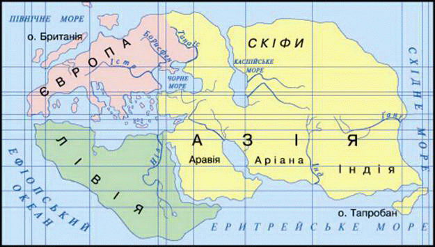
Fig. World MapEratosthenes(III. To BCE.)
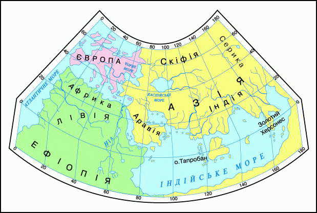
Fig. World Map ClaudiaPtolemy(Second century).
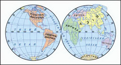
Fig. Modern physical map of the hemispheres
The first information on the Ukrainian lands.InVArt. BC. AD Greek traveler and historianHerodotusvisited on the Black Sea - where is now Ukraine. All saw and heard during this and other trips, he outlined in 9 books "History". With this heritage Herodotus called the father of history. However, their descriptions, he said and a lot of geographic information. Herodotus or information is Geography is not the only monument south of Ukraine. At that time there was a large country ScythiaSize to cause the biggest surprise of overseas guests. For centuries, people learned from the History Herodotus of Europe, Asia, Africa. We left the Greek scholar reliable information about our area. Following them and the subsequent 500 years of evidenceStrabonWe got a clearer idea of our land.
 FAQ
task
FAQ
task
1. Who owns the first correct idea of the shape of the Earth?
2. What evidence cited in favor of the Greeks spherical shape of our planet?
3. Who were the first by geographical work?
4. When and by whom was created the first maps?
5. What are the continents and seas were known compilers cards first?
6. Compare mapsEratosthenes і Ptolemywith modern maps and set different hemispheres image in Europe, Asia and Africa.
 English