§ 4. Geography Middle Ages
Idea about the world in the Middle Ages.In the Middle Ages (V–ХVcent.) science declined, that the effect on geography. The spread of religion in Europe made people forget about the scientific achievements of Greek scientists. Instead, spread such ideas about the Earth, which displays the image of medieval chronicle. Often they have a fantastic nature and reflect religious beliefs. Thus,VAnd art. monk from ConstantinopleKozmaIndykoplovasserted that the earth - flat quadrangle. On It is a huge mountain, which goes around the Sun. Ironically, this false opinions existed until XVArt. It was a giant step backward in development geography.
Together with those merchants who became wealthy from trading overseas goods and conquerors who seized new lands, organized more and more travel. They were inhabitants of geographic informants who satisfy curiosity and practical needs.
Travel Marco Polo.The first European who made a trip to South Asia, was Marco Polo - son Italian merchant from Venice. His father carried on trade in Asia and repeatedly been on the mysterious East. Starting out in 1271 to China Polo took with senior and a 17 year old Marco. More than 3 years because of the turbulent rivers, high mountains, Desert got great merchants travelers to China. There they took Khan. That maintain relations with Europe, he invited Marco Polo intelligently to their service. This enabled the Italians to make a lot of traveling China. Service Marco Polo in Khan stretched for 15 years and return home - even at 10! In He returned to Europe by sea along the coast of Asia. The route of his trip appeared huge loop, described around South Asia.
Back home, Traveler, "presented" Europe is seen as a book manuscript on diversity of worlds. " In it he revealed the real face of the Europeans far, East Asian unprecedented. Marco Polo was not a geographer or even suspected the existence of this science. However, his message became a valuable source of knowledge. Even after 200 years of geographical names in his book cited on many maps. "Book of Marco Polo translated into numerous languages and published in different countries. Written over 700 years ago, and today it attracts readers.
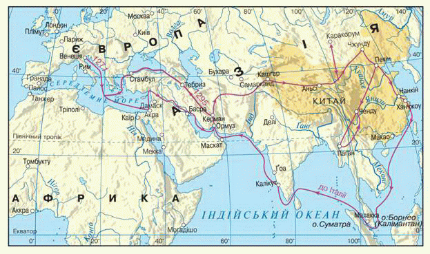
Fig. Routes Travel Marco Polo (thirteenth century).
Travel Ibn Battuty.Often pilgrimage - a trip to the holy defined by religion, places - turned invaluable for educational trips. On a pilgrimage to Muslim holy sitesMedinaandMeccaThat in Saudi Arabia in 1325 he began his wanderings Arabs from MoroccoIbn Battuta. He passed through allNorth Africa, Went toMiddle Eastsea swam toMozambique andZanzibar. His ways reachedVolgaі Central Asia. SubsequentlyIbn Battutagot toIndia. He 7 years lived in Delhi, and, like Marco Polo, served Sultan. He then traveledChina. Traveler returning home for many years through Southeast Asia. In general trip lasted 24 years.
Interestingly, Arab traveler who visited Ukraine and on land - inCrimea. Ibn Battutastayed inc. Kerchand CastleSolhat(Now Old Crimea). And his greatest hitKafa(Feodosia). Numerous ships have reviewed and left the port. They carried grain, cloth and fur with Muscovy, the slaves of Caucasus and the Volga region. Traveler who has seen many ports, Cafu carried to most important in the world.
Their memories of the tripIbnTrampolines set out on pages books"Gift curious about dyvovyzhi cities and wonders Travels ". Description of China lifted the veil of mystery, that secret life of Europeans peoples in the East.
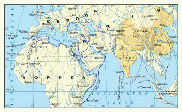
Fig. Routes TravelIbnTrampolines (XIV century).
Development Studies.In the medieval geographical knowledge acquired more practical orientation - stranovedcheskoy. This required the development of trade and shipping.
Labor contemporary scholars in the descriptive form placed everything: the geographical and biological, and religious and historical, and cultural and economic information any country. Country achieved great success. Books, which described a foreign land, were very popular. Later, from a simple collection of geographical facts scientists begun to address the links between them.
 Interesting
geography
Interesting
geography
Medieval chronicles - the source of geographical knowledge
Medieval chronicles of Kievan Rus (of XI.) contain geographical information Ukrainian lands. In the chronicle "Tale of Bygone Years" is about the river Sea forests. Good Ways "Varangians the Greeks - Commercial river-sea route that bound the north of Europe from the Mediterranean Sea.
Maps Middle Ages.Maps that were created inSerednovichchiin Europe researchers believe very simplified and unscientific. They were composed under strong religious influence and affect its primitiveness. On some maps due to Mediterranean and even Africa was built road to paradise - Eden!
In return much more successful in mapping the Arabs reached. FromVIIArt. they extended their power over large territory. Arab traders knew South Asia, Eastern Europe, crossed Africa. Arabic was translated works of ancient Greeks, in particularPtolemy. The Arabs created the "Atlas of the Muslim world, which vmischuvav 21 maps. Thus, inVII-XII centuries. center of geographical knowledge has shifted from Europe to Asia. The Arabs kept the idea of ancient geography for future generations and greatly expanded information about Africa and Asia.
Interesting geography
Where is earthly paradise?
Referring the Bible, Eden in medieval maps placed between the Tigris and Euphrates rivers - rivers, whichallegedlyomyvaly it. Interests earthly paradise among many devout people were so keen that remained to fairly recently, despite progress in mapping the world picture. In 1666 , the map was published, where the earthly paradise was placed in Armenia, and on the map 1882 he was in the Seychelles.
 Questions and Tasks
1. Have had the ancient knowledge development scientists on Earth in the form of the Middle Ages?
2. What geographic information enriched understanding of the world of Marco Polo?
3. What value should Geographic TravelIbn Battuty?
4. Why geography of the Middle Ages has become local lore?
5. What are the specific features making maps in medieval Europe?
6. Where and why in the Middle Ages shifted center of scientific mapping?
 English