🚚 🚁 Збираємо на пікап та ремонт дрона аутел

⛑ 🛡 🥾 Шоломи, форма, взуття

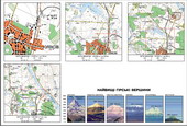
Dependence of the image on the scale of the map. The highest mountain peaks (compendium)

For the imagery used to plan out. Scale - is the degree of reduction of real objects. For example, model airplane, made on a scale of 1:100 will be 100 times less than the plane itself. The scale of the plan or map showing how many times the distance on the plan or map is less than the corresponding distance on the ground.

Typically, the scale indicate lower frame under the plan or map. The same scale can be expressed differently. Numeric (or numerical) is called the scale provided in the form of fractional numbers, the numerator of which unit, and the denominator - the number that indicates how many times the reduced image. For example: on the map scale 1:10 000 items all areas decreased in 10 000 times, ie 1 cm on the map corresponds to 10 000 cm on the ground. Distance on the ground made express in meters or kilometers, so convenient to say that this map at 1 cm 100 m It is for the convenience of the cards, but numerical, signed also named scale - verbal explanation of how many meters or kilometers area corresponds to 1 cm plan or map. To convert a numeric scale referred to in the denominator to reduce the numerical scale (cross out a few zeros). Therefore, if we want to explain how meter area of 1 cm maps, the numerical scale reducing the denominator of 100 (crossed out two zeros) if the same distance on the ground should be expressed in miles, the denominator of a numeric scale of reducing by 10 000 (crossed out 5 zeros). For example: 1:25 000 (1 cm to 250 m), 1:100 000 (1 cm to 1 km), 1:3 000 000 (1 cm to 30 km). To facilitate measurement of distances on the map sometimes used a linear scale. He is a straight line divided into equal parts, usually inches. One or two notches to the left of zero divide into smaller to get more accurate results. Digitizes scales according to scale. To determine the distance-measuring compass use, making his first leg to the edges of the desired section of the map, and then to a linear scale.

The more we reduce the use of the image area, the more land area, but with less detail can be represented. In other words, the larger the scale of the denominator, the smaller objects appear on the map. Plans and maps that contain small parts, usually is large scale. In accordance with established classification refers to large-scale plans and maps, 1 cm corresponds to 2 km area (up to 1:200 000). Maps, in 1 cm which contains from 2 to 10 km area (1:1000 to 000), belongs to medium-sized. A card on which is contained in 1 cm over 10 km area, known as small scale, such as hemispherical map scale 1:90 000 000 (1 cm in 900 km), Ukraine map scale 1:3 500 000 (1 cm to 35 km) .