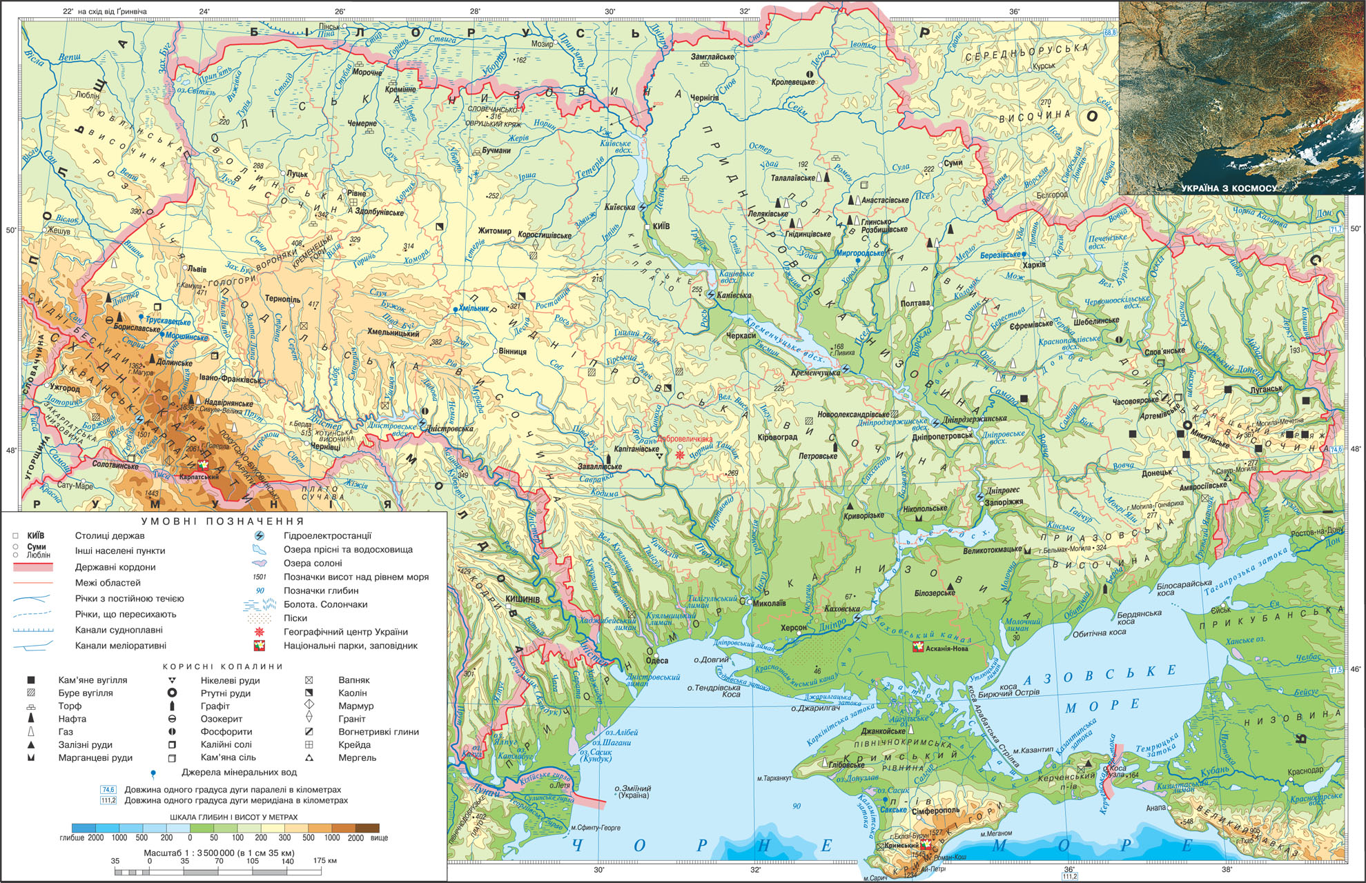
Geographical maps enable us to visualize the location of objects to determine their geographic coordinates, absolute and relative height and distance between them.
To determine the coordinates using grid Degree. If an item is on the lines of degree grid, then simply define its coordinates. For example, the latitude of Kharkov is 50 ° Mon. Rd. and longitude of Nikolaev is 32 ° C. d. If the object is located outside the grid lines of degree, then its coordinates determined by interpolation - comparing the distance to the nearest parallels and meridians. For example, the city of Ivano-Frankivsk is located approximately equal distance between parallels 48 ° and 50 ° Mon. sh. So its latitude is 49 ° Mon. sh. Longitude of Dnepropetrovsk 35 °. on, as the distance from the city on the map to the meridian 34 ° and 36 ° C. d. about the same.
As is known, to determine the distance between objects using a scale. However, the distance can be defined and using degree grid. Knowing the difference of latitude, longitude or object in degrees, it is easy to determine the distance between them, multiplying the difference in distance in kilometers, contained in a 1 degree appropriate parallel or meridian. For example: longitude difference between the cities of Lviv and Kharkiv is approximately 12 °. In parallel to latitude 50 ° Mon. Rd., both of which are located near the city, 1 degree corresponds to 71.7 km (these values are signed on the eastern beyond parallels card). By simple calculation calculate the distance between Lviv and Kharkiv is about 860 km. Difference of latitude between the cities of Kyiv and Odessa is approximately 4 ° (50,5 ° Mon. Sh. - Kyiv latitude minus 46,5 ° Mon. Sh. - Latitude of Odessa). As you know, by 1 degree meridian corresponds to about 111.3 km as the distance between Kyiv and Odessa is about 450 km.
Physical map makes it possible to determine the height of objects displayed on it. The absolute height of many objects on the map with numbers in black and deep seas - blue. Analyzing the physical map of Ukraine, determines that the highest peak in our country - Goverla has a height of 2061 m above sea level and the highest peak of the Crimean mountains - Mount Roman-Kosh - the height of 1545 m. But in order to determine the absolute height of any area should be colors that reflected relief, to compare with the scale heights and depths. For example, this map around Kyiv painted colors that match the height of 50 m to 200 m, Kherson and Zaporizhia - 50 m, Ternopil and Khmelnytsky - from 300 m to 500 m.
SHELL OF THE EARTH


 English