§ 8. Modern Geographical Research
That currently studying geography.More than 5 thousand years there has knowledge of the Earth. People penetrated into the depths of oceans, climbed the highest mountains, beat the most stringent desert. They have mastered space. The map has no more "white spots. Geography begun to study in schools and universities. The world is in the same notion of different nations, that formed the overall view of the Earth. In this - the main result of all previous cognitions of our planet. May be a view, that geographers are already known.
Yes the opening of new lands has passed. However, not all unraveled the mystery of the Earth. In modern era (from the second half of the twentieth century.) geographers not only know the laws nature, but also think about converting it for the benefit of people without harm to itself Nature. They proceeded to explain linkages between phenomena and processes. Geography of descriptive science into aexplanatory.
In Nowadays, scientists are exploring the land, oceans, atmosphere. Work is being carried on scientific stations, expeditions, outer space using sophisticated devices.
Man and nature.In the twentieth century. scope of economic activity has increased as people that became noticeable in around the globe. Its continents girded railways and roads, cut channels. The use of natural resources has become very fast and in huge sizes. Stepping planet, people often leave unpleasant traces: cut down forests, depleted soils, poisoned rivers, polluted air. Instead, conditions life are harsh and sometimes harmful.
So now the primary task of geography is the prediction of changes in nature due heterogeneous interference with her people. Geographers must develop guidelines correct, wise use of nature and its conservation.
Research World Ocean.Water space exploring scientific expedition. Patients previously opened unknown underwater ridges, islands and deep trenches. In 1957 expedition on board? Knight "in the Pacific expressed the deepest oceanic Trench -Marianasgutter(11 022 m). Later SwissJeanPicardand AmericanDonald Bergstrombathyscaphe sunk in the bottom of the cavity.
Securities information flow in the Arctic Ocean drifting give (those that moved). Such stations are arranged in large ice cake. Together with her they slowly float downwind or downstream without any engine. Drifting station equipped with special devices for observation.
Known French explorer of the sea depthsJacques-Yves Cousteaumuch of his life spent under water, studying the living world seas and oceans.
Now many of the world oceans to explore the use of their resources. What kind of treasures hidden water? First of all, it - oil and natural gas, iron and manganese ore. Deposits of these minerals in many open seas.
Research atmosphere.Economic activity and life largely depends on the state aerial shell of our planet - atmosphere. To monitor its condition in many areas of the globe is a meteorological station. Based their data, predict the weather. Especially important to anticipate such adverse for human phenomena such as thunderstorms, hail, storms. This allows at least some measure to protect against them.
Important presently are studying the atmosphere to prevent pollution. Polluted emissions of air transport enterprises and is very harmful for health.
Research in Antarctica.Regular research conducted in Antarctica since 1956 on the mainland and adjacent islands and countries of the world equipped research station. On one of them -station "Akademik Vernadsky" -since 1996, holds research andUkraine.
In connection with the study of Antarctica has been signed international agreement under which on this continent denied any economic activity and location military bases. Because Antarctica is called mainland scholars.
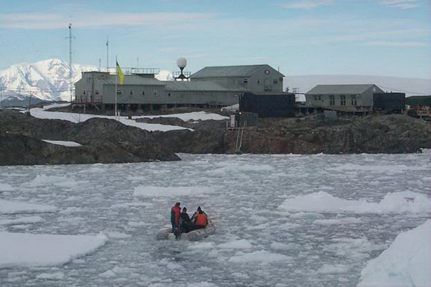
Fig. Ukrainian scientific station "Academician Vernadsky, Antarctica
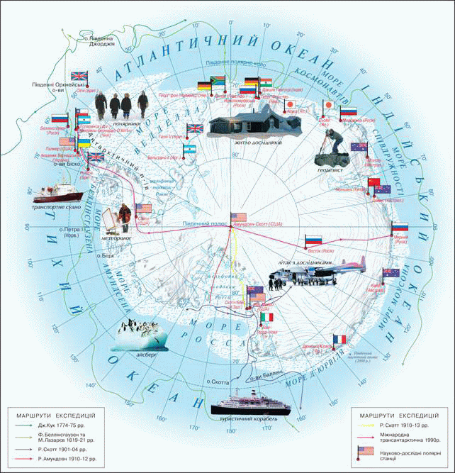
Fig. Antarctic Research
Research Earth.In 1957, earthlings launched into space the first artificial Earth satellite, and then ship with the first person on board. Since then, the space era began in the study of the Earth world.UkraineSpace is also state. It launched two spacecraft. In 1997 a citizen UkraineLeonid Kadenyukflew into space as part of international crew of U.S. space shuttle "Columbia."
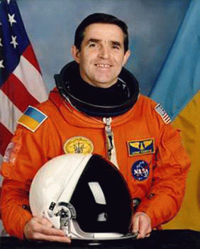
Fig. Leonid Kadenyuk
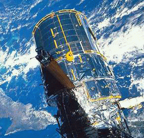
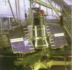
Space sets, that explore the Earth, equipped with special devices for photography by which the receiving satellite pictures. Analyzing them, people can immediately cast a look immense earth. From the height was seen major features of the structure of our planet. On the surface it is simply impossible identified. From the space could look at the hard to reach corners of the Earth: high mountains, polar regions, oceans, space, forests and deserts. Spacecraft used for observation of natural phenomena: volcanic eruptions, spills rivers, climb snow avalanches, storms. Photos quickly and most importantly safely convey information about the disaster area. Meteorological satellites "inspect" the Earth and determine the nature of clouds, snow distribution cover. Landsat images help zavbachuvaty weather, find the field minerals, to determine the size of pollution of surface. There is no doubt that we are on the threshold of a new era of great discoveries: Space space and with it their planet.
|
Fig. Shooting ground spacecraft |
Fig. Universal orbital station, established domestic PA?? Pivdenmash??and CB?? South??
|
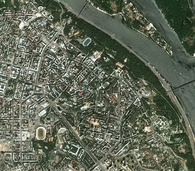
Fig. Kosmos Central part of Kyiv
Research Ukrainian scientists. In the twentieth century. Ukraine had known scientists, geographers. With their names associated formation of Ukrainian geography.
Paul Tutkovskyresearched and wrote the character of Ukraine Works on Geology and Landscape. Much attention he paid studies.Stephen Rudnytskystudied the natural features of our country. Scientist laid the foundation Political Geography of Ukraine. In 1918 Rudnytsky was first wall maps Ukraine and wrote books for children "Ukraine - our native land."
ConstantineRoach - Ukrainian economic geographer. He studied natural resources and made a detailed description of Ukraine.KalenykHerenchuk investigated relief and landscapes. Many of his works are devoted to problems of environmental protection.
In Nowadays Ukraine exercise Geographical Research scientists who work in Institute of Geography of the National Academy of Sciences of Ukraine and in universities.
International Earth exploration.His huge success in the modern time owes international geography cooperation. Especially for studies of the oceans, Antarctica, outer space.
Yes From 1957-1958 he scientists around the world joined forces to study the Earth and earth space. This year was named the International Geophysical Year. During this period the Soviet Union launched the first artificial satellite Earth, appeared geophysical research rockets in theU.S., Australia, Canada, France, Japan. With the advent of signs of contamination Earth scientists to join efforts becomes even more necessary. Together geographers different countries continue to explore Earth.
 Questions and Tasks
1. Studying modern geography?
2. What aggravated the relations of man and nature?
3. Why is it important to explore the oceans?
4. Justify the necessity of studying the state of the atmosphere.
5. What research conducted in Antarctica?
6. How does Landsat images to study the Earth?
7. Tell us about the geographical research of famous Ukrainian scientists.
 English