§ 10. Plan area
Image area.Picture of the Earth surface are needed to examine the nature and conduct of economy. A small area of the area can be drawn or photograph. Picture and photographnormally do from the ground. Because they are closer objects obstruct that is behind them. And the picture, and picture give an idea of locality, but they do not see that the size and shape has a whole lot.
Placed on the surface of objects (Forests, rivers, villages, fields, etc.) be seen better if the plot photograph above such as aircraft. Such imagery is called aerofotoznimok. It objects similar to their actual appearance on the ground, see their size and relative position.
View from above the surface and transmits plan area. But between him and topographicThere are many differences. Plan area - is drawing on paper, that depicts a small area of land surface in reduced size. From other pictures surface plan differs in that all objects and displays the notation.
Conventional signs plan, the first simple, second, different one on one third, like most things. Under these conditions, they are understandable to everyone who reads the plan. Thus, rivers and lakes shown in blue water, and forests - green - the color of vegetation. Lana (Field), vegetable gardens have a special character, so such areas to leave white terms. Sign bows like stalks of grass. Sands shows brown dots. Small streams, roads, narrow streets, depicting the notation as lines. These signs are generally conventional. They are used to All location plans.
By comparing the picture, aerofotoznimokand plan, we see that they are all miniature image of the earth's surface. Plan areas differs because he displays those items that are not visible on figure and aerial photos. According to the plans can be found names of villages, rivers, species of trees in the forest. Therefore, the plan gives more information, so it easier to learn and use areas.
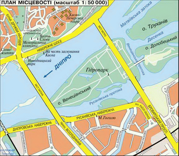
Fig. Plan 1:50000 scale terrain
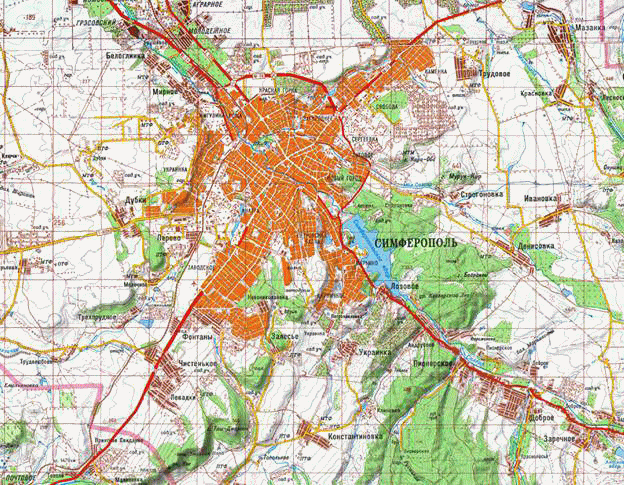
Fig. Plan area scale 1:100000
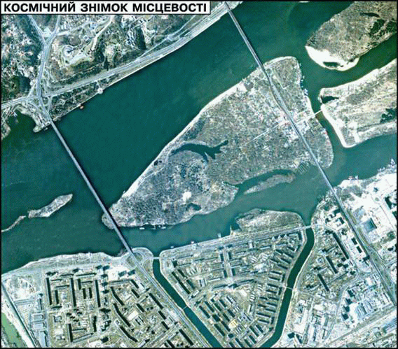
Fig. Space photo
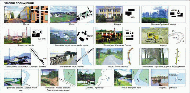
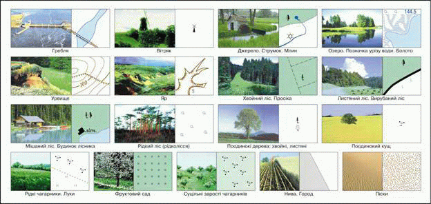
Fig. Conventional signs of a site plan
Determination directions on the plan. To find out where objects are located on the plan, should be able to determine trends on it. In the north area plans often arrow mark. Knowing the direction to the north, can be from anywhere plan, as the terrain, identify all other parties horizon. If the plan arrow is shown, it is assumed that the top edge of the plan - northern, lower - South, left - western right - east. Thus, the closer the object to top of the plan, the farther north it is located. Party horizon take into account when determining the position of objects on larger territories. For example, Kyiv located in the north Ukraine, City Yalta - In the south Crimean Peninsula. In areas also produce the parts of settlements. To do this, find the center of the city depicted on the plan or village. And part of it, which is directed from the center to the north, will northern, on south - south and so on.
According to the plans determine where to build factories and to build houses. They visible, convenient place where schools and places that bring him in gardens and parks.
Plans There is too much. The simplest of them, which shows only single objects, called schemes. These are, for example, schemes of railways, which can be seen at railway stations or on trains. They help you navigate to host plants. There are plans to schema in your school. On case of fire or other disaster to help them find ways out of premises.
Plans necessary areas to tourists. Going on a trip, followed by pre- acquainted with the area of travel. When used as plans hikes guides to targeted areas.
 Questions and Tasks
1. What is the plan area is different from them?
2. Tell the plan area that can be seen when going from town .... on Road to the north.
3. What items on the plan area located north of the windmill, and what - to west of it?
4. In what direction in terms of building area forester is the source?
5. What plans are needed to man the area?
6. Make a plan in scale 1: 10 000 for a description. From the school students were at 300 m north and reached the lonely oak. They then turned south-east and, passing 100 meters, were the well. More prolih their way eastward, and through 200 m they reached the lake shore. Then students headed south west to the mill, which stood at a distance of 200 m. After 50 m south students took to the road that led to the school. In what direction and what distance you want get students to return to school?
 English