§ 14. Geographical maps
The concept of the geographical map. As you know, the card was still BC. Since geography it accumulated data sets. Information on the map "recorded" in a special way. Mapping language - a language different in form, size and color signs, symbols. It allows you to convey geographical facts, descriptions, patterns of short, graphic way. But it does not prevent the map be easy to open - to understand the placement of objects in space. So maps "tell" about the structure of the earth's crust, spreading animal accommodation industry. Therefore they are called second language geography. Understand language maps without translation people who speak different languages. Any geographical study area begins with a thorough examination of her cards. Lo why geography should understand them. It is equally important to learn to read map and every educated person to be able to use it for their needs.
On Unlike aerial photos і plan, show on map large parts of the Earth or its entire surface. To put on paper images of such large areas, have to give it a miniature form. Therefore, map scale, compared with projections considerably smaller (in 1 cm - hundreds of kilometers). Because of this on map can not give such details and details of how to plan. With strong reduced they just disappear, disappear. Thus, the differences and maps plan arising from the size of the depicted surface.
Significant there are differences between the card and the globe. If the Globe gives a volumetric image Earth, the map - flat. Globe disadvantage is that it shows only that part which returned to observer. Same map shows the entire surface of the Earth simultaneously. Map More on the Globe. It can play some great areas of the earth surface (eg, ocean or continent, country or even part of it). Thus, geographical map - Thumbnail image and a generalized land surface on the plane, which is composed to some extent by using symbols. And the plan area and a map and a globe - the model surface.
 Interesting
geography
Interesting
geography
Map - Studying the Earth Tools
Of maps every geographical research begins and returns to the map, with map begins and ends with a map. Map is the most important tool for geographer. With its help he is preparing the study. In it, then puts his results, which in turn will serve to move forward. Map - This is a wonderful learning tool of the world that can give a person the gift predictions.
Julius Shokalskyy, Geographer, cartographer, oceanographer.
Misrepresentation on the map. If you try to open the Globe plane, the image surface in some places zimnetsya in folds, while others - broken. Just can not represent globular surface of the Earth on the map without distortion. The maps are distorted lines of length, area and shape of objects (Continents, oceans, seas, islands, etc.). Distortions of the map easily notice if you compare them with the image on the map. Yes, on the world map island Greenland with an area almost the same as Australia. Actually, and this visible on the map, Greenland is less than 3,5 times in Australia.
The smallest distortion on the world map will be near equator. Towards the poles they grow. Misrepresentation of the stronger than most of Earth's surface is shown on the map and smaller than its scale. Misrepresentation is available on all maps, so very accurate with them, as in the plans area it is not possible.
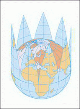
Fig. The surface of the globe, cut into strips
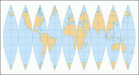
Fig. World Map, derived from a globe cut in strips
Legend maps. Without knowledge of how letters can not be read book, so without the knowledge of symbols can not be "read" to understand image map. Map always requires deciphering the signs that used to it. Explanation of symbols taken out on field maps and called Legend. Legend easier to read content cards. To show objects on the map there are different ways of maps. Conventional signs thus differ in form, size, color. They can be expressed in scale and can be and pozamasshtabnymy.
Method icon - Identification of objects and phenomena specific icons that indicate their location. Badges are not expressed on a scale map. For example, icons indicate the location of minerals.
Method habitats area shows the spread of certain objects. For indicate this on the map outline area and spreading paint over its color. It shows the species of animals, crops, human races and more.
Linear marks transfer to map objects in the form of lines: the river boundaries of the road. Their length is in scale and breadth - out of scope.
Traffic Signs used to show movements of different phenomena: sea currents, winds, transport (they show arrows).
Isolines - Lines of equal values of any Score- maps depict terrain (horizontal) temperature (isotherms), rainfall, atmospheric pressure and so on.
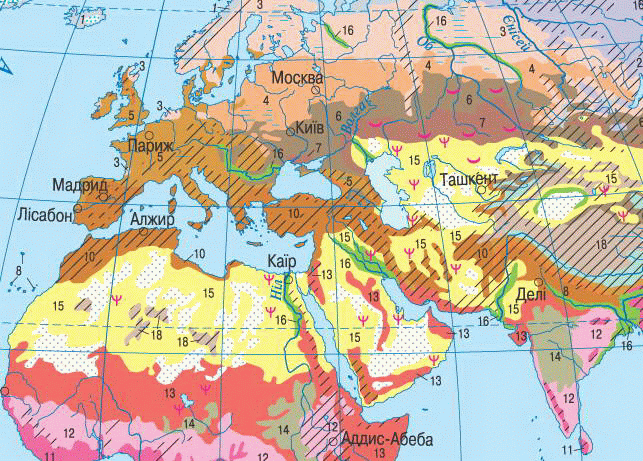
Colors are also characteristic of symbols. Some objects can be shown layer coloration. This way, the maps show along with the contoured relief. Maps. In contrast to the plans, not horizontally held several meters and hundreds of meters across and through different periods of height (in map hemispheres - 0, 200 m, 500 m, 2000 m, 3000 m, 5000 m). For greater visibility contour plot zafarbovuyutsya different colors: areas with heights from 0 to 200 m - green, 200 to 500 m - yellow, 500 m - shades of brown. And shades of blue shows the oceans, seas and lakes. The darker the color, the deeper the sea and oceans. Colors used on the map to indicate the relief, explains scale heights and depths. It is for all physical map and allows you to easily identify where the high land areas and where - low, where - deep plot sea and ocean, and where - shallow. Top height and depth on the map indicate figures in meters.
a) Icons
b) linear (source)
c) qualitative background (soil)
d) Isolines
e) Surfaces
g) A traffic sign (arrow)
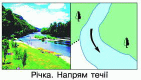
Fig. Map symbols
Types map scale. On all maps, as well as the plans and globes, specified scope. In Depending on the scale are three groups of cards:
1) large- 1: 10 000 to 1: 200 000;
2) medium-sized- 1: 200 000 to 1: 1 000 000;
3)small-scale - 1: 1 000 000 and smaller.
More dribnomasshtabnoyu and will map to a size reduction compared to the map more terrain. Large zahalnoheohrafichnimaps are called topographic. They show relatively small areas surface with the same detail and reflect the basic objects (terrain, water, vegetation, human settlements, commercial facilities, roads, borders). They very little distortion.
On surface maps depicted in a reduced size. All details are in Indeed, it is impossible to show. Therefore show only the essential objects, ie image generalize. What smaller scale maps, the more generalized image.
Interesting geography
Scale and dokladnist image
Image 1 km2 areas on a scale of 1: 1000 is 1 m2 maps in scale 1: 10 000 - 1 dm2In scale 1: 100 000 - 1 cm2, On a scale of 1: 1 000 000 - 1 mm2. Clearly, if the scale of 1: 1 000 small plot field can be represented with all the details, then scale 1: 1 000 000 it will look almost period.
Map - Great invention of mankind. Maps - important source of geographical knowledge. Skill work with them, you can explore the world: nature, people and economy different territories. In addition to cognitive, maps, and have great practical value. By maps establish the most suitable places to build cities, canals, power stations, a pipeline, railways, highways. Geologists outline areas for their search for mineral deposits. Without the card could not swim ships and planes to fly, that initially draw routes on maps. They need to target areas in tourist trekking and expeditions. Three-hour forecast maps are created, to help her zavbachuvaty. There is a medical card, which shows areas of distribution certain diseases. The more scientists study the maps, the more surprised diversity of its scope - from schonaybudennishyh trouble to research predictions.
Interesting
geography
About value cards once and now
Known the maps of ancient China were the instruments of dominion. They conducted archival business, diplomatic and military documents, and was the tax system. Their ritual role confirmed by the fact that they adorn the tomb rulers. The work was compared to the work of cartographer krasnopystsya, artist or scientist. Now the ancient historians studying maps, where various peoples live in past, where the borders of the trade routes and ran. So they learn what changes have taken place in nature and in society.
 Questions and Tasks
1. What are the common and different features of the plan area have and a map?
2. What are the advantages compared with maps of the globe? In What disadvantages?
Why does the earth's surface image on the map there distortion?
3. Which means the maps show different items and effects?
4. For hemispherical map define the absolute height of Amazon lowland Tibet Labrador Peninsula.
5. For a map defining the maximum depth of the hemispheres and the Northern Japan Sea
6. With physical map of Ukraine, define what the absolute height of a regional center your area.
7. Find a map of Ukraine on the Black and Azov seas. Which of them deeper?
8. How to change altitude Goverla if the water level in the Baltic Sea rose by 10 meters?
9. What are map scale?
10. What do the maps to life and business Rights?
11. Over the map of Ukraine define the distance from your regional center in Kyiv.
12. Determine the scale of maps, in which the distance between two points in 10 km equals: a) 1 cm; b) 5 cm; c) 10 cm
 English