§ 43. Flow
"Rivers" in the seas and oceans. Species water movement in the World Ocean currents are. This horizontal movement of water in the form of broad streams. Although the ocean flow and are not banks, they are often compared with rivers.
Home cause of their formation - constant winds. Most current and is called - current Western Winds. It forms a long range of 30 thousand km dovkruzh Antarctica. Width of flow - a few miles, speed - 3 km / hr. Compare with most river of Ukraine - the Dnieper, the total length is only 2201 km and width within Kyiv - 400-600 m.
Warm and cold currents. The temperature of the flow considered relative to surrounding waters. Heat flowis the water temperature a few degrees higher than the surrounding oceanic water. Cold flow - Contrary. Warm currents usually traveling from warmer to colder latitudes, cold - on the contrary. You already know that significantly affect the current climate of coastal zones. Thus, heat flow increase the temperature by 3-5 0C and increase the number of precipitation. Cold temperatures reduce the flow and reduce rainfall. On geographical maps showing the current warm red arrows, cold - blue.
Most heat flow - Gulfstream. It runs in the Atlantic Ocean and heading from the eastern shores of North America to Europe. Its length - three thousand miles in width - Over 100 km, velocity - up to 10 mph. This current heats the coast Scandinavian peninsula, which without it would be turned to ice desert. Not accidentally warm current called the "water heating" of the world. Air masses that form over warm Gulf Stream, heat, moisture saturated and bring heavy rainfall in Europe. Nearby 450 пн. sh. Gulf Stream enters the North flowUnder the influence of which Barents Sea does not freeze. In the Pacific Ocean near the coast of South America is cold Peruvian current. The air mass that formed over its cold waters, not saturated with moisture and do not bring rain to dry land. Consequently, on the coast in some years there is no rain, and this fact contributed of there Desert Atacama.
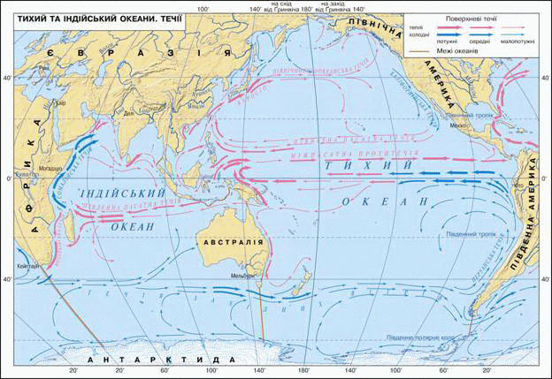
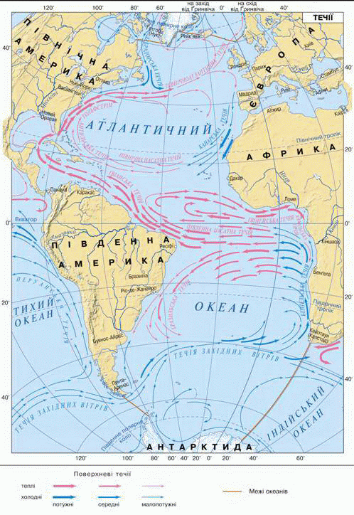
Fig. Warm and cold currents on a map
The movement of currents.Since the main reason for the formation of the water flow is constant winds then their movement in the Pacific Ocean roughly corresponds to the movement of air masses. However, their movement also affect the power of rejecting the Earth's rotation around its axis and shape of continents. Thus, permanent pasatni winds blowing in both hemispheres 30-x latitudes to the equator, forming a powerful North Pasatnu і South Pasatnu flow. These trends across the ocean from east to west. Natrapyvshy on coasts of continents, flow rozdvoyuyutsya and rejected by south and north. This created new current, passing back - from west to east. At their direction in temperate latitudes persistent winds affecting western and deflective strength of the Earth's rotation. Thus in both hemispheres in the ocean there are two circuit. In the Northern Hemisphere flow form a vicious circle and moving clockwise in the South - opposed.
Oceanic currents play an enormous role in the distribution of heat around the globe. They tolerate not only heat but also salt and organisms that live in the ocean.
Water supply. Large volumes of water that formed in some areas Oceans and different from each other, temperature, salinity, transparency, oxygen content and other properties, called water masses. Depending on the geographic latitude distinguish water masses equatorial, tropical, moderate, polar. They actively interact with the atmosphere: give her warmth, her absorption of carbon dioxide and produce oxygen.
 FAQ
task
FAQ
task
1. What makes the flow of water movement at the waves?
2. Describe the route map for bottles message, which threw the boat in the Strait Drake.
3. What is the perimeter and more accurate correct: "Wind - that drives the ocean" or "The sun - that moves water Ocean?
4. Explain why the Peruvian flow with water temperature 22 0C is called cold, with temperature and North Atlantic 2 0C - warm.
5. Why Gulfstream called "models" of Europe?
6. Nature Rev. Svalbard slightly different from the nature other Arctic islands. There's warmer, more snow falls, there is vegetation. What explained?
7. Famous Norwegian traveler Tour Heyyerdal made sailing on the raft papirusnomu "Kon-Tiki" off the coast of South America (120 AP. sh. 770 зх. on) to the islands Tuamotu (210AP. sh. 1350 зх. etc.). Follow Route his voyage on the map. Determining a movement flesh?
 English