WATER Sukhodol
Land waters include surface waters (rivers, lakes, swamps, glaciers, artificial ponds and canals) and ground. Surface water is an insignificant part of the hydrosphere of the Earth - about 0,02%. However, these water the most widely used man.
§ 45. Rivers
Remember that the river is in your area
What is a river. Of course, the river - Small or large - every seen. Small River called streams. Every river, every stream have leaked - place where they start. Source can be a source, swamps, lakes and even ice edge roztaye. YesDnipro begins with a mire on the Valdai Hills in Russia. Angara flows from Lake Baikal. Terek rises in the glaciers of Caucasus. The place where the river ends, that flows into another river, lake, ocean, called mouth. The distance between source and mouth length of river. Is the world's longest river Nile (6671 km), Europe -Volga (3 530 km), Ukraine - Dnipro(2 201 km). The largest rivers flowing into the world ocean or sea. Yes Nile flows into the Mediterranean Sea Amazon - The Atlantic Ocean.
Every river flows in the reduction, which runs from source to its mouth - is Rivers Valley. Holes in the river valley, which is constantly flowing water, called streambed (runway). Both sides of the river valley limit slopes. Each river has a right and left banks. Which of them is determined by the flow: if a face to where the river flows - the stream, then right to left shore, and left - left. Typically rivers flow permanently. But there are others temporarily dry up. Thus, river- A stream of water flowing through the cavity produced by him.
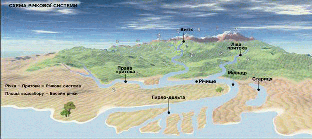
Fig. Scheme of structure of river system
River system and river basin. Each river has tributaries- Rivers that flow into it. And where b river was not started, due to the influx, it becomes broader and povnovodnishoyu. Yes, right tributary of the Dnieper - Pripyat almost doubles the amount of water in it. Tributaries ofazvychay shorter, the main river. Main river with all its tributaries is called river system.
Jets, rivulets and rivers carry their waters to the main river. And they flow down sewers, thawed and ground water from a huge area. The area from which all water drains the river is called River Basin. Pool includes the main river basins of its tributaries, covers an area that is land occupied by the river system. The largest river basin in the world has Amazon. Its area - 7 million km2, Which equals the area of mainland Australia. Boundary that separates adjacent river basins, is called watershed. In the mountains divide runs along the ridge crests, the Plains - on top of their fields. So, on one side of the watershed water flowing in one river to another - to another.
Nutrition rivers. Rivers fed by rain, talymy snow and ice and groundwater waters. From power supply depends on the amount of water and changing its level in a river. Mainly rain water feed rivers in areas with hot and humid climate. Such supplies are most flowing rivers of the world - Amazon and Congo. The water level in almost unchanged, as heavy rains fall in their pools year round. Talymy snow і glacial waters feed river the origins of which are high in the mountains, where peaks are covered with glaciers. Highest water level in these rivers - the summer, when melting glaciers. Such power has Amu. There are rivers that have mixed feed: and rain and snow talymy and groundwater. This power should River temperate latitudes. In winter, when they covered with ice, the only power source - Output of groundwater in their bed. In spring, they are replenished talymy snow waters and summer - rain and underground. Consequently, river depends on the climate of areas they flow. Naypovnovodnishoyuriver on Earth is Amazon, which is mainly rain supply. It makes every second in the Atlantic Ocean 120 thousand m3 of water. The amount of water would fit in 1500 rail tankers.
Level water Rivers year changing. In Ukraine, for example, the water level rises in the rivers in spring, when they thawed snow flowing water. The water will overflow and fill the bottom channel Valley. Spring is coming flood. Plot the bottom of the river valley, which floods every year during the flood, called flood bed. In summer, when strong evaporation occurs, the water level falls. Comes middle of summer - The lowest level of water in a river. Autumn evaporation decreases, but due to rains in the river water and it comes level increases. In winter there is almost no rain, and rivers are fed only groundwater. Therefore, as in the summer, the water level decreases and again reached middle of summer. At that time comes freezing - River are covered with real ice cover. In any season, heavy rains may cause flooding - Sudden raising the water level. Such regular changes in water level during the year called water regime of the river.

FAQ task
1. What river is called? What is a leak and mouth?
2. What river system?
3. What is called river basin and watershed?
4. How does the water level in the river throughout the year?
5. With physical map, determine which river - the Dnieper, the Amazon or the Congo - has more river system.
6. Define Maps for the position of one of the rivers (optional):
a) where the mainland and in which part flows;
b) where located on the major forms of relief;
b) begins where the direction is flowing and where falls;
d) is approximately the length of e) which has the largest tributaries.
7. Describe one of the rivers of the area under the plan:
1) Where Does the direction and flows where flows;
2) to the pool where the river (lake, sea) belongs;
3) length and width, average depth;
4) as dependent nature of the flow of relief (flat or mountainous, the presence of thresholds and waterfalls);
5) a river valley (broad or narrow, deep or shallow);
6) kinds of power;
7) particular regime;
8) major tributaries of the right and left;
9) How is human;
10) measures taken for protection.
 English