Oceans huge: in its salty waters shovano3 / 4 surface. This majestic, mysterious ocean perepoyasuye our whole world ipulsuye inflows, as if a huge heart of the Earth. Welcome nebezpechnekolyhannya while water like indicates living creature Ocean zachayilas in the dark depths? Writers write so eloquently about the oceans, which are subject vyvchennyaheohrafiyi.
Word ocean derived from the Phoenician "Pts", "very", which means huge, boundless. The ancient Babylonians and Egyptians Ocean nazyvalymifichnu river, which according to their beliefs omyvala all the land, which nibytorozmischuvavsya on a flat disk.
Surface Ocean - 178, 7 million км2.
Average depth - 4 000 m.
Maximum depth - 11 022 m.
1. Remember that the Earth's oceans with the largest by area.
2. Who when the first seafarers crossed the Pacific Ocean?
3. What landforms are distinguished by ocean bottom?
Geographical location and DIMENSIONS. Pacific Ocean called Portuguese Ferdinand Magellan during the first circumnavigation. In fact, this name does not match the character of the ocean, as it typical frequent storms and hurricanes. Magellan just lucky with the weather - he managed to cross the Pacific Ocean, never got into the storm. So to map a new name, Spanish Mar Patsyfiko - "More peaceful, quiet, calm.
Geo position - important characteristics of any ocean. It is - it kind of address in the space. From the location dependent natural conditions area. Learn to help determine the geographic location Plan (Table. 1).
Table 1
Characteristic geographical location of ocean
|
Plan |
Actions |
|
1. Provisions concerning continents
|
Determine between which is located mainlands |
|
2. Provisions concerning other Oceans |
Set, which borders on oceans
|
|
3. Provisions concerning the equator
|
Set, which is hemisphere (North or South)
|
|
4. Provisions concerning climatic zones
|
Set in climatic zones which extends |
|
5. Features coastline |
Define: a) strongly or weakly divided; b) which relate to the ocean sea; c) that in the dry bay resort; d) that large islands located in the ocean |
Pacific Ocean located between Australia and Eurasia West, North and South America - the East Antarctica - the South. The banks of these continents is beyond the ocean. Equator divides the Pacific into two approximately equal parts, as in northern and southern ocean similar nature. It is for all climatic zones except the Arctic.
Pacific Ocean - the largest and deepest of our Oceans planet. He is so huge that can contain in itself all continents and islands Earth. It covers almost half the area of the oceans.
In the Pacific include many seas. Among them okrayinni Sea - Bering, Okhotsk, Japan, Pivdennokytayske. They are located along the eastern margin of Eurasia, was resort in the dry and separated from the ocean only peninsulas and islands. Philippine Sea located between islands. The largest bays are Alaskaand California. Straits connecting the Pacific other oceans: Drake and Magellanic - From the Atlantic, Malacca - From Indian, Bering – from the Arctic. Pacific and Atlantic oceans are connected and manmade Panama CanalThey made via the Panama isthmus between North and South America. Islands in the Pacific Ocean a lot, and they have different origins: mainland (Japanese, Philippine), Volcanic (Marian) Coral (Tonga Islands).
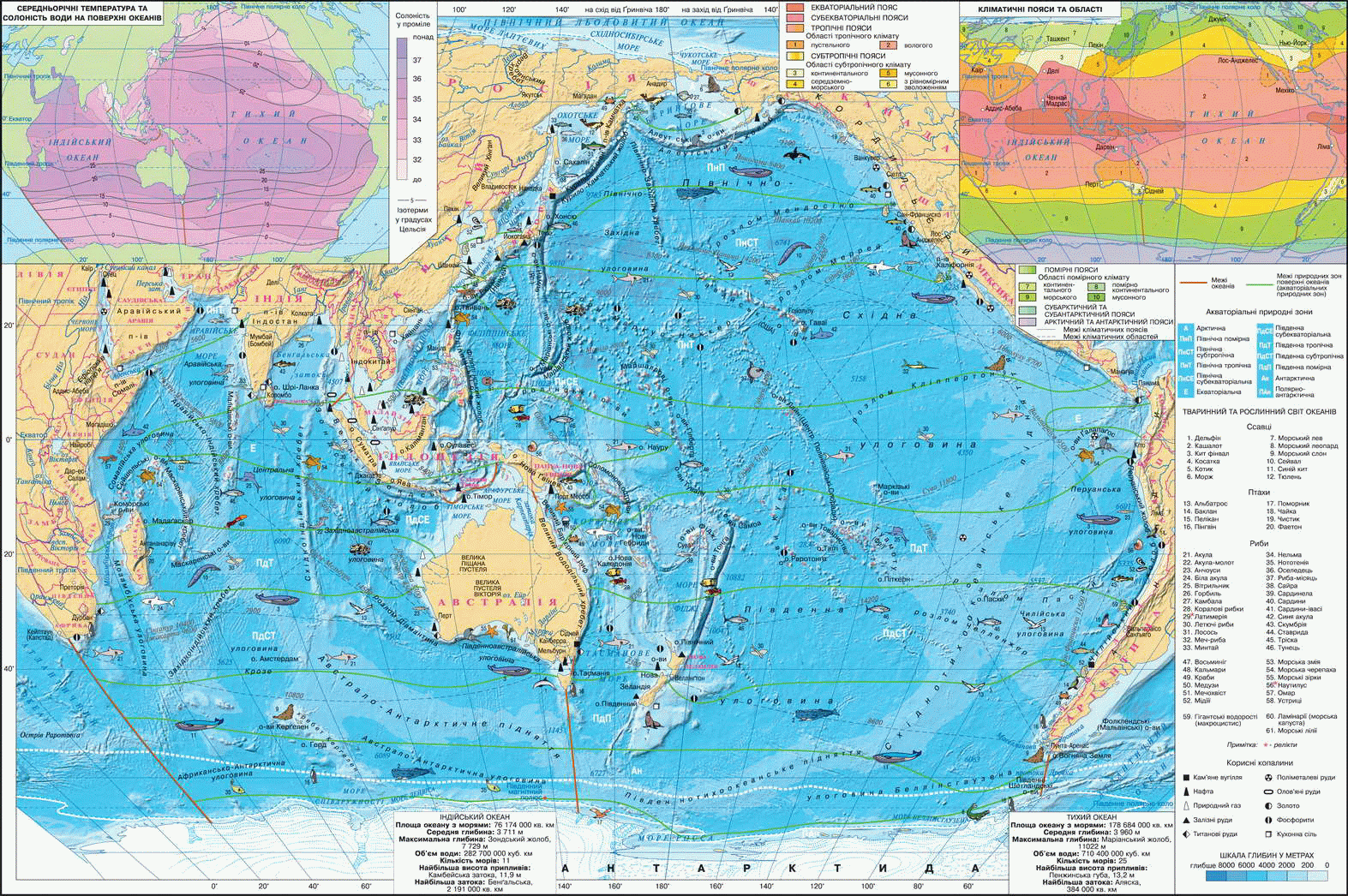
Fig. Pacific Ocean
Working with map
1. In which hemispheres is relatively Ocean equator and zero meridian?
2. Name the largest sea, bays and straits relating to the Pacific.
3. Name the largest peninsulas and islands of the Pacific.
4. Name of the Mid-ocean ridges-raising. What they are hollow share the bed of the ocean?
5. Name the islands are peaks of underwater volcanoes.
HISTORY STUDY. Sailing the Pacific Ocean have been carried out in ancient times, the indigenous inhabitants of the island. In the XII century. western part of the ocean mastered Chinese. History Europeans began its investigation, probably with discovery that made the Spaniard Vasco Nunez de Balboa. In 1513 he crossed the Isthmus of Panama and Central America from the top of the mountain saw vast expanses of water, which called the South Sea. By the time Europeans were sure that there is only one ocean - the Atlantic.
Ferdinand Magellan and his team were the first Europeans who crossed the Pacific Ocean during the first circumnavigation in 1519 - 1521 After them he was Spanish, Portuguese, Dutch, British carried out a number expeditions for exploration of the way through to the Pacific coast of Asia. Then it was opened many islands. Also recorded in marine pilots logs information about winds, currents, tides and ebb, and other important information. Interestingly, Magellan tried to measure the depth of the Pacific, but 762 m lowering hemp rope, the bottom has not reached. Details flora and fauna of coasts and coastal waters were collected separately.
In XVIIIth. Russian expedition led Vitus Bering and Alex Chirikova (Which, incidentally, was born in Kiev) collected scientific material about the inhabitants of the North Pacific Ocean. Most famous ocean explorer was English navigator James Cook, who brought the card to many Pacific islands. The first measurements of surface temperature and depth were made at the beginning Nineteenth century. during the circumnavigation John Kruzenshtern and George Lysyansky.
In 1873 - 1876 English expedition to рр. ship "Challenger" collected information about various features of the Pacific waters Ocean. For the first time the map was drawn up and its depths revealed deep gutters. Later studies were made on special research vessels - "Knight" (1886 - 1889's, Russia) "Albatross" (1888 - 1905's, U.S.) And others.
Nowadays, scientists from different countries hold study the ocean floor, seismic zones, migration of industrial fish for using underwater vehicles - bathyscaphe and submarines. It was clarified depth, open unknown species of marine organisms, created new maps Ocean.

Interesting geography
Detachment Vasco Nu passed through forests and swamps and after various adventures crossed the modern Isthmus of Panama. One day he noticed the hill huge body of water. Distavshys coast, the Balboa as it was in clothes, entered the water from the flag in one hand and a sword - in the second, and solemnly declared that Ocean property of the Spanish king.
Interesting geographyThe first-ever regular sea connections
After Magellan's Voyage around the World in 1573 Spaniards launched the first ever regular communication across the Pacific. Marine flights performed from the port of Acapulco in Mexico to Manila in Philippine Islands. The way there and back was 18 000 nautical miles. Swimming Philippines lasted for 60 days. In the opposite direction it was much longer and dangerous, as the sailboat had to take into account the prevailing winds. These flights lasted 238 years and performed with exceptional punctuality! And this at a time when floated on a compass and maps very close, when everything depended on winds, currents, typhoons, not to mention the heat, and scurvy pirates!
DNA structure and relief. By the variety of bottom relief ocean surface does not yield land. On distinguish ocean bottom margin continent transition zone, the bed and the Mid-ocean ridges. Bevel the bottom of the Pacific Ocean determines only Pacific plate. Together with other plates, it makes horizontal movements, accompanied by submarine and terrestrial earthquakes and volcanic eruptions.
Margin Continents in Pacific has a narrow shelf (shelf) and the steep, heavily dissected gully marginal.
У transition zone, lying between the continental margin and lozhem ocean crust Mainland-type moves in oceanic crust type. They are located okrayinnyh hollow seas, island arcs and deep troughs. Island arcs - A chain of islands created huge arched submarine ridges, some of which peaks rise above the water. These are, for example, Kuril, Japanese Islands. Deep gutters - Narrow and very deep (up to 11 thousand meters) flexural deformations of the ocean floor. They frame separating the island arcs and transitional zones of the ocean bed. In the Pacific Ocean placed most of the deep trenches of the oceans. The most fundamental of They have Marianas (11 022 m) Philippine (10 265 m).
Bed located at depths of 3000 - 6 000 m and covers most of the bottom area of the Pacific. He characterized thin oceanic crust. Relief bed - a combination of depression and underwater mountain ridges that divide them. Basin floor is huge reductions and have hilly or flat surface. Underwater mountain ranges are formed by volcanoes. For example, Northwest ridge dividing North West and North-East basin. Mid-ocean ranges - A huge underwater mountain building, formed of frozen bench where differences lithospheric plates. Two of these ranges go on south and east of the Pacific - Pivdennotyhookeanske and Shidnotyhookeanske raising. Sometimes peaks rise above the ocean in the form of volcanic islands. So Ocean forth dry land. Udovzh ocean boundaries are seismic zone Pacific ring of fire.
Interesting geography
Can Pacific Ocean impaired?
It is believed that approximately 50 million years due to movement lithospheric plates Quiet reduced in size. Instead Atlantic area and Indian oceans grow. But this is only guess that needs clarification.

Questions and Tasks
1. Using the card, describe the geographic location Pacific.
2. Who and when examined the Pacific Ocean?
3. Tell us about the specifics of the transition zone of the bottom of the Pacific Ocean.
4. What a relief sea floor?
5. Think about why many in the Pacific islands volcanic origin.
6. By degree grid maps calculate the length of the Pacific from west to east on equator (1
Practical work
Sign on contour map Name Seas - Bering, Okhotsk, Japan, Pivdennokytayske, Philippine; ducts - Bering, Magellan, the channel - Panama; deep trenches - Marianas, Philippine, Islands - Hawaii, Mariana, Japanese, Philippine, Big Sunda.
 English