§ 1. What and how studies geography of continents and oceans
1. Remember what the word "Geography".
2. From what sources can be obtained geographic information?
3. What are you known methods geographical research?
SUBJECT Studying geography continents and oceans. Studied geography of continents and oceans is the nature of our planet as a whole, its continents and oceans, and nations country.
Studying the individual continents and oceans, you know who and when they opened and explored and why are features of their nature: relief, climate, inland waters, vegetation and fauna. You expand your knowledge about the oceans and its role in forming the nature of the land and farm population.
Variety characterized not only by natural conditions, but population and economy. People work and live on the plains and mountains, including forests and steppe spaces in the cold tundra and hot deserts. They erected houses build factories, smelted metals, creating machines grow different plants bred animals. It also examines the geography of continents and oceans. So you expand their knowledge of the country located on the mainland, the life of the peoples who inhabit them.
This course is generally replenish your knowledge and the cover of the Earth: lithosphere, hydrosphere, atmosphere, biosphere and geographic - most complicated membrane, which we live and what must be kept.
Continent, PART OF THE WORLD, THE OCEAN. The entire surface area of Earth is 510 million km2. Of these, as you already know most of the busy waters of the oceans. His form 4 oceans – Silent; Atlantic, Indian, Arctic - And the sea.
Above the water are the six Continents – Eurasia, Africa, Australia, South America, North America, Antarctica. They are of different size and shape of the coastline. In the oceans, more nearby continents are placed much smaller area land - Islands.
All the dust of dry land is divided another 6 parts of the world: Europe Asia, Africa, America, Australia зOceania, Antarctica. Dismemberment of the world emerged historically in the course knowledge of humankind Earth. Divide the Earth also Old World (Europe, Asia and Africa) and New World (America). In the New World did not include Australia and Antarctica, though they are, as you recall, discovered much later. This division also historically formed and was associated with science.
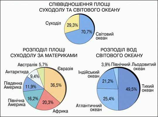
Fig. 1. Area of continents and oceans
SOURCES geographical knowledge. You already know that knowledge can be gleaned from different sources: gazetteer and encyclopedias, maps and atlases, magazines and newspapers.
For geography of continents and oceans rich source of knowledge can be telecast on the nature of different parts of our planet, the population and culture of different countries. At present the service users worldwide The Internet, through which you can very quickly get textual, cartographic, audio or video information.
Fig. Sources Geographic Information
Methods of Geographical Research. Some Methods - Research methods of various objects or natural phenomena and society - you learned in Grade 6. You already know about descriptive and expeditionary Methods. You learned about paleogeographic method, which allows the study of rocks, remnants of plants and animals to learn about the nature of ancient geological epochs. Mapping Method is to determine the location natural objects (rivers, lakes, mountain ranges), as well as cities and countries and applying them to the card.
There are many other methods of geographical research. For example, in the last century geographers use Aerospace method - study the Earth's surface for aerial photography, made from aircraft and space apparatus. Via design methodUsing computer equipment, provide for changes in the environment.
TYPES OF CARDS. By studying geography, you turn to various maps. Their many species. To properly use the card as an important source of information you need to know their purpose and main features. According to different features maps are divided into groups: the content, scale, coverage area
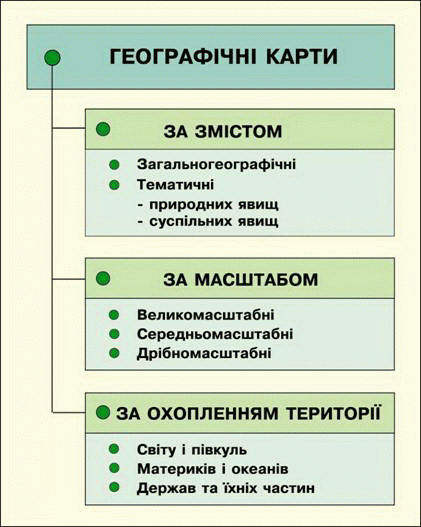
Fig.3 Classification of cards
By content maps divided into zahalnoheohrafichni and thematic. Zahalnoheohrafichni mapsdepict the general appearance of the surface. They show the same detail different items - and relief, and rivers and lakes, and settlements, and ways and others. These include familiar physical maps hemispheres of the world, continents, individual countries. Thematic maps Conversely, devoted to one topic, they shows a single component nature of population or economy. For example, topic maps can be soil, water, temperature, vegetation etc.. The remaining elements of maps (major cities, rivers, etc.) is only needed as background and landmarks.
ScaleAs you know, maps are divided into:
1) large (1: 10 000 to 1: 200 000);
2) medium-sized (1: 200 000 to 1: 1 000 000);
3) small-scale (1: 1 000 000 and smaller).
More dribnomasshtabnoyu and will map to a size reduction compared to the map more terrain.
For coverage areaThat portrayed maps are divided into:
1) map and hemispheres, Which shows the surface of the globe (They have the smallest scale, on their surface shows very generalized and schematic);
2) maps Continents and Oceans (They have larger scale than the map, but they are too small-scale);
3) maps of certain parts of continents - Countries, regions, districts (their much larger scale, as depicted surface details).
ATLAS And geographic information systems. In ancient times, Mr.and primitive maps, drawings, sketched by ancient inhabitants of our planet, the data were few. In our time the maps were "Overpopulated": they must be placed so that all the missing place.
Quite successfully overcame this problem atlases- Collection of different maps, placed in a certain order in one book. There World Atlas. In these maps show areas of ground at one point another. There are atlases of individual countries such as Ukraine, which contained various thematic maps of the same territory. There are educational atlases, such as for 7 class. They picked up maps that illustrate the major themes of the textbook. Maps think the invention of mankind. Ability to work with them to research world: nature, people and economies of different areas.
Now atlases was not enough for the flow of information needs of modern man. And it came to the aid of computers. In memory electronic computing machines are already known to enter data about the Earth's surface and add new, just come. So created Geographic Information System (GIS) - Summary of all data on the Earth. By such a system can quickly display everything that interested him, to combine in one image the different information.
 Questions and Tasks
1. What is the subject of study of geography continents and oceans?
2. Name the sources of geographical knowledge. What of them you had to use it?
3. Using methods which perform geographical research?
4. How to distinguish the cards by content?
4. What are map scale?
5. What are the maps for coverage in your area contains school atlas?
6. What are the common and different between hemispheres physical map and physical map of Ukraine?
7. What is different from the atlas maps?
8. What is GIS?
 English