§ 4. Climatic zones and region
1. Remember that called climate.
2. What are the main factors klimatotvirni.
3. What are the main features distinguish the transient and climatic zones?
CLIMATE AND CLIMATE ZONE. From the course you grade 6 But know that climate - Years of weather regime, typical for this area. Klimatotvirnymy factors are the amount of solar energy, circulation air masses and the nature of laying surface.
Climate Zones - Latitudinal bands that have relatively uniform climate. They different from each air temperature and prevailing air masses. Climatic zones vary zonally, ie from the equator to the poles. In each major climatic zonesprevails throughout the year or another air mass - equatorial respectively, tropical, temperate, Arctic (Antarctic). Transitional Zones subpoyasamy called - from the Latin "sub" means "under" that is under the body (subekvatorialnyy - pidekvatorialnyy, subtropical - pidtropichnyy etc.).. In the transitional climatic zone air masses coming from the neighboring main zones, varying with the seasons: summer air mass dominates the south of the main belt, and in winter - the north.
Within climatic zones are distinguished climatic region with different types of climate. Climatic region formed under the influence azonic (Not zonal) factors: the laying surface (or formed when continentalOr sea Climate type), Ocean currents (climate of Western and Eastern coasts of continents).
MAIN TYPES OF CLIMATE. At different latitudes influenced by factors klimatotvirnyh formed different climatic zones with a certain type climate.
Equatorial climate formed under influence equatorial air mass. It determines the hot and humid weather throughout the year. In equatorial latitudes set low pressure. Year-round temperature is kept high (24 ... 28 0C). Annual temperature amplitude quite small - 1-2 0S. Strong surface heating in these latitudes and extensive rise of warm air forms a powerful Cumulonimbus clouds. They offer daily rainfall with thunderstorms. Because precipitation during the year falls very much - more than 2 000 mm. Characteristic and high relative humidity. Seasons in this climate, no, Since both temperature and rainfall throughout the year almost change.
Subekvatorialnyy climate each hemisphere determined by seasonal changes of air masses. In summer, when the sun illuminates more Northern Hemisphere, comes equatorial air mass adjacent (south of) the equatorial zone. Therefore, summer hot and humid in the equatorial belt. In winter, when the sun illuminates more Southern Hemisphere, in this area comes tropical air mass adjacent (north) tropical zone. It defines hot and dry weather. In the Southern Hemisphere it is the opposite.
Tropical climate very hot and dry. It forms tropical air massThat prevails in tropical latitudes. They set high atmospheric pressure. The temperature in summer is 35 0C and winter reduced to 20 0C. The daily temperature amplitude is very large (40 0C). Almost no clouds and precipitation. Therefore, it is located in tropical zones largest desert in the world.
Subtropical as subekvatorialnyy, formed under the influence seasonal changes of air masses: summer come hot and dry tropical, winter - cool moderate. Continental subtropical climate - dry, with hot summers (30 0C) cold winters (0 ... 5 0C). Insufficient wetting (300 mm year), there is widespread desert and semi-desert. On the west coast of continents climate subtropical Mediterranean with hot (20 0C) dry summers and mild (10 0C) and damp in winter (500 - 700 mm). On east coast climate monsoon (Summers are hot and wet, cool winters and dry).
Temperate climate formed temperate latitudes, which receive half less solar heat than tropical. It is warm throughout the year uneven. Therefore, there are four seasons: cold winter with snow, warm summers and long transitional spring and autumn. At dominion temperate latitudes temperate air masses there also penetrate tropical and Arctic weight. Therefore, moderate weather Climate is very diverse: from the warm and hot (+22… +30 0C) in summer to cold and strongly freezing (-5? -30 0C) in winter. The annual amplitude of temperature big air.
The main mechanisms of transport of air masses are atmospheric vortices - cyclone and anticyclone. In the center of the cyclone formed area of low atmospheric pressure, so there is directed movement of different properties air masses. Cyclone determines cloudy, with precipitation weather. In the center of the anticyclone formed the high-pressure air is sinking to the surface land. Anticyclone forms a cloudy, cloudy, with a weak wind weather. In temperate latitudes dominate western winds, which create air moving west masses. This Atlantic Ocean carries a great influence on the climate of Europe, felt up to 3 thousand kilometers off the coast.
Subarctic (subantarktychnomu) climate characterized by seasonal change of air masses: moderate summer come in winter - the Arctic. Precipitation down low - 200 mm per year. Widespread permafrost.
Arctic (Antarctic) climate very cold. He formed in polar regions that are cold in the thermal zone a peculiar polar night and polar day. In the polar night and the sun does not appear above the horizon and warms the surface. Comes long, little snowfall and frosty (-40 0C) winter. In polar day the sun shines though, but snow and ice reflect most of its rays back into atmosphere. So Summer is short, raw (of mist) and cold (0 to 5 0С). Rainfall is very small - 100 mm per year. Severity of climate adds strong winds. As a result there widespread icy desert.
Climate plays an important role in living and inanimate nature of the Earth. He determines the distribution of soils, vegetation and wildlife, the state of rivers, lakes, seas, glaciers.
AS READ CARD climatic zones. By map of climatic zones can get an idea of the location on earth surface zones with homogeneous climate. They reach different bands indicate colors (Fig. 11). For a map clearly seen that the boundaries of climatic zones undergo not strictly in parallel, and then declined to the north, then south. It explained by the influence of such factors klimatotvirnoho as laying surface: the oceans, land, terrain, currents, glaciers.
Within climatic zones of shades of colors selected climatic region. Main information about the climate of a climatic zone (the dominant air masses temperature, moisture, winds) are listed in the legend of the map.
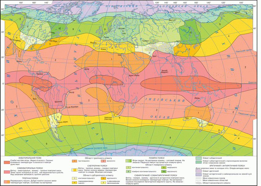
Fig. Climatic zones
Working with map
1. Where on Earth is equatorial climatic zone? What there dominated air masses? As at equatorial climate change in air temperature and rainfall throughout the year?
2. What is the cause of very hot and dry tropical climate zone?
3. Between that climate belts is subtropical zone? How it affects dominance in it air masses during the year?
4. What climate region allocated within the temperate zone? As a result of factors which moderate climate zone has the following types?
5. Where common and arctic Antarctic climate zones? What is the climate there is formed?
6. Within which climate zones of Africa and Antarctica located?
7. Which climate zone occupies the largest area in Australia and South America?
8. On which continent pulse reach climatic zones broken? Why?
9. Which climate zone and climate region is Ukraine?
 Questions and Tasks
1. What are the main factors shaping the climate community?
2. What is the main climatic zones differ from the transition?
3. Describe equatorial climate. Why big falls on the equator rainfall throughout the year?
4. Why in the tropical climatic belt extended desert?
5. What are the air masses dominate in the subarctic zone in winter, and what - summer.
6. What information gives the map of climatic zones?
 English