§ 23. Major river basins
1. Remember that name and river system river basin.
2. What do you know the river that runs through Ukraine?
The vast majority of rivers in Ukraine (94%) is to the Black and Azov Seas. Only the river west of the country related to the Baltic Sea basin. Some small rivers in the south countries do not have a sink in the oceans. This distribution of river runoff caused by the total surface structure of Ukraine.
 Amazing Ukraine
European watershed
In Ukraine, the main European watershed. He divides the basins of rivers that flow down into the northern (Baltic and North) and Southern (Mediterranean, Black and Azov) Sea. The line passes through the watershed Lviv, in which the starting seven small rivers: water three of these flows in the Western Bug, which tends to Baltic Sea, and four - in the Dniester, which flows into the Black Sea. So drops of rain that fell on the roof ridge building in Lviv may subsequently appear in different seas, remote from each other more than a thousand kilometers.
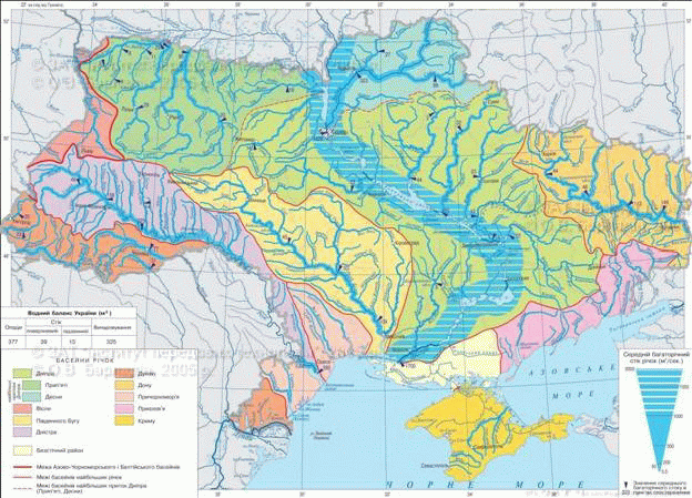
Fig. Surface water
Work with map
1. River Basin which covers the largest area in Ukraine?
2. Where most of the major rivers flow into Ukraine?
3. What can be called a river border? On the verge of countries which they occur?
4. Name the largest right tributary of the Dnieper.
Rivers of the Black Sea. At all times, everywhere River played an important role in the life and activity. Sometimes they are so strongly included in everyday life, economic Activities and culture nations, which became their national symbol. It is similarly impossible to imagine without Ukraine Dnieper-Slavutich. It is for us not only the powerful waterway, beautiful decoration, but also display the soul of our nation, its history. On the banks of the Dnieper formed the core of Ukrainian state - Golden Kyiv, was born first Ukrainian democracy - Zaporozhye Cossacks, with its steep looks native expanses of national genius Taras Shevchenko.
Dnipro floats mid Ukraine from north to south. It collects water with almost half of the country, getting them from northern, western and eastern territories. The river originates from a small swamp on the Valdai Hills in Russia at an altitude of 220 m above sea level. Then flows through the territory of Belarus and in Ukraine as part of a large flowing river with a wide valley. It has a meandering channel with point bar, sleeves and islands. The depth of the Dnipro is 3 - 12 m, width - 700 - 1500 m. In its many lakes, floodplains bayou, wetlands. The right bank of the river high and mountainous, while the left - low and flat. Where the Sky Crossing Ukrainian crystalline shield (between Dnipropetrovsk and Zaporizhia), were once thresholds, which are fully perehorodzhuvaly river. Now all of them flooded by the Dnieper Reservoir. A number of reservoirs built on the Dnieper, not only flooded thresholds, but also very changed its shores, spryamyla track. Among the many water Islands (Greyhound within the city of Osh, Truhanov within the city Kyiv). A few outfalls Sky falls in Dnipro estuaryAnd since it one wide mouth - in the Black Sea.
Sky has more than 1150 small, medium and major tributaries. The largest of them Pripyat (Right) and Desna (Left) generate nearly half of annual river flow. Among the tributaries of the Pripyat longest is Stir і Gorin with SluchAnd among Desna tributaries - Diet. Greater rights tributaries are also Adder, Ros, Ingulets, Left - Sula, Psel, Vorskla, Orel, Samara. Power is the main river and its tributaries mixed. Spring snow melt causes flood in summer and winter mean water is observed, sometimes occur in autumn flooding. Freezing lasts from December to March. Sky has a large annual runoff (53,5 km3) As an important source of water for population and the various branches of industry. Dnieper water watereth "hundreds of cities and villages located on its banks and channels allocated to Donbass industrial needs and Kryvbas, Irrigation of dry Black Sea steppes and Crimea. Dnipro - is important traffic arteries. River navigable throughout the length. The importance of the Dnieper and as a source energy. Its water turns a turbine several hydropower stations that produce the cheapest electricity. But because of the construction of reservoirs were flooded large areas of fertile land, moved to new places a lot villages, destroyed many cultural and historical monuments. Is growing Dnipro water pollution. Especially dangerous is the contamination, caught in bottom sediments as a result of the Chernobyl accident in 1986 So Sky requires appropriate protection.
Records Ukraine
Longest river of Ukraine is the Dnipro: its total length from source to the mouth is 2 201 km, and in Ukraine - 981 km. This is the third longest river and basin area of Europe (after Volga and Danube).
Title says
The ancient Greeks called Sky Borisfen (wide seat), The Romans - Danapris, and Slavs - Slavuta. Title Dnipro associated with the oldest recorded variations: Latin Danapris, East Slavic Danapr, Ukrainian Dniper, Russian Dnepr, Belarusian Notes Your name. Regarding its origin are several versions: of Thracian This – water and Ypres – one that spreads, deep water. Parallel title Slavuta, Slavutych probably formed from pre-Slavic words: Slow – flow or glory – clean, transparentOr sluti – coined, or words – famous.
Amazing Ukraine
Rapids
To accurately determine what the thresholds will tell you what Ruthenian this word means rocky stone. Thresholds - as if a chain of rocks outspread across river. Some of the stones under water, others - at the level of surface water, others were at 10 feet above the water and they are great as houses very close together near one, so it looks like a dam that assures a flow of the river, which then fell in some places the height of 6 - 7 feet, depending on what level of water Borisfen.
Guillaume de Boplan, 1651
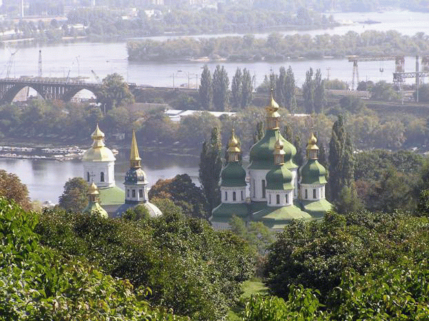
Fig. Dnipro River in Kyiv within
Second longest river and basin area in Ukraine is Southern Bug. It is the only major rivers that fully collects its water from the territory of Ukraine. The largest tributaries are Cyanosisand Ingul. Pool River mostly within the Ukrainian shield, so it and its tributaries Tubular. In some sections there are canyons of granite banks. Southern Bug River flows into the estuary, which is an offshoot of the Dnieper estuary. Only navigable rivers in the lower reaches. On the river built several small hydroelectric power stations on its banks are three regional centers.
Title says
Southern Bug first mentioned in Herodotus VArt. BC. BC called Hipanis – Horse (On its banks while known for some herds of wild horses), the Turks called it Axioms – White water. In the local pronunciation of the name sounds God, Rarely Run, that probably pre-Slavic language to mean flow, surety.
Records Ukraine
The longest river that flows entirely in Ukraine - Southern Bug is 806 km long.
Dniester has a length of 1362 km, in Ukraine - 705 km. His diversion is located on the slopes of the Carpathians. On top of a typical mountain stream in middle stream it into a flowing river with a wide valley. Between Podolsk and Carpathian heights of the Dniester valley narrows and acquires canyon form. His runway extremely winding. Dniester falls in a wide Dniester LimanThat narrow mouth is connected to the Black Sea. The largest tributaries - Stry Limnytsya, Seret, Zbruch canyon, Murafa. River and its tributaries have a mixed type of power. Flooding occurs in spring, summer and autumn there are floods. Water used for the Dniester water supply and enterprises, irrigated fields. On the river built HPS. In the middle and lower reaches of the Dniester is navigable, but now the river almost not used as a transport path. On the banks of the Dniester are Such famous historical and cultural centers, as Galich, Khotin, Odesa.

Title says
Dniester first mentioned by Herodotus in name Tiris, Later called Scythians his Tiras, Moldovans and Romanians - Nistru, Ukrainian - Dniester. Perhaps these names mean fast water.
On the border between Ukraine and Romania for its lower flow (Length 175 km) runs second longest river in Europe - Danube (Total Length - 2960 km). He is one of the most affluent rivers of Europe. Pours into the sea several outfalls. One of them - Chilia - Runs along the border of Ukraine and Romania. Him is the biggest drain passes. Kyliandelta actively put forward in the Black Sea to a distance of 180 meters per year. Delta cut numerous straits and covered with lakes, overgrown with reeds. It - Danube flowing - a unique place wintering and resting during the flight many birds. Danube has a mixed type of power, which is dominated by rain water. The river freezes only in very cold winters. Major tributaries of the Danube that originated in the Ukraine are Tisa, Prut with Cheremoshem і Siret. They begin in the Carpathians, where they have rapid flow, lots of rapids and waterfalls. They have a lot of water and silt stones, which subsequently deposited on the plains. Danube - is important traffic backbone of Europe.
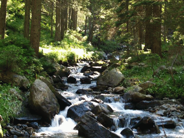
Fig. Rod near the source on the slopes Goverly
Title says
BC lower Danube Greeks called IsterTop - DanuviyAnd Celts - Dunavius, Hungarians - DunaRomanians Dunaprea, Bulgarians - Dunave, which means dropping a large water.
Records Ukraine
Naypovnovodnishoyu Ukraine is the Danube River, the annual runoff is about 123 km3, Which is twice more than in Dnieper.
Amazing Ukraine
International river
The Danube flows through Germany, Austria, Slovakia, Hungary, Serbia, Croatia, Bulgaria, Romania and Ukraine. He Channel connected to the Rhine, which is navigable in Germany, Switzerland, France and the Netherlands. This water transport network of Ukraine can be reached the largest port of the world - Rotterdam, located at the mouth of the Rhine.
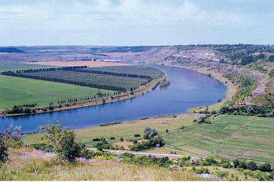
Fig. Dniester River valley near the village. Nahoriany, Mogilev-Podolsky district, Vinnitsa region.
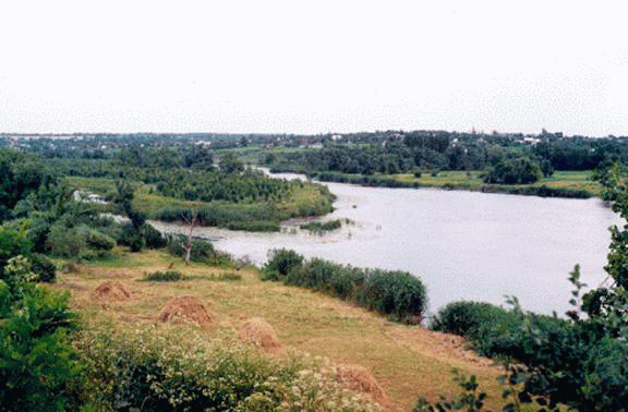
Fig. On the Southern Bug River near the village. Lupolove Ulyanovsk district of Kirovograd region. zimknulys borders three areas
River basin of the Azov Sea. The largest river in eastern Ukraine - Seversky DonetsWhich is a tributary of the Don. Upper and lower reaches River in Russia, in Ukraine length - more than 670 km. It flows in Wake bumpy, has a wide valley. When driving in Donetsk range narrow valley, there are rocky slopes. The highest water level in the river happens in the spring and summer she strongly milli. The largest tributaries - Oskol, Aidar, Luhan. On the river many cities and industrial enterprises which pollute it and mine waste waters.
To medium length river basin of Azov sea are Kalmius Byrd, milk, Salgir. They proceed in Drylands and so shallow, and in the downstream Salgyr dry.
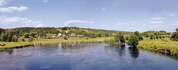
Fig. Seversky Donets River
River basin of the Baltic Sea and internal flow. In the Baltic Sea have their water Western Bug and XiangWhich are tributaries Vistula. Western Bug River and its tributaries start flowing and the flat, while the top of Carpathian San is mountainous.
In the inner basin are some of the river flow in Odessa. In particular Great, Average and Small Kuyal'nyk. They fall in and Hadzhybeyskyy Kuialnyk estuaries have lost touch with the Black Sea. Rivers in the summer dry up.
Remember
Most of the rivers of Ukraine belong to the pool Black and Azov seas, much less - the Baltic Sea basin and internal flow.
The area Ukraine occurring the second and third longest river in Europe - the Danube and Dnieper.
The biggest and longest river basin area Ukraine is the Dnieper.
To the largest rivers of Ukraine are also Southern Bug, Dniester, Seversky Donets.
 Questions and Tasks
1. Spread the Dnieper river system. Which cities of Ukraine Dnipro given name?
2. As terrain features affected the nature of the flow and structure of the river valley Dniester?
3. What are the rivers of Ukraine belong to the Azov Sea basin? What features of their supply and hydrological regime?
4. What do the river in the lives and economic activity.
5. What rivers flow in your area? Try to give them a hydrographic characteristic.
6 *. People always revered river. They glorified and depicted in various art writings. Using literary and other sources, choose verses, passages of prose and pictures illustrate rivers.
Practical work 4
SUBSCRIBE contour map of main rivers and their tributaries, the names are listed in paragraph.
 English