The area of the city (as increased Kyiv)
Key question
- How changed the town?
- What factors have caused these changes?
- When and why was the left bank part of Kyiv?
In the case of only one area city, we saw how it changed over the centuries. What we say about an entire city?
What occurs in our minds when word "Kyiv"? Huge city, which lies on both banks of the Dnieper. But was not always.
Remember: "? And they set Hail in the name of his older brother? ". So hail the city - it is only by strengthening Mount. So there was a first historical part of town - Old Kyiv, Upper City. Later there was the other part - Division. Podollya, Podoliya as his called the ancient chronicles. After some time around the Cave Monastery began to form his third part - Pechersk.
Source 1
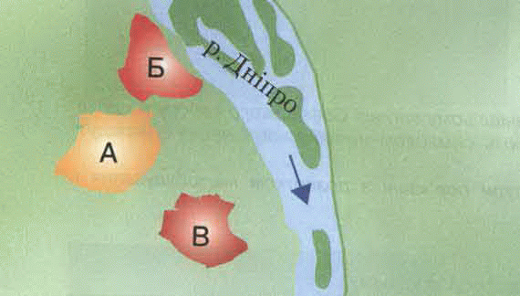
Scheme of ancient Kyiv (per G. Logvin)
Task:
- Find the diagram of the three named ancient city.
- Think and tell me why they came here formed.
These three parts of the city rather were weakly related to each other and exist as though separately. Upper City was an administrative center: it housed the residence of the prince and focused management. Lower City – Division - Was craft-shopping center. And Rooks and the village around him then were far enough outside the city.
Mongol invasion almost completely destroyed the Upper City. It more or less rebuilt only XVII.
From 14 cent. city within Lithuania, and from 1569 - Lithuanian-Polish state, the center of the province. But magistrates castle was built on Castle Hill (actually, it from him and named, called her to Shchekavytsya), life in the old city revived very slowly.
Source 2
(A) Martin Hruneveh (Lviv merchant). From Notes "(the description Kyiv. ) 1584
"Kyiv is situated in a deep valley between high mountains. He stretches on three sides, one side of the triangle is the Dnieper. Two other vpyrayutsya parties to the mountains? "
(B) From the Blog Erich Liasota (Austrian diplomat) end of the XVI century.
"For a quarter mile from the town down the Dnieper River in the hill stands Monastery of the Caves, where a Ruthenian Metropolitan with his post. "
(C) From the results John Lukyanov (Russian officer) second half XVII.
"? In the upper town and governor lives colonels and shooting shelves and in the lower city all commoners;? them here in town hall and all ranks, Several trades? "
Let us consider:
- As described by the territory of Kyiv source 2 (a)? Which part of the city (see source 1) meets this description?
- To determine the location Caves source 2 (b)?
- How can I determine from source 2 conditions of different parts of Kyiv, their relationship?
- Draw conclusions.
Since the second half XVII. Kyiv became a member of the Russian state and became a border city. Therefore, in the XVIII - early XIX century. built a fortress at the Cave. It was not even a fortress and a number of defensive and auxiliary facilities. Fortress and all overgrew overgrew. Since its emergence changed the traditional relationship of parts of the city. Center Kyiv Pechersk was - here moved the military and government agencies, there was a royal residence governor. In the middle of the XVIII century. and built a royal palace - to the king had a place to stay when visiting Kyiv. Now it is famous Mariinsky Palace.
Help
- Master Plan - that the general plan development of the city as a whole. Provides usually right - regular - House entire neighborhoods, streets, districts.
In 1837 has its first City master plan prepared by the famous architect Victor Beretta (He built the house of the University). According to the plan of three parts united, and the center where they would like converged, became Khreshchatyk. Pechersk and Upper Town ", gathered on Independence Square today, and Kiev and Division - a modern European area. Plan includes regular construction - construction of new streets for a particular plan. These streets, unlike the old are formed by themselves, were the direct and crossed at right angles. In Hreschatika main boulevard of them were (now Shevchenko), United Antonovich, Alabama. At the tail after the fire of 1811, which almost completely destroyed the old building, also decided to lay new and build up their street with the plan (see source 4 (b))
Source 3
(A) A memoir M. Ge (Known Russian artist, he studied in Kiev
30's Nineteenth century.)
"? Kyiv was not the same as now, – it was mainly at the Cave? then at the hem and at Old Kiev, which ended near the Golden Gate, where a shaft? Other - were vacant and the chasm that had different names. One of wastelands built university, and this place was called "new building".
(B) From the story AM Leskov"Caves of Antiquity" (M. Leskov - the famous Russian writer, lived in Kiev 30-40-ies Nineteenth century.; Antique - antiquities here)
"I knew this lovely city in its doreformenomu as with many wooden houses on the corners where then? already been posted so-called bibikovski board. In each such board was severe inscription: "in crack of a certain year? "
These unfortunates doomed to break houses were extremely much? "Bibikovski board" fallen upon me unexpected sadness? ... Look - spruce little windows on them with red pepper pots? yards in depth ? Cackler chickens, and suddenly something and something will come here for some strangers Break it and everything? What is it? Where podinutsya these people who probably life is good for their white curtains? Maybe? All this was necessary, but gave some unpleasant and rude brusquerie samovlastyam. ? Old Town Pechersk and especially lavishly decorated with "bibikovskymy boards, because here should have been completed and? completed planned capital Bibikov transformation.
Kyiv then differed greatly from today? Appearance changed for the better, that city was filled with beautiful buildings and, so to speak, yevropeyizuvalo, but I personally regret a lot of old? I am sorry, for example, lifeless Cave and surrounding tracts that were built up as horrible, but very picturesque.
(C) D. BibikovLeaving Kyiv in 1852
"Popularity, I did not want love from you do not have but for me, respect, the later generations will remember my service in the province.
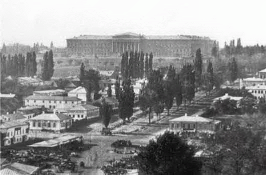
"New building" in the middle XIXArt.
View from the modern district of Bessarabia Square
Help.
D. Bibikov - Governor-General, the Kyiv in 1837-1852 His name was named the new boulevard, which prorizav city and became its embellishment. Now it Taras Shevchenko Blvd. Existed at Kiev University Bibikov established scholarship. Daughter Bibikov transferred to university father's library book collection - 14 thousand volumes.
Us consider
Compare source 3 (a) and 3 (b). How has the city?
What kind of reforms described in Source 3 (b)?
Why were "bibikovski board? What is the attitude to AM Leskov this?
Why he calls Pechersk "deprived of life"?
- Do you agree with Leskov violent attitude to the development of the city? Explain what and why.
- How do you think it fulfilled Predictions D. Bibikov (source 3 (c), (g). Explain your point of view.
At the end of XIX century. begins rapid industrial development of Kyiv, and with this increase sharply the size of its population. On the outskirts of the city - suburbs like mushrooms after rains, new plants and factories, workers' settlements around them. Shortly they merge with the city.
Glossary
Census - Organized Power calculation of the total population to have accurate information about its quantity, national structure, property situation. The first census conducted even in the ancient world - to determine the number of taxpayers.
Source 4
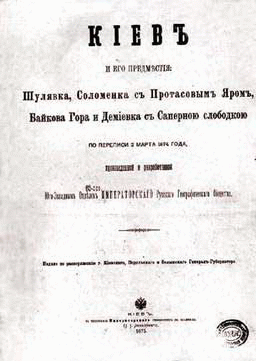
(A) Census 1874
(During the census 1874 there were only 4 suburb)
.
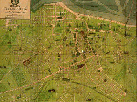
(B) Site plan of Kyiv 1905
Let us consider:
- How do you understand what a "suburb"? Which ones are listed in source 4 (a)?
- Find it on the plan (source 4 (b)). Which ones remaining suburbs and what we can not say so?
- Define areas of regular building and justify their opinion. Why do they coincide with the former suburbs?
- What can you conclude from comparing sources 4 (a) and 4 (b)?
Source 5
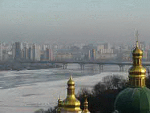
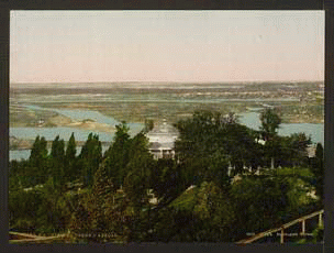
(A) View on the left bank of the Dnieper with Cave Hills 1890 and now
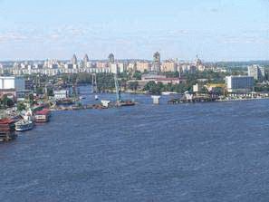
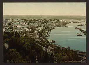
(B) View of Vladimir Hills Division 1890 and now
Consider rozdyvlyayuchys and comparing:
- What are the differences you notice?
- How you can explain?
Growth continued in the city Twentieth century. Especially after the Second World War, when the housing problem was one of the main problems of the city. To help new technologies come construction. Buildings collected from finished blocks - roughly the same as in constructor. We built not individual homes and neighborhoods at once - with children gardens, schools, houses of life, shops. So there were residential arrays - Chokolovskiy, cuddly, Nikolskaya Borschagivka. City strongly went on the Left Bank. And using the so-called hydraulic gave opportunity to build up former lowlands, which earlier were always floodplains or torrential bows. So there Rusanivka Berezniaky and later Kharkov array and Poznyak, Obolon on the right bank.
Help:
Hydraulic – by filling special mechanisms or low-lying wetlands with sand, which is exhausted from the river - as in the alluvium of water: hydraulic ago.
Let us consider:
- How do you understand what was "housing problem"?
- What made it possible to build up the left bank and lowlands right?
- Do you think that positive and negative in hydraulic?
Working with map
Source 6
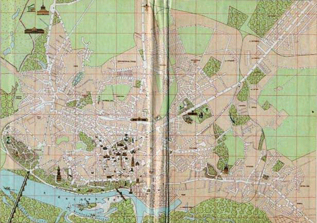
(A) Map-scheme of Kyiv 1959
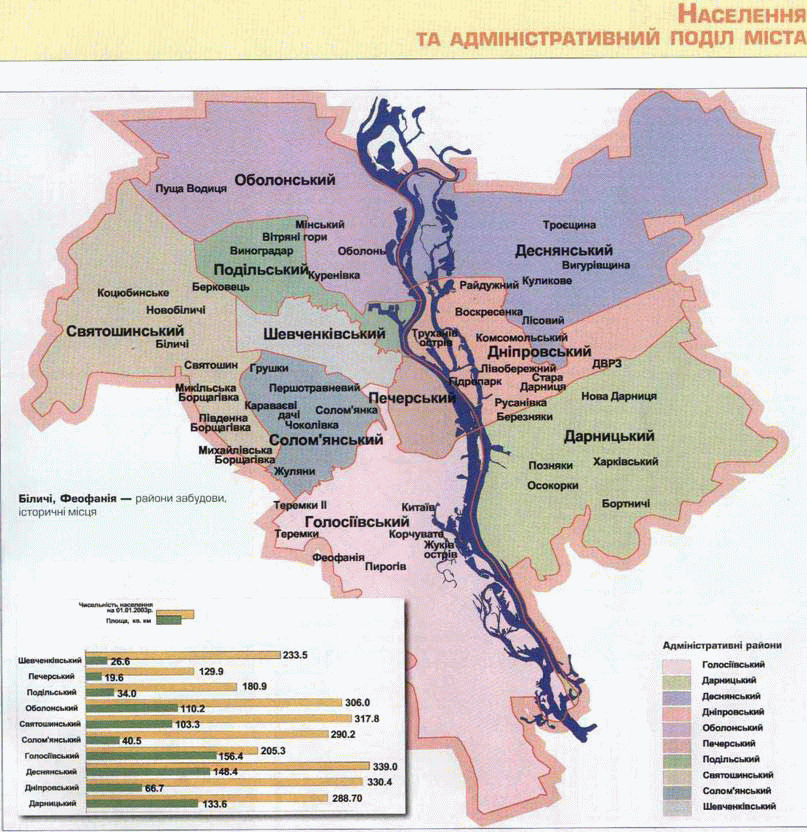
(B) Current maps, charts, reflecting divide the city into districts,
its area and population
Consider calculate:
- that dramatic changes have occurred with territory of the city?
- Locate areas with the largest and smallest area and number population. Take a guess why this is?
- Look for areas that correspond to the three oldest historical part of town.
- Find the youngest districts
- Sometimes Svyatoshinsky, Desnianskyi, Kiev and some other areas are called "sleeping". As you think, why?
- In which district you live? Find it on the chart. It belongs to the historical part of town or to emerging? What do you know the history of your neighborhood?
Invite parents
- Walk into one of the interesting places for your area (parks, Leisure, interesting buildings, monuments). Make a story about it. Take a message to friends. Together, make a map of "raisins" of your district. Information about such places, history and modernity area you can provide in Regional State Administration.
 English