§ 10. Indian Ocean
1. Remember seafarers who first Europeans crossed the Indian Ocean.
2. What is Indian climatic zones Ocean?
3. What winds called monsoons?
Surface Ocean - 76.2 million км2.
Average depth - 3700 m.
Maximum depth - 7729 m.
GEOGRAPHICAL LOCATION AND SIZE. Indian Ocean by narekly name great, fabulously rich country India, which he washes the shores. And India itself received its name from the river IndusThat runs "the country indiv. The name Ocean for the first time appeared on a Portuguese map of 1490 referred to this ocean Great Gulf Eritrean sea Indian Red Sea, the South Sea.
Indian Ocean located between Africa, Asia, Australia and Antarctica. Unlike the Pacific and Atlantic, it is mainly in the Southern Hemisphere. Indian Ocean joins the Pacific extensively and Atlantic. But he has no connection with the Arctic Ocean - access to He replaces Eurasia. Indian Ocean is the third largest ocean of the Earth.
In northern coastline ocean divided Bengaliand Persian bays, Arabian and Red Seas, deeply cut into in the dry. Islands relatively little. The biggest of them - Madagascarand Sri Lanka - Have mainland origin. There are also volcanic and coral islands.
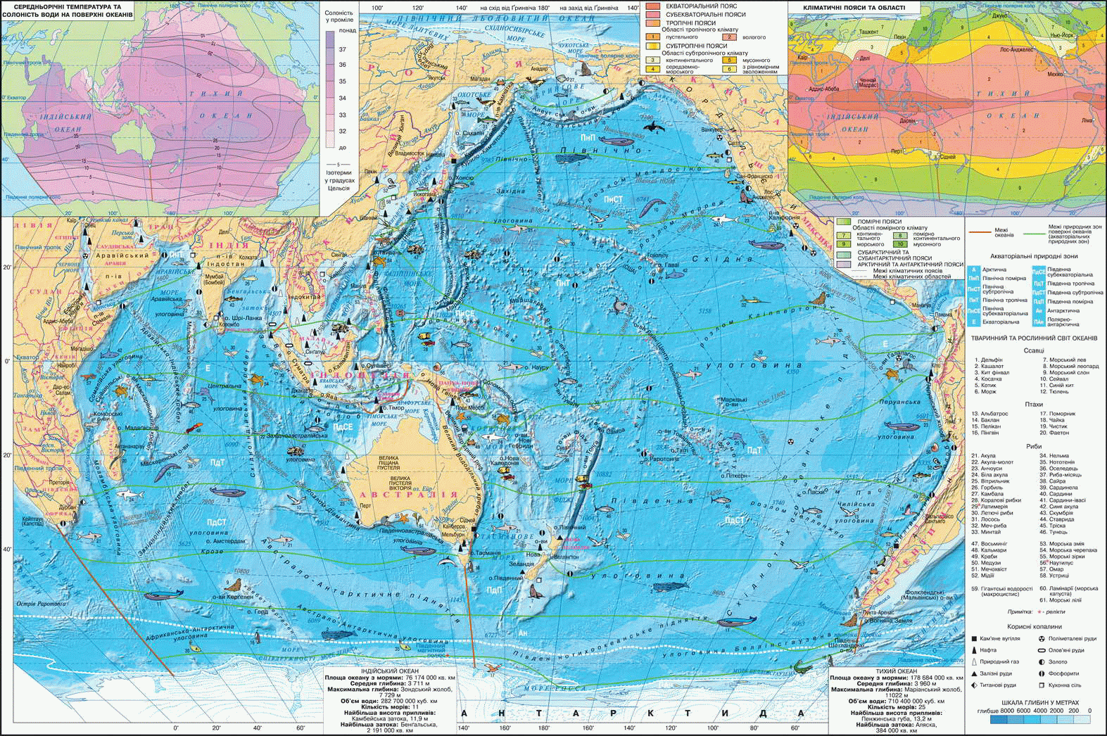
Fig. Indian and Pacific Oceanи
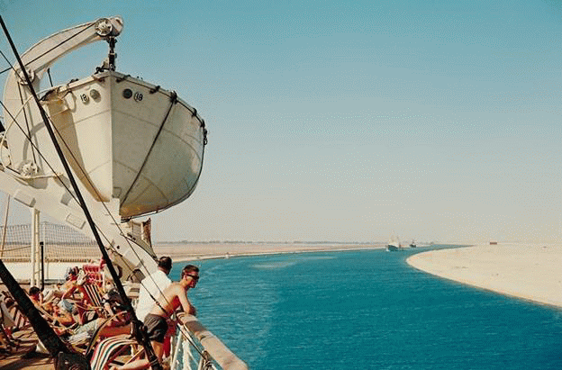
Fig. Suez Canal connects the Atlantic basin and Indian Ocean
Working with map
1. Identify major geographical features provisions of the ocean.
2. Indian Ocean - an area of ancient civilizations. Name the ancient countries of the world, established on its shores.
3. How are the Mid-oceanic ridges? What hollow cavity they share the ocean?
4. What feature of the Indian Ocean has a shelf? What and the Gulf Islands are on the shelf? Which of the Indian Ocean Sea more its part located on the shelf?
5. What are the emerging trends in winter in northern Ocean? How does their movement in the summer?
HISTORY STUDY. There is information that Indian Ocean people began to develop more than 3 thousand years BC. e. His Egyptian waters, Phoenician, Indian merchants and sailors brought spices, ivory, tissue. In the fifteenth century. Chinese navigator Wives Ho sailed to the Indian Ocean coast of India and beyond - to Africa. In 1498 Portuguese Vasco da Gamabecame the first Europeans who crossed the Indian Ocean and reached the shores India. In the eighteenth century. English navigator James Cook made first sounding the depths of the ocean.
Comprehensive study of the same Indian Ocean marine began in the nineteenth century. English, German and Russian expeditions to research vessels studied seabed structure, properties of water and organic world Ocean. Today scientists around the world continue to explore the ocean for using underwater vehicles and satellites.
Structure and shape of bottom. Indian Ocean lies within three lithospheric plates - Africa, Indo-Australian and Antarctic. At the edge of the plates have Mid-ocean ridges. They have three branches - Arabian-Indian, Zahidnoindiyskyy, Tsentralnoindiyskyy spine -Scattered from center. For ridges characteristic faults, because in these areas often there are earthquakes and volcanic eruptions. Faults continue the Red Sea and then on land. Between submarine ridges on the bottom are basin. It is a hilly plain. Unlike the Pacific Ocean, Indian little deep trenches. Maximum depth is made in Sunda Trench (7729 m), located in the eastern part of the ocean.
Continental margin, framing Indian Ocean, a narrow stretch (100 km) strip of the shelf break and down steep continental slope.
 Interesting geography
Geological Weather
Scientists believe that due to movement lithospheric plates in about 50 million years to grow in the Indian Ocean sizes. Instead, Pacific ocean reduced. Africa will shift further to the north, cross the equator and Australia with’united with Eurasia. However, this only forecast that requires clarification.
CLIMATE AND WATER MASS. The geographical position is determining factor in shaping the Indian Ocean climate. The northern part lies in the equatorial ocean, and tropical latitudes subekvatorialnyh, ie a hot thermal zone. So there is good water warm and the sea and the Gulf warmest in the Pacific Ocean. The highest water temperature observed in Red Sea and Gulf - 35 0С.
This part of the ocean is strongly influenced by land. Therefore, the climate there is formed monsoon - winds that change direction with season. Warm and dry summer over set low pressure, and over relatively warm ocean - high. Then southwestern monsoon blows from the wet ocean. In winter, on the contrary, above the cold there is a relatively dry area of high atmospheric pressure than on Ocean. As a result formed the dry northeast monsoon, which blows from mainland. Therefore, in the northern part of the ocean two seasons - hot, cloudy, rainy, stormy summers and warm, quiet, dry, sunny winters. In the western part arise Ocean tropical cyclones (hurricanes). Moving north to southern shores of Asia, they cause great damage.
South Indian Ocean is quite cold cooling effect due to Antarctica. Near its shores temperature surface water is –1,5 0S. Limit of floating ice extends to 600 AP. Rd., harbor icebergs. In temperate latitudes during the year strong west winds prevail, causing frequent storms.
From the ratio of rainfall and evaporation depends on the salinity of surface ocean waters. In equatorial zone, where most precipitation falls (up to 3 000 mm per year), oprisnyuyut water salinity is 34 ‰ .. In the tropical rainfall zone little, and evaporation is great, because there saline water - 37 ‰. The highest salinity the world is the Red Sea - 42 ‰. Off the coast of Antarctica salinity decreases water through desalination talymy ice cover.
FLOW. In the northern part of the ocean flow is closely related to monsoons. In winter, under northeast monsoon occurs powerful heat Monsoon flowThat takes surface ocean from east to west. Summer due to southwest monsoon is getting weaker, while Somali currentdramatically amplifies and surface water moving in the opposite direction - from west to east. Thus reconstruct monsoon system of surface currents in Ocean seasons: summer water movement is clockwise, and in winter - clockwise.
In the southern Indian Ocean formed whirling motion of surface water counterclockwise, as in the Pacific and Atlantic Ocean in these latitudes.
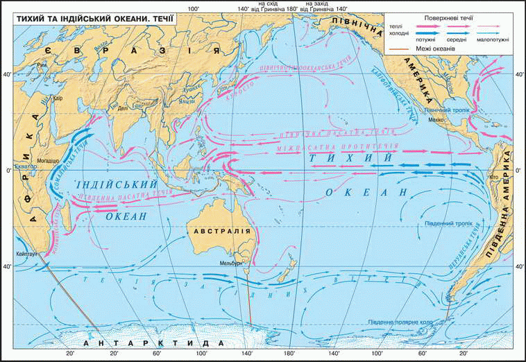
Fig. Indian and Pacific Oceanand. Flow
ORGANIC WORLD. Water Indian ocean is the habitat of various plants and animals. Brown, Green and red algae bordering coasts of continents and islands, forming underwater meadows. Among the hundreds of species of fish common sardynela, mackerel, horse mackerel, nototeniya, grouper, tuna, dorado. Living in the open ocean sharks and different kinds of volatile fish.
Especially rich life rages in coastal areas and shallow water near coral reefs. They live cuttlefish and squid, spiny lobsters and shrimp, starfish and sea urchins. Sea snakes, which feed fish is very poisonous (their venom is 12 times smertonosnisha by cobra venom). There giant turtles and dolphins. In temperate and polar latitudes near Antarctica many whales and seals.
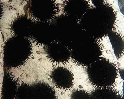
Fig. Sea urchins
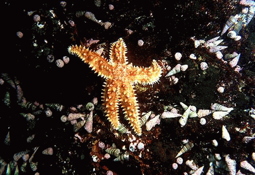
Fig. Starfish
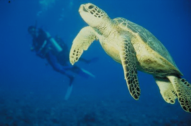
Fig. In the warm waters Mozambican Bay
Natural resources. Unlike other oceans, biological resources Indian Ocean little studied and utilized. In particular, fishing for Experts estimate can be increased several times.
For stocks and Oil and Gas Indian Ocean ranked first in the Pacific Ocean. His Persian Gulf became the calling card of the marine oil. On its shelf mastered some of the world's largest oil and gas deposits. Oil and gas tankers exported to various countries. In coastal areas produce pewter ore and phosphates.
Countries that are located on the northwest coast Indian Ocean in a hot tropical zone, suffer from lack of fresh water. Because there have learned to desalinate sea water salinity.
After the Indian Ocean sea routes ran numerous worldwide importance. Handmade Suez Canal connects the Red Sea Indian Ocean from the Mediterranean Sea Atlantic Ocean. He cut way from Europe to Asia by 9000 km. The northern coast of the ocean - great places rest. This is supported by a warm climate, beautiful sandy beaches, picturesque landscapes of the islands, a unique underwater world (Fig. 38).
Impact of human activities on ocean. Indian Ocean - a water area, mined where and how transported huge amounts of oil. Yes, with Gulf oil is littered with towers and platforms 6 hour pass loaded oil tankers. Each year it exported about 1 billion tons of oil. This inevitably leads to contamination by oil products (gasoline, fuel oil) and oil-water ocean. Oil spills occur due to accidents during transportation. Oil is easier to sea water poured on her thin surface film. The film is breathable. This leads to the death sea creatures that are in the area of its distribution.
Water purification from oil pollution by carrying out through special vessels smittyevlovlyuvachiv that collect debris and floating oil from the surface. However, such measures should be more intense and timely.

Questions and Tasks
1. Compare the geography of the Indian Ocean location of the Pacific and Atlantic Oceans. What is the impact on the nature of Indian Ocean makes its geographic location?
2. Explain how climate depend on temperature and salinity Pacific surface waters.
3. Using the map, name the streams which formed a circle of water turnover in Indian Ocean in the Northern and Southern hemispheres. Why in the northern part Indian Ocean monsoon winds occur. How to change under the influence of their surface currents?
4. Tell us about the animal world the Indian Ocean. What are the main industrial fish caught there?
5. What mineral resources are mined on the shelf of the Indian Ocean? As associated with pollution of ocean waters?
6. Using the card "The structure of the Earth's crust, specify:
a) which should reach the Mid-ocean ridges in Indian Ocean;
b) to which they split the hollow cavity Ocean;
c) that the island is the top of the Mid-ocean ridges.
Practical work
1. Sign in contour map names: islands - Madagascar, Sri Lanka; Bays - Bengali, Persian; seas - the Arabian, Red; submarine ridges - Arabian-Indian, Zahidnoindiyskyy, Tsentralnoindiyskyy.
2. Mark the corresponding colors are warm and cold currents and sign their names - Monsoon, Somali.
 English