§ 15. Geomorphologic structure
1. Remember that external forces acting on the Earth's surface.
2. What landforms formed by wind action and surface water?
Patterns of distribution forms relief.Modern relief Ukraine emerged as a result of interaction between internal and external forces acting during Cainozoic era. Origin and patterns of different forms and types of terrain studies branch of physical geography - Geomorphology.
By matching the physical and tectonic maps of Ukraine, You can verify that the general plan of the relief structure of Ukraine - the location, direction reach and height of the lowlands, hills and mountains - are caused by tectonic structure. Most major forms of relief Ukraine (Volyn, Podolsky and Dnieper Upland, Donetsk logs, Dnieper Lowland and Ukrainian Carpathians) extend from northwest to southeast under the direction of bedding tectonic structures. Important role played by the oldest structure - Ukrainian crystalline shield, Who set a major line of other structures.
Most major landforms of Ukraine have direct relationship with tectonic structures: within the sheet and folded structures Hills and mountains are located, and the corresponding tectonic depression lowland.
However, in the western part of Ukraine relationship between relief and tectonic structures inverse: Volyn-Podolskplate, Galicia-Volyn Basin and Carpathiandeflection inconsistent with their corresponding forms of relief - highland and horbohirni strand. This is the so-called neotectonic movements - Lifting the earth's crust that occurred there in the Cenozoic. Then undergone raising almost the entire territory of Ukraine except the coastal strip Black. Most rose Carpathians and Precarpathians, Crimean mountains Donetsk and Podolsky Hills. This resulted in an active "tie-in Earth's surface rivers that formed the deep valleys with steep slopes, and Podolsk Upland South - canyons.
The main types of relief. Impact on the Earth's interior surface and external forces caused the spread of various types of terrain. From internal processes related to tectonic and volcanic types, and external - gravity, vodnoeroziynyy and vodnoakumulyatyvnyy, karst, glacial and vodnolodovykovyy, Aeolian, coastal, anthropogenic.
Tectonic shape relief formed as a result of tectonic movements of the crust. These are mountain ranges and mizhhirni valley Ukrainian Carpathians (Alternating folds rotated up and down) fold-hat Crimean mountains, Slovechansko-Ovruchskyiridge place the handful of (brylovoho raising the crystalline rocks of the Ukrainian Shield), Donets Ridge (upraised fold) Dnieper, Black Sea and Transcarpathian Lowland (Depressions on the ground) et al.
Volcanic landforms is the result of direct Volcanic activity (Volcanic Ridge in the Carpathians, Berehovo horbohir'ya in Transcarpathia mountain Karadag Crimea) or penetration of magma between layers sedimentary rocks (Mountain Ayudah in the Crimea). The specific forms are volcanic mud. Their cones low – 50 c. Several dozen such mud vulkanchykiv is on Kerch Peninsula in the Crimea.

Amazing Ukraine
Mud volcanoes
Most mud volcanoes Kerch Peninsula went out. However there are also continuously or periodically active. Gaza that break away from the depths of 5 - 7 km in rupture of the earth crust, pushed to the surface with thin loamy mass debris that forms a small conical hills or sloping rise. The eruption of such vulkanchykiv sometimes accompanied by explosions and local earthquakes or spontaneous combustion gas.
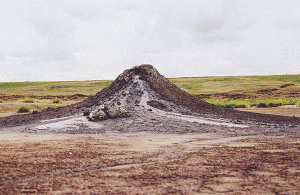
Fig. Mud Volcano in the Kerch Peninsula
Gravity form reliefcaused by processes occurring under the influence of gravity (gravity). To These include collapses and osypyschaWhich promotes active weathering rocks. Large landslides often occur in the mountains. They arise in areas of rocky cliffs, broken by a dense network of cracks on the blocks. By the time to Then these blocks are monolithic. The impetus for the collapse can be a penetration into the cracks rainwater or meltwater that rozm'yakshuye clay layer. Then the giant slabs and flying stones and rolled down, destroying everything in its path. In the mountains and steep right-bank slopes of the valleys of large rivers are often landslides.
Amazing Ukraine
Stone chaos
On rocky mountain troughs South Demerdzhi, That Crimea repeatedly collapses occurred. Foot of the mountain near the village. Radiant hidden chaos of huge stone blocks the size of a three-story house. In 1966, blocks weighing 2 - 3 tons of screens fell from a height of over 100 c. Reverberating hum of powerful collapse was like a loud explosion and the seismic station in Alushta registered it caused tremors like an earthquake.
Water erosion forms relief Related destructive work of permanent water (river) and temporary streams. These forms are river valleys, canyons, gullies, ravines. However, there Water accumulation - the accumulation of sediments, which resulted in having vodnoakumulyatyvni forms: broad floodplain and terracesin river valleys, Delta in mouths Danube and Dnipro.
Records Ukraine
The longest canyon in Ukraine Dniester, whose length is 250 km. The mouth of the Dniester, the Golden Lime Zbruch was to cut into rocks in surface, forming a narrow valley depth of 150 - 180 м.
Karst forms resulting dilution water rocks. Karst caves, funnels, wells, mineextended to Volyn, TailIn Crimean Mountains, Donbass - where close to the surface suitable breed that is easily dissolved and washed with water (chalk, gypsum, limestone, salt). On average in Transnistria junction Podolsk and Khotyn hills is almost fifty major underground voids that have a total length of explored passages over 465 km. Among the three largest gypsum cave in the world: an optimistic (217 km) Lake (121 km) and Cinderella (90 km). Researchers caves - speleologists continually reconnoiter their new mazes and open new cave.
Nature Records
The world's largest cave in gypsum rocks - optimistic, located in Ukraine on Podolski Highland (Ternopil). Its underground labyrinths have length over 165 km.
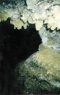
Fig. Optimistic - longest gypsum cave in the world (165 km)
with. Korolevka, Borshchiv district, Ternopil region.
Ice forms relief Related with mountain and Mainland icing. The immediate action of the glacier created former bed of glacial - Penalty(Cavity, similar to the big chair) and Circus (chashopodibni recess). They occur in highest mountain ranges; Ukrainian Carpathians. Vodnolodovykoviform Mainland is the result of ancient glaciation in past geological era. With climate warming after the retreat of glaciers thawed water formed ozy - Long, narrow sand and rubber ing -Sandy Hills. They are distributed in Polisskiy lowland.
Aeolian forms relief – sand Hills and Ridge - Arising from the activities of the wind. They are on Polesie, in Lower DniproThe sea kosah.
Interesting geography
Oleshkovsky Sands
In the lower reaches of the Dnieper on the left Riviera has long occupied large areas of sand. In the past they grow forests (Herodotus called them GileaWhat it means or Polesie Oleshshya). During the XIII - XVIII Art. they were completely destroyed as a result of commercial activity. Then there actively began to develop aeolian landforms - moving hills height to 20 c. In the twentieth Art. for consolidating loose sand planted pine forest. But in hot summer 2007 was Forest hit back - this time from the numerous fires.
Coastal landforms formed on the sea coast due to the destructive and creative work of the waves and surf. The destruction caused shore collapses and mudslides. Coast gradually receding, and formed as a result of accumulation of marine Beaches, sand spit, Shafts.
Anthropogenic (man-)form relief - Is the earth's surface irregularities formed by human activities. Quarries, piles, piles resulting mining, and embankments, dams, shafts - As a result laying of communications, construction of reservoirs and more.
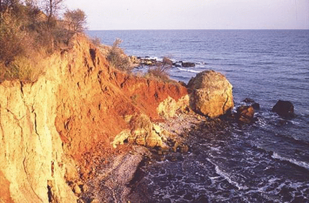
Fig. Landslides on the Black Sea with. Kryzhanivka, Kominternovsky Mr.
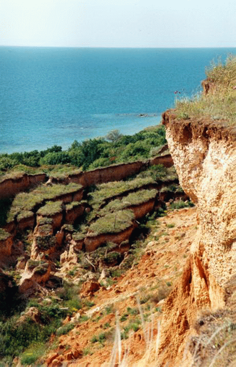
Fig. Landslides in the West Coast of Crimea
Study relief is important for human life. This knowledge is important to search for oil and gas acreage deposits of building materials. Terrain necessary to justify construction of engineering structures, prevent the consequences of natural disasters, a agricultural work, solving environmental problems. Relief, first mountain is a significant factor in the development of tourism, sports and resort and spa management.
<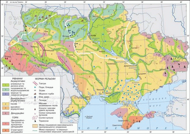
Fig. Geomorphologic structure
Remember
General plan of structure relief of Ukraine due mostly deposits of tectonic structures, communication between relief and tectonic structures may be direct and inverse.
According to the manifestation internal and external relief processes are distinguished different types of relief: tectonic, volcanic, gravitational, vodnoeroziynyy, vodnoakumulyatyvnyy, Karst, glacial, vodnolodovykovyy, Aeolian, coastal, anthropogenic.
 Questions and Tasks
1. Tell us about the relationship of forms of relief and tectonic structures.
2. What are the types of relief, relating to the internal processes?
3. Name the types of relief, resulting of external processes.
4. Where widespread karst landforms?
5. As accumulative landforms formed?
 English