§ 14. Mountains
1. Remember that the tectonic structures in the mountains meet the relief?
2. How to distinguish the mountain height?
Ukrainian Carpathians. Ukrainian Carpathians are part of Eastern Carpathians mountain range. They reach a length of 280 bar km and a width of 100 km from the northwest south-east of Ukraine. In regard to tectonic mountains meet Folded Carpathian building. Carpathians - the mountains are young, mostly medium and nyzkovysotni fold-hat buildings. Significant role in shaping their surface played rivers, deep valleys which were formed along faults. Absolute high mountain ranges from 400 m at the foot of the mountains to 2 000 m along the main ranges. The peaks that rise above 2 000 m above sea level, are array Montenegro. Lack of high mountains, zhladzhenist vertices and flatness of the Ukrainian Carpathians hills because they composed mainly sedimentary rocks, which is easily blurred.
Ukrainian Carpathians are formed by several parallel ridges, separated longitudinal mizhhirnymy hollow and broken transverse breaks into separate arrays. External (Or Chunk) Carpathians - average height, divided into separate tracts: Eastern Beskydy, Gorganand Pokuts'ka-Bukovina Carpathians. Platoes-Verkhovynska Carpathians - Low fold-hat ranges from gently billowing tops and mizhhirnymy basin. There are major Carpathian passes (Uzhotskyy, Volovets, Yablunyts'kyi) Who laid transport routes. Poloninska-Montenegro Carpathians - The highest mountain belt, which include Polonynskyi range, ridges Svydovets and Montenegro, Hrynyava mountains. Their average height is 1 500 m and maximum reach over 2 000 м: Goverla (2 061 м), Brebeneskul, Pip-Ivan Montenegro, Petros, Hutyn-TomnatykRibs(On Montenegro). A distinctive feature of this part of the Carpathians is whether Valleys - Rounded treeless peaks subalpine bows. In the highest mountain ranges extended recess, vyorani glacier.
Maramorosh massif covers Rakhovsky і Chyvchynska mountains. It is steep in places steep slopes, sharp ridges and rocky peaks, deep river valleys. The highest peak - г. Pip-Ivan Maramorosh (1 936 м). Volcanic Carpathians - Low backbone, dissected by river valleys on separate arrays. This is the - strand and the remnants of extinct volcanic cones, of which alternating with flat surfaces lava plateau. Ridge was formed through fault crust on the verge of the Carpathian fold structures and Transcarpathian deflection.

Title says
For certain origin of the name "Carpathian" not installed. The ancient Romans called these mountains Sarmat and Hungarians - Ruska. Some researchers believe that Carpathians means spine, others linked the name of the tribe carp, which, according to ancient geography, living in the Eastern Carpathians, a version that is word means bend, appearance.

Title says
Name Hoverla translated from Romanian mean difficult to pass on raising.
Records Ukraine
The highest Carpathian mountaintops are g. Herlahovsky Shtyt (2 655 m) which is located in Romania and the Ukrainian Carpathians - g Hoverla (2061 м).
Amazing Ukraine
Ukrainian Carpathians - part of the Carpathians
Ukrainian (or Eastern) is part of the Carpathians Carpathians that stretch across five European countries (Slovakia, Poland, Hungary, Ukraine, Romania) in a huge arc length of almost 1 500 km. It starts they Western Carpathians in Slovakia and end Southern Carpathians in Romania.
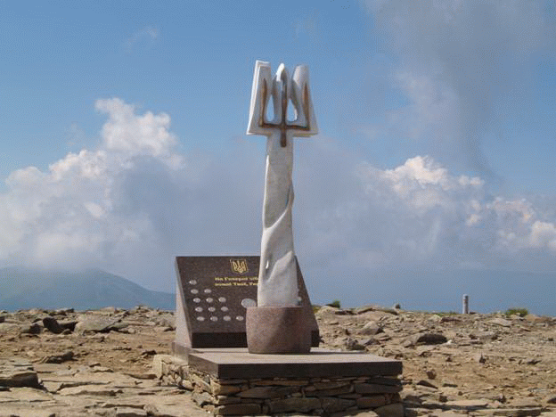
Fig. On top Goverly
Crimean mountains. These fold-hatmountains stretch zone length 180 km and a width of 60 km south of the Crimean Peninsula. They have a lower height and a simpler structure than the Carpathians. In relief distinct three almost parallel ridges separated by narrow longitudinal reduction. Strands have an asymmetrical appearance: their northern slopes and long gentle (Corresponding to the direction of occurrence of layers of rocks), and southern - and steep short (cut out layers of rock). Such asymmetric mountain ridge was called Cuesta.
Outer Ridge the lowest, its maximum height is only 340 м. Internal strand has the height to 740 м. Central ridgehighest, its height reaches a 500 c. It formed the separate files that are aligned stolopodibniflat top - jajlyCovered with meadow vegetation. The highest ranges are: Babuhan-Yayla (With г. Roman-KoshThat has the highest mark height - 1 545 м), Nikitskaya Yayla, Chatyr-Dag Ai-Petry Yayla, Yalta Yayla and Karabi-Yayla. In jajlah widespread karst forms relief - caves, funnels, wells, and mines. The slopes of ridges dissected by deep gorges, canyons, valleys, gullies, ravines. Because of the reduced space of the spine - passes Angarsk та Baydarskie Gate - Laying of roads. In southern The main strand breaks sharply to the Black Sea coastal strip width 12 km - Southern Crimean coast. In place davnovulkanichnoyiactivity appeared massif Karadag, Internal magmatism – Mountain Ayudah.
Title says
Name top Roman-Kosh translated from Turkic literally means forest lair, Ai-Petritranslated from Greek as Mount St. Peter.
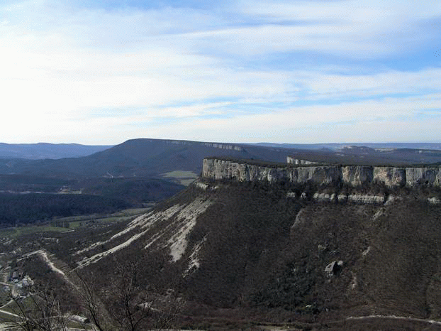
Fig. Outer Ridge Crimean mountains
Remember
Mountains of Ukraine (Ukrainian Carpathians and Crimean) belong to the medium-young age of mountains that formed during Alpine horoutvoryuyuchoyi era.
Ukrainian Carpathians - folded mountain system consisting of three main strands-folds and one volcanic mountain range.
Crimean mountains - fold-brylovasystem formed by three mountain ranges.

Questions and Tasks
1. Why Ukrainian Carpathians have low and medium altitudes, although by age are to young rip?
2. What mountain ranges are in the Ukrainian Carpathians? What is called meadows?
3. As Crimean Mountains stretch? What is called yaylamy?
4. Or Have you been in the mountains? Tell us what you think.
 English