Theme 17. Ukrainian Carpathians
Ukrainian Carpathians - a geographical region, covered mountains of the Carpathians, and their north-east and south-west lowland foothills. Land lies in southwestern Ukraine and wedged in a triangle between the state border of Ukraine and a conditional line Chernivtsi - Ivano-Frankivsk - mapleWhich separates it from the East Plain. The area of the Ukrainian Carpathians within these limits is almost 40 thousand km2. Ukrainian Carpathians are a large part of the Carpathian physical-geographical countries distributed in several European countries.
The land is divided into three parts, which have significant differences in natural conditions: Precarpathians, Carpathian mountainsand Transcarpathia.

Amazing Ukraine
Ukrainian Carpathians - part of the Carpathians
Ukrainian Carpathians are part of the Carpathians, which extend to five countries in Europe a huge arc length 1500 km. Starts are the Western Carpathians in Slovakia and Southern ends Carpathian Mountains in Romania. The highest peaks of the Carpathians is g. Herlahovsky Shtyt (2 655 m). Ukrainian Carpathians - one of the narrowest and lowest areas of the mountain chain - is part of the Eastern Carpathians.
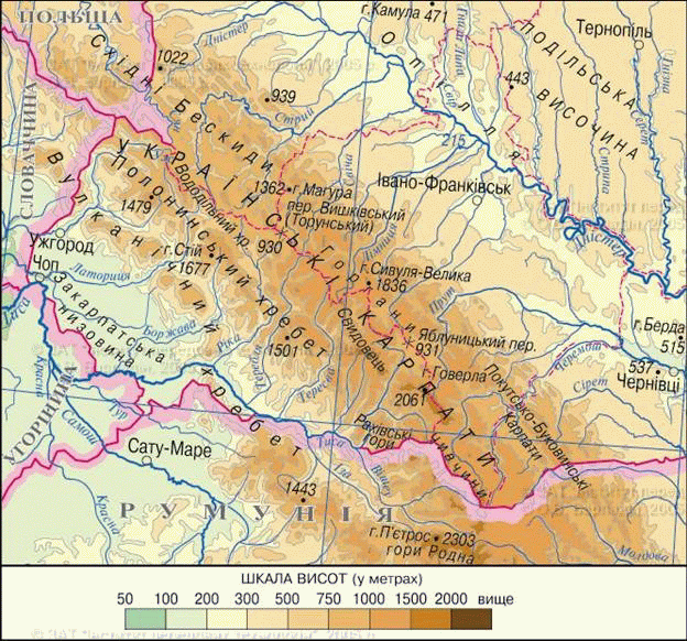
Fig. Ukrainian Carpathians
§ 34. Ukrainian Mountain building Carpathians
1. Remember that tectonic structure is the basis of the Ukrainian Carpathians.
2. Which mountains by age and origin to the Ukrainian Carpathians?
Relief and geological structure. Ukrainian Mountain building Carpathians extends a length of 280 bar km and a width of 100 km. Mountains are the medium of ordinary ridge 1 000 - 1500 m, only a few peaks rise more than 2 000 By the age of they belong to the Young Mountains (formed in Alpine horotvorchu era), but outwardly resemble old mountains with gentle slopes and rounded peaks. It due to the fact that in their geological structure is dominated by sedimentary rocks (Sandstone, clay, shale). Their accumulation occurred in the Sea basin, which existed in the place of mountains, layer with: layers of rocks in turn changed each other sometimes hundreds of times. So there was flyschThat in a crumpled folds formed slopes, and is easy to destruction by external forces.
However wide the Carpathian Mountains with soft outlines sometimes cut deep (more than 1 000 m) transverse valleys with steep slopes. They formed as a result of faults during the latest tectonic processes and deepened rivers.
Mountain building extends from the Ukrainian Carpathians northwest to southeast several parallel strands, unbundled mizhhirnymy elongated valleys. North-east ridge called External CarpathiansTo rise over CarpathianUpland steep escarpment. They cover various mountain ranges. Gorgan(With г. Syvulya, 1 818 m) - The highest central massif, where rocky cliffs frequently. Beskydy and Pokuts'ka-Bukovina Carpathians lower and have destroyed more ridges.
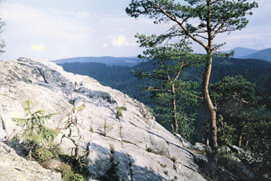
Fig. National parkSkolivskiBeskydy "
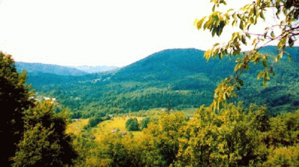
Fig. Sandstone cliff in GorganWith. Mykulychyn, Nadvirna Mr.
Platoes-Verkhovynska Carpathians axis is the average Ukrainian Carpathians. Although they are not the highest mountain in the building (the maximum absolute height reach 1700 m) but are the main Carpathian watershed between the Dniester river basin and River. There are important passages (Uzhotskyy, Yablunyts'kyi, Volovets) Who passes by that linking Precarpathians and Transcarpathia.
Poloninska-Montenegro Carpathians highest. They cover Polonynskyi spineThat cut into separate river valleys, meadows arrays (Equal, Borzhava, Red), mountain arrays Svydovets і Montenegroand Hrynyava mountains. Height of the tallest peaks reach maximum values at MontenegroWhere six of them rise above 2 000 m above sea level. There is the highest point and Ukraine - г. Hoverla (2 061 m). These mountains have preserved traces of ancient mountain glaciation - ice forms relief (circuses and punishment).
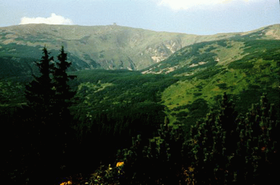
Fig. Spine Montenegro
South of Chornogoryrises Maramorosh massif - The only part Ukrainian Carpathians, where the surface are hard crystalline rocks (gneiss, schist). The array covers Chyvchynska and Rakhovskymountains. It is the oldest (though not too high) part of the Carpathians, which stores features inherent in young and high mountains of Alpine folding. There gabled extended pikopodibni peaks, steep and rocky slopes, river valleys are very deep, clear glacial landforms. No wonder Rakhovsky Mountains have long called gutsulskimi Alps.
From the towering Transcarpathia Volcanic (Vyhorlat-Hutyn) spine. He rises over the lowlands of individual cones extinct volcanoes, lava flows combined in arrays, which ran between steep valley Transcarpathian rivers.
Title says
Name Hoverla in translated from the Hungarian means snowy mountain.
Records Ukraine
Ukraine's highest peak KRIM Goverly (2061 m) is tops in the array Montenegro high over 2 000 м – Brebenskul (2 035 m) Pop Ivan Montenegro (2 022 m) Petros (2020 м), Hutyn-Tomnatyk (2 016 m) and Ribs (2 010 m).
Climate. Climate Ukrainian Carpathian Mountains is determined by geographical location and height above sea level. In the mountains it is cooler and humid than the surrounding area.
With a show for every 100 m late summer for 10 days and 5 days before ending. Heavy cold air can often stagnate in mizhhirnyh decrease as temperature is much lower there than in surrounding mountains. In the Ukrainian Carpathians the largest amount of precipitation falls in Ukraine. If it is in the foothills less than 800 mm per year, the highest in arrays - 1500 mm. Highest rainfall in summer least - in the spring and winter. Often storms, blizzard, spring down avalanches. Under the influence of fluid water formed village – Mud-stone flows arising in the course of mountain rivers. They appear suddenly due to heavy rains or melting snow and fast-moving, acquiring catastrophic nature, causing destruction.
Surface water. In the Carpathians, formed the most dense Rivers Network in Ukraine. Chief Carpathian watershed dividing the basins of different directions. To the north and northeast tributaries flowing Dniester - Stry, candle, Tismenitsya Bystrica Limnytsya and tributaries of the Danube - Seret and Rod of Cheremoshem, and to the south and southwest - tributary of the Danube TisaIn which flow Teresva, Tereblya, Rick and others. Carpathian River Valley lay mostly in longitudinal mizhhirnyh hollows and ridges transverse faults. All rivers have a rapid current. Frequently formed waterfalls - the glory of local landscapes. In spring and early summer due to melting snow in the mountains and large rivers drain to the flood and are flooding. They often leave their banks and cause significant damage to populated towns, roads, economic facilities. Carpathian rivers carry large number of loose material, which lay in its lower reaches. On the slopes mountains in the valleys of landslides occur.
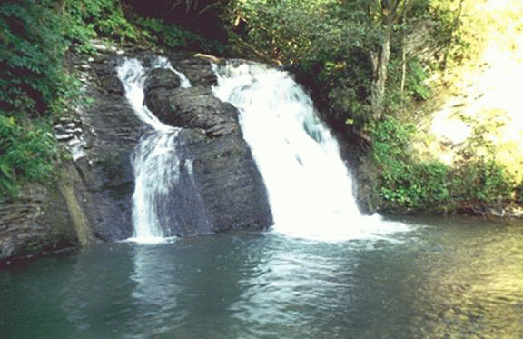
Fig. Waterfall Gurkalo with. Korchyn, Skole Mr.
In the Carpathians, many lakes. They are usually small by area, but very picturesque. The biggest of these is Lake SynevyrThat appeared in the top р. Tereblya due to the dam in the mountains. It lies at an altitude of almost 990 m has a depth of 24 c. Quite common are glacial lakes - the highest mountain in Ukraine: Brebeneskul, Nesamovyte, Maricheika. Deep lakes formed in lateral craters of extinct volcanoes Vyhorlat-Hutynspine.
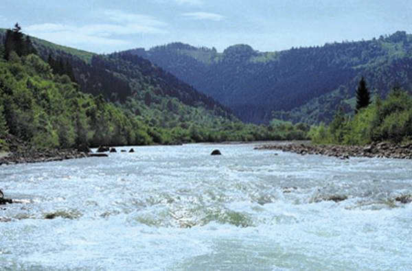
Fig. Cheremosh River near the village. Marinich, Putivlsky Mr.
Vysotna explain natural conditions. Because of significant differences in the heights of the Carpathians there is a vertical change of natural conditions. According to the features of soil-vegetation cover CarpathianThere are five high-altitude slopes of zones: 1) the piedmont zone of mixed coniferous forest-wide and onions (up to a height of 600 m), where sod-podzolic soils grow mixed forests of oak, cypress, fir, alternating with meadows, often under cultivation, 2) the lower mountain forest zone (approximately to 1100 m), consisting of beech and mixed spruce-fir-beech forests;3) upper mountain forest zone (up to 1 500 m) submitted by fir and fir-fir forests. In both mountain forest zone is dominated storm mountain-forest soils; 4) subalpine zone (1500 - 1800 m) where common crooked and woodlands of undersized pine, alder, juniper and cereal-motleygrasslands; 5) Alpine zone (above 1800 m) with low shrubs and grass meadows. Subalpine and alpine meadows cover meadows, where widespread mountain meadow soils. Subalpine meadows are richer in species composition, and more of an high thick. Are noted widespread cereal plants (kunychnyk, tonkonih Alpine, Carpathian chaff, mitlytsya white) and flowering motley grass (delfiniya, Dyahel, buhyla, bather European, valerian trykryla). Large thickets of meadows create bushes: cranberries, blueberries, heather, evergreen rhododendron Carpathian.
In the animal world is dominated by the Ukrainian Carpathians forest species - red deer, roe deer, wild boar, wolf, fox, marten, rabbit, squirrel. Occasionally there are lynx, wild cat. Many birds.
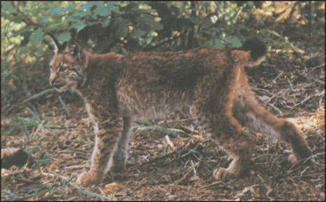
Fig. Lynx
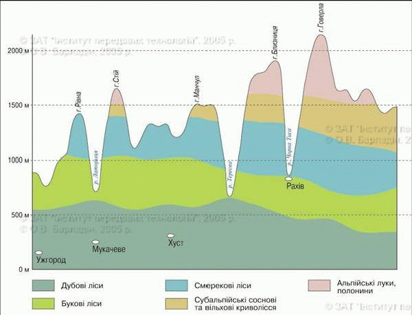
Scheme EL poyasnosti
Amazing Ukraine
Crooked crooked
Anyone who traveled Ukrainian Carpathians, probably familiar difficulty overcoming unusually dense thickets of low trees stelyatsya the slopes of mountains near their peaks. They create pine and alder, which became crooked forms in the harsh mountain climate conditions. The locals call them respectively zherep "and"lelych”.
Remember
Ukrainian Carpathians - is average height, that four parallel strands (External Carpathian Mountains, Carpathians Verkhovyns'ka platoes-and-Montenegro Poloninska Carpathians and Volcanic Carpathians) stretched from northwest to southeast in Western Ukraine.
The highest part of the Ukrainian Carpathians is array MontenegroAnd the highest peak - g Hoverla.
Due to significant variations in heights of the Carpathians explain observed high altitude environmental conditions.
 Questions and tasks.
1. Which part is divided into geographical edge Ukrainian Carpathians?
2. Name the major mountain ridges of the Ukrainian Carpathians.
3. Why Ukrainian Carpathians are like old mountains?
4. Where in the Ukrainian Carpathians there are views similar to high?
5. What is important for network Carpathian rivers?
6. How does the height of the soil and vegetation of the mountains?
 English