§ 35. Precarpathians and Transcarpathia
1. Remember, with all forms of relief borders Carpathianheight.
2. Which tectonic structures responsible Transcarpathian lowland?
Precarpathians. Precarpathians extends stripe width of 30 - 45 km along the Outer Carpathians - between the north-eastern mountains and river performance valleys of the Dniester and Prut rivers. Carpathian height-500 has an altitude of 200 m. At its core is CarpathianwhippingThat was formed between the fold structure and the edge of the Carpathians East European platform. He filled in wrinkled folds of sedimentary rocks. Numerous rivers that flow down from the mountains to rozchlenuvaly Precarpathians series of broad valleys that surround the elongated platoes Hills.
In sedimentary rocks associated spreading depression in Precarpathians oil and natural gas, sulfur, sodium and potassium salts, wax, natural building materials, and mineral water. Most of these minerals are mined for a long time, so they deposit is exhausted.
The climate is temperate continental Precarpathians. He climate similar to other regions of Ukraine, which lie on the same geographical latitude. Average January temperatures of -4 ° C, July 19 ° C. Average rainfall reaches seven hundred mm. Damping over the territory.
Precarpathians cut by a dense network of rivers - upper reaches Dniester, Prut and their tributaries (Stry, candle, Limnytsya, Bistrica). They flowing spring (due to snow melting) and summer (due to rains in the mountains). Often there are floods. River quite stormy, but leaving the mountains to the plain, they spovilnyayut stream and lay in the valleys plenty of solid material brought from the Carpathian Mountains. Therefore, in line many rivers, islands, branched hoses. In the valley of the upper Dniester was a lot wetlands that almost completely drained.
Carpathian Hills covered sod-podzolicand brownsoil-podzolized soils. They once grew platyphyllous forests (Mainly oak and oak-beech with an admixture of hornbeam, maple), and elevated areas - mixed forests (with an admixture of spruce and fir). Now they cover less 25% Precarpathians territory. In the eastern part sometimes preserved prairie vegetation, typical steppe.

Title says
The name of the river Rod interpret differently: Herodotus called it Scythian river Poratha – wavyFrom Sarmatian word name can mean wideFrom Greek - turbulentFrom the Iranian-Scythian - prytka, ambulance. Stry comes from the Scythian and Sarmatian words and means fast, riffle, Stream; Candle - From the Old Slavic - light, Bistrica –Bystre fast.
Transcarpathia. Transcarpathia occupies the extreme southwest part of the Carpathian physical-geographical region. Natural conditions of the area significantly different from the other parts Ukrainian Carpathians. Almost flat Transcarpathian lowland (110 m over RM) is part of the extreme Serednodunayskoyilowlands. At its core is Mizhgirya depression, filled as sedimentary and volcanic rocks. Lowland slightly tilted from the foothills to the valley of the River Tisza. Uniform flat surface in some places broken volcanic lifting - Berehove horbohir'yam (With heights over 360 m). They are the result of breakthrough magmatic rocks on the surface during the active tectonic movements.
Complicated geological structure area resulted in the presence of various minerals: polymetallic, aluminum and mercury ore, gold, brown coal, salt, construction materials. Common sources of mineral waters of different chemical composition.
The climate is temperate continental Transcarpathia, but much warmer lowland areas of Ukraine, which lie on the same geographic latitude. This is because the mountains protect it from cold air masses from the north and east. Average January temperature is -2 ° C, in July - 20 ° C. Rainfall over 750 mm per year.
Transcarpathian lowland crosses river Tisa and many of its right tributary - Borzhava, Latorica, Уж. Slight slope surface and small depth of river valleys make it difficult to surface runoff, so Some places are swamping. During heavy rains and melting snow reduced space in the mountains often flooded with water. Floods and flooding, which Transcarpathia is quite frequent, "real disaster for local residents.
The soil in our region like Carpathian. In the past, wide-plain was covered by forests (oak and beech). Now they almost lost.
Records Ukraine
Small in area Berehove Transcarpathia region can claim first place in Ukraine number of found minerals that have industrial importance for different industries. There are kaolin, tufy volcanic, andesite, trahity, riolite, basalt, alunite, lead-zinc, copper, barite ore, gold, sand.
Nature and Wildlife. Lowland region of Transnistria and in Precarpathians belong to the oldest human-inhabited areas in the country. First natural resources attracted settlers to the land, primarily plant, animal, land, water. Rozselyayuchys territory, people and fired vykorchovuvaly forests on foothill plains, making the land with relatively fertile soils on farmland and meadows - on pastures and hayfields. Riches of the forest and natural mountain facilitate penetration of pasture rights in the Carpathians.
Over time, the agricultural activity added mining, logging. Along foothill cities have. A Carpathian passes were paved roads and railroads, rivers raft. The mountains and foothills attracted healing sources, clean air, swift streams, and picturesque scenery. There were centers of rest and rehabilitation - Yaremcha, Rest in Truskavets Svalyava.
Now Plain is Prikarpatskii vysokoosvoyenymy areas where prevail natural and man-made agricultural landscapes (70%). In the mountains they combined with forestry. Forests and meadows - great natural wealth Carpathian mountains. They are respectively 50 and 35% of the total area of the region. Indigenous inhabitants of the Ukrainian Carpathians are Ukrainian highlanders - Hutsuls, Jaunty, Lemkies. Their economic activities, daily life, traditions, customs extremely closely with the surrounding natural environment. Carpathians them glorified in folk songs, tales, legends.
Natural-territorial complexes different parts of the Carpathians are characterized by originality and uniqueness. But often excessive and irrational use of natural resources last sometimes led to the endangerment of natural landscapes. For their preservation in Carpathians declared protective over 1 500 objects.
Carpathian Biosphere Reserve includes 8 offices, which are created in the Transcarpathian region ranges Montenegro, Svydovets, Maramorosh, Volcanic in mizhhirniy Valley. There are protected natural complexes of different height levels - from low-lying (“Narcissus Valley” near Justo) to high (g Hoverla). Under Protection taken thickets narcissus, which is a relic, a very old forests (Forests) - beech, spruce, beech and oak, fir, oak and others. Nature Reserve “Gorgan” established to protect forests age of fir, spruce, beech, cedar on slopes.
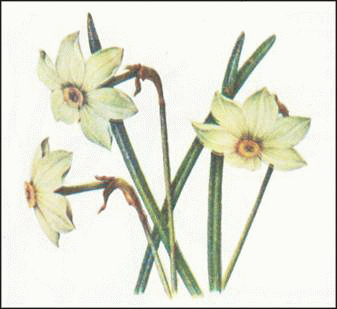
Fig. Narcissus
National parks are designed how to protect nature and provide conditions for civilized leisure people in attractive areas. In particular, the zone of influence Carpathian National Nature Park includes mountain territory Gorgan and Chornogory(Around Yaremcha, Vorohty, Yablunytskyi pass, Goverla) Parks Huzulschyna " і “Vizhnitsky”- Pokutskyi-Bukovina Carpathian Park "Skolivski Beskydy " - Array of the same name Outer Carpathians. Peculiar brand is a lake in the Ukrainian Carpathians - Pearl National Park Synevyr. In mountain lakes, swamps and rivers where the sources Protected beech, beech-fir and spruce forests. Uzhanskyi National Park includes landscapes Polonyny and platoes-Verkhovynsky ranges. He became part of the first in Europe Polish-Slovak-Ukrainian biosphere reserve "Eastern Carpathians, the largest among similar facilities in Central Europe.

Amazing Ukraine
Guests from dolednikovogo period
It can be described as wild Mountain Daffodils. They remained in the valley р. Khustets in our region and elsewhere in Europe more not grow. Amazingly, as a result of glacial geological disasters period, a large piece of soil with plants will slip from the mountains into the valley of the river and there survived. This place is declared reserves - "Valley of Narcissi" is part of Of CBR.
Title says
River names Tisa and settlements Tysiv, Tysovets, Tyslovederived from the name of a tree thousand berry. It is known from the Jurassic period of the Mesozoic Era (over 180 million years ago). Yew grows very slowly and reached a record age 2 - 3 thousand years. For wood properties, that people have used since the Stone Age for bows, axes and homes, it called no decayed wood. Now Tysiv left little, the largest array - in the natural-Prince's Court.
Remember
Carpathian Upland and lowland region of - A geographical region of the Ukrainian Carpathians, which are linked with mountain Carpathians but different from natural conditions.
To maintain the unique and peculiar TPK Ukrainian Carpathians created natural reserves, national natural Parks and other pryrodnozapovidni territory.
 Questions and tasks.
1. Compare Precarpathians relief and Transcarpathia. How is it different?
2. Where formed warmer climate - or Precarpathians in our region
3. What natural disasters happen in Precarpathians and our region
4. What are the natural landscapes dominated by DEPOSITS AND Transcarpathia in past?
6*. Why north-eastern foothills of the Ukrainian Carpathians formed height, and in southwest - plain?
 English