§ 20. Lithospheric plates
1. Remember, called the lithosphere.
2. What are the types of crust?
Formation continents and oceans troughs. Modern conceptions of the Earth crust based on drift hypothesis (Displacement) Continents. Its advanced in 1912 German scientist Alfred Wegener. He suggested that the millions of years ago on earth there was a giant continent Pangaea (Land only). He was surrounded by a single Ocean, which absorbed all the water. Over time supermateryksplit into Lavraziyu і Gondwana. Later they were also divided cracks, breaks, and broken up into separate mainland depth. Away (Drifting), these fragments Pangaea become modern mainland, and between them formed ocean basin.
But A. Wegener failed to explain how the move could continents. Subsequently, scientists have concluded that the lithosphere can not be solid as such as shell eggs. It is comprised of separate blocks - lithospheric plates thickness from 60 to 100 km. They are divided faults, but like a giant mosaic, exposed backing another. Plates are on the viscous, plastic surface Asthenosphere. Sliding in there, they moved very slowly, as if flying at different speeds.
Thus, debris Pangaea - Continents, oceans and depression located on the lithospheric plates and with them are able to move. Most plates include both the mainland and oceanic earth crust.
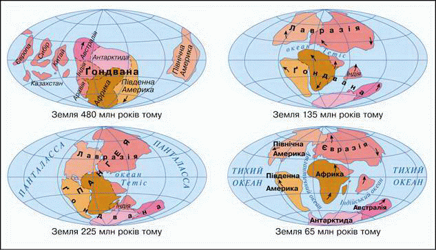
Fig. Lithospheric Slabs of past eras
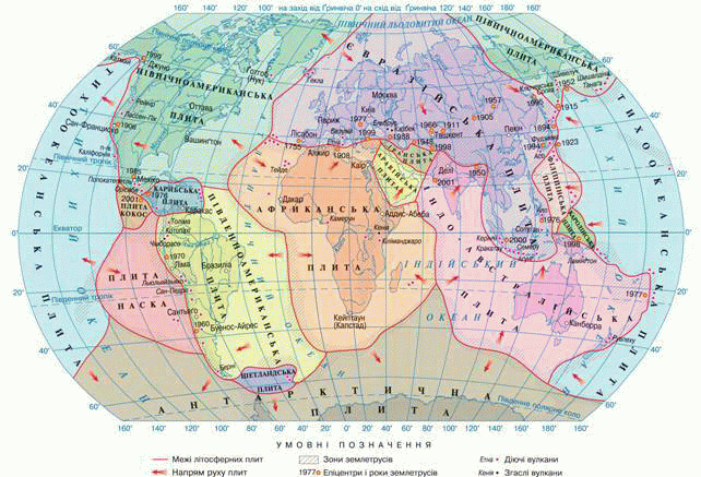
Fig. Modern lithospheric plates
Movement lithospheric plates.The forces that are capable of moving plates of lithosphere, arise within our planet. Therefore they are called internal forces Earth. They arise during radioactive decay and displacement molten materials in the upper mantle. The internal forces are pushing lithospheric plates, and they move along the faults. There are slow and horizontal vertical movements of the crust.
Most there are considerable horizontal movementslithospheric plates. Moving, plates can converge, or rozsuvatysya move relative to each other. When the slabs convergingThen during clash in their countries zmynayutsya folds formed on the surface of the mountain. For example, at the junction of plates Indo-Australian and Eurasia have Himalaya mountains. If facing the mainland and oceanic plates, the ocean that has a higher density, sinking under the mainland. Then on the mainland as well there are mountains and along the coast - deep depressions (troughs). For example, at the junction plates Nazca і South American any Peruvian Andes mountains and Chilean and deep troughs.
If plates slidingThen formed faults. Most faults occur on the ocean floor, where the crust is thinner. Molten mantle substance breaks rises from the depths. It rozshtovhuye edges of plates, poured and solidifies, filling the space between them. It breaks in places on the ocean floor is lengthening of the crust. It created new areas of the earth's crust as valopodibnyh raising giant, called the Mid-ocean ridges. For example, rozsuvanni South American and Africa plates at the bottom of the Atlantic Ocean formed The NorthMid-ocean ridge. Thus, under the ocean crust continuously updated.
Internal forces of the Earth and cause vertical movements:slow raising and lowering some portions of the crust. For example, North part Scandinavia rises to 1 cm per year, and the sea retreats. These are the layers of sand and clay with remains of marine organisms occurring at an altitude of 150 m above sea level. Thus, this area once was his bottom, and then rose to such heights. At the same time coast NetherlandsFor several centuries, falls at 3 mm per year and the North Sea occurs on land. Residents forced to defend the lived-in land, building high (25 m) dykes and dams along the coast. Some areas in the country already located below sea level. In Ukraine, the largest rise recorded in the east Kirovohrad and north Zhytomyr areas - Almost 9 mm / year. At the same time the Black Sea area Odessa falls at speeds of almost 1 cm / year. Vertical movements are taking place very slowly, but constantly and everywhere. They cover vast areas and are accompanied by indented or sea attack. Rising land changes over time and lowering vice versa. Because vertical motions are called oscillating movements the crust. These movements take place very slowly - from 2 to 10 cm per year. They are invisible for humans. Failed to detect them through the comparison of satellite images taken of artificial satellites.
As see robe bears the earth crust as a thin sheet of paper, moving it sometimes break or zmynayuchy folds.
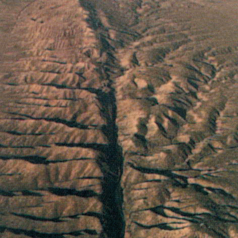
Fig. Faulting San Andreas in California was formed as a result rozsuvannya plates
True and moving areas of the earth's crust. Movement of lithospheric plates indicate that Earth's surface is relatively stable and moving plot. Relatively stable areas called platforms. It lithospere plates underlying the continents and ocean trenches. Moving Zone areas are seams between the relatively stable platform. This area is quite narrow, but span thousands of kilometers. Therefore they are called seismic belt (From the Greek "seysmos" - Fluctuations). They coincide with places faults on land and in oceans (in the Mid-oceanic ridges and deep gutters).
Scientists found that the lithospheric plates move at least horizontally, with strict mathematical laws. Knowing their current position, direction and speed movement can be simulated by computer boards position in any moment: whether past or future. Consider, for example, through millions of years Australia shift north Atlantic and Indian oceans broaden and Quietreduced in size.
Thus, lithosphere is in constant motion. Her movements - a natural phenomena that appear differently in different parts of it.
 Questions and Tasks
1. Name and show on map lithospheric plates of the Earth.
2. Lithospheric plate on which we live? What is she on plates neighborhood? As they move relative to each other?
3. What are the consequences of lithospheric plates junction?
4. What happens in places of distinction lithospheric plates?
5. What proves the vertical movements of the Earth surface?
6. What changes can cause a lowering of the earth's crust?
7. Which way Mapping images of objects on the map "structure of the Earth's crust?
 English