SECTION II. GENERAL DESCRIPTION OF NATURAL RESOURCES CONDITIONS AND UKRAINE
Topic 4. Tectonic structure
§ 11. Tectonic structure
1. Remember, as called relatively stable and moving areas of the earth's crust.
2. What structure have a platform?
3. What are the signs on the platform of distinguished panels and plates?
Major tectonic structures. Tectonic structure - A large area earth's crust, deep limited breaks. Structure and movements of the earth's crust studies geological science tectonics.
As you know, major tectonic structures is a platform and the moving belt. Platform - A relatively stable area of crust with a rather flat surface, is folded in place of destroyed buildings. It has a two-layer structure: overlies bedrock bottom, made of solid old rocks on it - sedimentary cover formed by younger sediments. On the platform emit panels and boards. Shield is upraised until the land surface area of crystalline base platform. sedimentary cover on it is a low-power and not solid. Board - This platform area where foundations sunk to a depth everywhere and blocked in sedimentary basins.
Rolling zone - This elongated area of the earth cortex, within which long held ancient and modern movements continue the crust. In a moving belt distinguish folded facilities, Region (Foothill) flexural deformations.
In Ukraine such as common tectonic structures as Depression - deeply concave areas of the earth's crust filled with sedimentary and volcanic fat. Submarine distributed on platforms and movable zones, as well as areas of their connections.
Limits tectonic structures displayed on tectonic map. It also states folding, during which they were formed.
Platform. The major tectonic structure that underlies the territory of Ukraine is an ancient Eastern European Platform. Its foundation consists of Precambrian crystalline rocks (granite, basalt, gneisses, crystalline schists, labradorite, quartz). On the platform rises Ukrainian Shield. This is one of the oldest the Earth's crust in Europe. Bedrock is slightly offset (Several tens of meters) thickness of sediments, and in many places Precambrian rocks are on the Earth's surface. Solid wide band stretches almost 250 km in 1000 km along the right bank of the Dnieper and goes to the Azov Sea. Ancient faults shield broken into large blocks.
On the western slope of the shield is Volyn-Podolsky plate. It diving crystalline basement under thick sedimentary rocks gradually increases from tens of meters (in the north and east) to 4 km ( southwest). Especially there is a strong deposits of sandstones and limestones. In western part of East-European platform plate moves in Galicia-Volyn cavity. Thickness sedimentary rocks (sand, marl, chalk), there is growing up to 6 km. In the south platform is Black Sea depression, is written in the same sediments - from 1 to 11 km (Black Sea shelf).
Along the northeast border of Ukraine in its limits comes Voronezh crystalline massif. As in the Shield, bedrock was about coming to the surface, but throughout the thickness of sedimentary rocks blocked in half a mile or more. Between Ukrainian shields and the Voronezh massif stretches a long, narrow and deep Dnieper-Donetsk Basin. It is one of the deepest depressions within the whole of the East European platform. Cavity written in sedimentary rocks, whose maximum power reaches 20 km.
In the extreme east of our country Trench enters Donetsk folded building, Which was formed in place deflection of the crust. There's many layers rocks (sandstone, limestone, gypsum, coal, etc.). during hertsynskoyi plicate era were crumpled into folds.
In the ancient East European platform in the boundary Ukraine calling of young platforms. They serve as the foundation destroyed folded structures that were formed during hertsynskoyiplicate era. Western platform wedged narrow "tongue" of western Ukraine, and immersed in the thick rock Carpathiandeflection. Scythian platform covering the lower part of Crimea, adjacent to the her part of the Black Sea and Azov Sea bottom most.

Records Ukraine
By number and diversity of major tectonic structures that face on Ukraine, our country is a leader among European nations.
 Amazing Ukraine
Earthquake platforms
Despite the stability base platform, sometimes in its ancient deep faults occur upheaval. This causes local earthquake measuring up to 5 points at the epicenter. Specifically, in 2002 epicenter of the earthquake was located in the village Mykulyntsi in the region, and in 2007 - In Krivoy Rog.
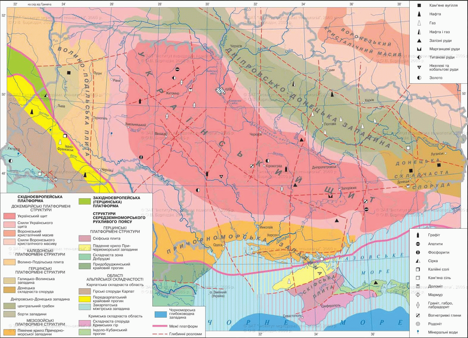
Fig. Tectonic structure
Working with map
1. What platforms are the basis Ukraine?
2. Name the tectonic structures in within the East European platform.
3. Where are folded system?
4. What tectonic structures covered Carpathian fold system?
Mediterranean moving belt.The main tectonic structures are the Carpathian belt fold system, fold-brylova Building Mountain Crimea and Black Sea depression.
Carpathian fold systemThat is at least West is part of a larger structure - the Alpine orogen. The long geological development and manifestation processes horotvirnyh several epochs resulted in a very complex structure system, the spread of powerful strata of different breeds origin and age. Along with the relatively young sediments (sandstones, clays, shales) system composed Precambrian gneiss, granites, quartzite, crystalline schist. Its axial part is Carpathian folded structure. It bahatokilometrova thickness of sedimentary rocks ere in folds, which are often broken and shifted. They onto the north-east to the nearby Carpathian whipping. Deflection filled sedimentary rocks (up to 4,5 km) and a zone Carpatho-docking system of the East European platform. In the South west adjacent to the fold structures Transcarpathian cavityAs part Serednodunayskoyidepression. It is composed thickness of sedimentary and volcanic rocks, which formed in result of penetration of magma along the fault lines.
Folded-brylova Building Mountain Crimea is south of the Crimean Peninsula. Western and southern part immersed in the bottom of the Black Sea. The building formed sedimentary and volcanic rocks. It folds affected numerous discharges, shifts and overlap.
Black Sea depressionThat occupies most deeper Black Sea is a remnant of the ancient arch - Sea Tethys. Crust beneath the ocean mostly type (ie no granite layer).
Area of modern seismic activity. Modern Seismic Zone activity associated with the Mediterranean moving belt. In the Carpathians and Crimean-Black Sea region earthquake possible 6 - 8 points for 12-point international scale. Recent devastating earthquakes in Ukraine were in 1927p. Their epicenter located in the waters Black Sea a small distance from the southern coast of Crimea. In Carpathiansepicentres of the earthquakes in 1977 and 1986 pokiv located in Romania. Then fluctuations crust felt a substantial part of Right Bank Ukraine.
Records Ukraine
З ІV Art. BC to the present day in Crimea were about 80 strong earthquakes.
Amazing Ukraine
Earthquakes in the Crimea
In 1927 occurred in the Crimea two earthquakes that have caused destruction on the coast of Sevastopol to Feodosia. Specifically collapsed part of the rock palace in the famous "Swallow Nest. Since there was no destructive earthquakes. However, sensitive seismic instruments annually capture dozens of weak aftershocks. Most of the epicenter is in the Black Sea between Yalta and Hurfuzom at a depth of 10 40 km under the bottom - where Black Sea depression plate dives under the continental earth crust.
Remember
Major tectonic structures within Ukraine are: ancient (Precambrian) Eastern European movable platform and the Mediterranean zone.
In the East European platform distinguish the Ukrainian shield Volyn-Podolsk plate, Galicia-Volyn, Donetsk-Dnieper and the Black Sea basin, Voronezh crystalline massif.
The main structures in Mediterranean belt is moving Carpathian fold system and fold-brylova Building Mountain Crimea formed Alpine orogeny in the era.
In Ukraine and are long (hertsynska) Donetsk folded building and youth (pislyahertsynski) And Scythian Western platform.
The Mediterranean zone is moving area of modern seismic activity.
Tectonic map - a thematic map, which shows the limits tectonic structures and indicated folding, during which they were formed.

Questions and Tasks
1. What does tectonic map?
2. What structure have a platform? What is called a shield and stove? What boards and panels formed in Ukraine?
3. What structures are distinguished within the East platform?
4. What is called a moving belt? What zone widespread in Ukraine?
5. What are the features fold-brylovoyi facilities of the Mountain Crimea?
6. What folding, most prominently in the geological Ukraine's history?
7. Where in Ukraine are seismically active zones?
 English