§ 38. Azov Sea
1. Remember that water objects of Azov Sea is connected to the Atlantic Ocean.
2. What rivers flow into the Azov Sea?
Geographical location and Coast line. In the southeast of Ukraine goes the distance almost 400 km to the shores of the Azov Sea. Its area as the sea was - 39 thousand km2. On the map it looks great bay of the Black Sea, connected with it a narrow and short The Kerch Strait. Both are inland seas Sea Basin Atlantic. Azov Sea belongs to Ukraine and Russia maritime border between them is not installed.
The Azov Sea coast is poorly cut. Most Bay - Taganrog, it only partially washed Ukraine. Great bays near the Ukrainian banks have Obytichnaand BerdyanskWhich are separated from the sea in small peninsulas and spits. Strong fighter in the dry Utlyutskyy estuary, separated oblique ByryuchyyIsland. Gulf Sivash vidhorodzhuye of Azov long (112 km) sand Spit Arabatsky Arrow and water exchange with him through the narrow Genichesk Strait.In narrow Perekop isthmus, connecting the Crimean peninsula to the mainland, a man enough 1.5 hTo move on to the Black Sivash Sea.
The average depth of the Azov Sea is only 8 m and the highest - 14 c. Due to river sediments and destruction on the sea coast annual piled about 12 million t solids. As a result, these residues are gradual shallowing.

Title says
Azov Sea in different times and in different nations had different names. Meoty and indica, who lived on the coast before our era, called it Tamarunda – Nurse Black Sea; Ancient Greeks - Meotyda(Name of tribe), the Romans - Meotiyskeswamp, Slavs - Surozh or BlueThe Arabs - Bar-el-Asia – Deep blue sea; Tatars - Asia – Finally, the mouth (By location in the sea mouth of the Don).
 Records Ukraine
Azov Sea - naymilkishyySeaway in the world. The area is very small, but not least sea: it more than tripled over the Marmara.
Amazing Ukraine
Asia in Ukraine
Narrow (up to 4 km) Kerch Kerch Strait separating Peninsula, which is geographically situated in Europe, from the Taman Peninsula which is already in Asia. Middle of the strait is the island of Kos Tuzla, which belongs to Ukraine. In the early twentieth Art. island really was oblique, connected to Taman shore. However, in 1925 , the bridge during the storm was promoyinoyu blurred. So in Ukraine is a small piece of the Asian territory long 6,5 km and width 500 м.
Amazing Ukraine
Gnyle more
Sivash Gulf coast is among the most water cut through Ukraine large number of peninsulas and islands in the Gulf of many shallow water, which flooded only periodically during the east wind that nahanyayut water from the sea. Great salinity and its mostly stagnant state causing an unpleasant odor through what was called the Gulf and Gnyle sea.
Climate і water supply. Climate of the Azov Sea is similar to the climate Black Sea lowland. The temperature in summer average at 22 ° C winter - from -5 to 0 ° C. In winter there are storms. In the Kerch Strait year round stelyutsya fog. On the coast in the summer breezes blow.
The Azov Sea is quite different from Black properties of water. In the summer of Azov water due to shallow warm to 32 ° C. In winter the sea freezes near the coast almost 3 months. In the Azov Sea ice drift is often (moving prevailing winds). With strong wind formed hummock - blocks of ice accumulation.
January July
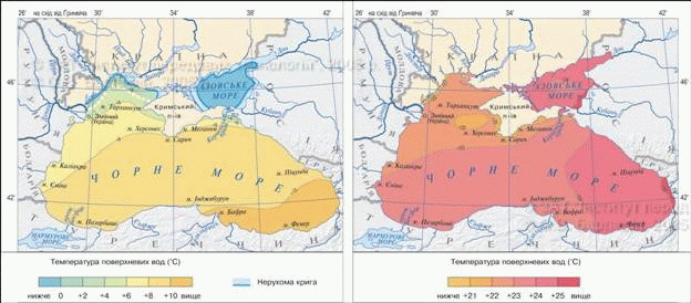
Fig. Temperature
Average salinity in the Azov Sea is low - not more than 13 ‰, and in the coastal zone may be reduced to 2 ‰. Instead, she Sivash Bay 10 - 15 times higher than average in the sea. Water Gulf warmer than the sea, soon evaporated under the hot southern sun and comes to the state of brine and salt into a. In summer the bay glittering surface salt crust, like ice skating. Salt is mined in Syvash long, Chumak rolls transported across Ukraine and even abroad. Now salt and used as chemical raw materials.
January July
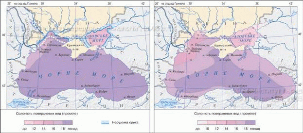
Fig. Salinity
Transparent waters of the Azov Sea is low because that there is plenty of plankton and suspended solid particles. Color of water open sea blue-green and off - the yellow-green.
The movement of water. In the Azov Sea water course determined by the wind. Predominates water movement in the southwestern and north-easterly direction. However, such trends are very brief and volatile.
The largest waves occur near Arabatska Arrows. On the whole basin is constantly observed nahinno-zhinniphenomenon. The inflow of fresh water in the Sea of Azov to the rivers Kalmius Byrd Obytichna, Salgira and other small the bulk water are Don and Kuban. Much of the fresh water enters the basin with precipitation: a year at sea in 1950 added км3 water (20% of its water volume). Some of the water passing into Sivash, much of evaporates from the sea surface, some kind of flow through the Kerch Strait submitted to the Black Sea. In dry years, in contrast, when an inflow of fresh small water and sea milli, Strait inflow increases more salt Black Sea waters. The flow in a sea of insignificant because it has no direct connection to the ocean.
Because of the small depth of water in the Sea of Azov well mixed, they are saturated with oxygen. The bottom is covered with silt and shell, due richness of molluscs. Coquina also covers the coast and braids.
Natural resources and environmental protection. In the Azov Sea grow red and green algae, aquatic flowering plants. Wildlife is still limited. With the spread of fish pike, anchovy, whitebait, sturgeon, beluga, herring, flounder, mullet. In sea to spawn and feeding the fish comes from the Black Sea. Most of the fish - near the coast of the Kerch Peninsula. From there, its hundreds of thousands of tons sent to all ends of our country. For biological productivity (number of tons of seafood, which is per unit area) Sea of Azov is different recently been in first place among all the seas of the world. However, in recent decade mass of plankton in the sea has dropped almost a third, which led to significant reduction in its ryboproduktyvnosti. This was due to increased untreated waste water from industrial and municipal enterprises, intensive use of agricultural fertilizers and pesticides in river basins, pollution from a shipwreck.
On the deterioration of the ecological impact of sea also reduce the freshwater river flow, especially Don and Kuban, and after construction hydroelectric power plants on them (HPS, reservoirs, irrigation canals). As a result, decreased revenues from the land of nutrients needed for algal and plankton, as well as increased salinity. Loss of many species organisms also contributed to the penetration of water in the middle of the Black Sea sea-bottom layers of the Azov Sea, causing the water became ill get mixed, and oxygen does not fall in deep layers. The major danger for organisms of saturated with poisonous substances drainage water from rice fields flowing in Sea of Azov.
Bottom of the Sea of Azov promising for extraction Oil and natural gas. Sivash medicinal mud used for treatment, and from its brine produced soda, bromine and magnesium.
Azov sea coast with the warm climate, sandy beaches - an important recreational area Ukraine, where the base leisure resorts. Small islands, peninsulas and spits saved inviolable nature-territorial complexes, they serve as nesting sites many birds. For their protection created KazantipNature Reserve and Azov-Syvas'kyi National Park.
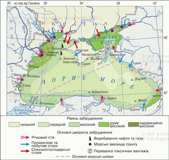
Fig. Pollution
Amazing Ukraine
Medusa-predator
End ХХ Art. spread in the Azov Sea Black Sea jellyfish predator. It consumes plankton and mortality after its poisonous remains accumulated on the bottom. This led to the formation of dead zones in the sea, in which initially disappeared on all fours, and then the fish industry.
Remember
The Azov Sea is one of the smallest area and is naymilkishym sea in the world. It has low salinity, well warmed and oxygenated and nutrient substances for animals throughout water column.
Bay-Lake Sivash has a very high (do220 ‰) and salinity is a major reservoir of sodium, magnesium, bromine salts.
The Azov Sea has a high fish productivity, but due to pollution and changing the chemical composition of water is constantly decreasing.

Questions and Tasks
1. Why the Sea of Azov is similar to the Black Bay Sea?
2. Using a map, determine the length Azov Sea from west to east and from north to south.
3. Give the comparative characteristic temperature regime and salinity of the Azov and Black Seas.
4. What are the similarities and differences of organic World of Black and Azov seas?
5. What caused environmental problems of the Azov Sea? What are ways to overcome them.
6 *. List the physical and geographical features Gulf Sivash. Until you are known reservoirs of the world is similar in some characteristics?
 English