§ 2. Conception Earth in ancient times
Knowledge of the Earth in primeval times. In the old days (40-30 thousand years ago) is primitive people had to learn about the environment to collect fruits, fish, hunt wild animals, escape from natural forces Nature. Primitive hunters and gatherers tried to expand the lived-in places due to more distant lands. So they are increasingly piznavaly space.
Landscapes The people portrayed in the form of notches on the walls of caves, the bark of trees, bones animals. It passed to future generations about hunting grounds and traps on the way to new places. These ancient drawings discovered in many parts of the world -Europe, Asia, Africa. Ancient Ukrainian also left behind a geographic context. Under archaeological excavations in the Cherkassy region of mammoth tusk found records made our ancestors have 13 thousand years ago. If you look closely, you can see it hills, forest, river.
Vysikayuchy symbolic signs of support materials on the environment, man created schematic drawings area. They are believed by ancient maps, true, very primitive. Having long before they shew writing. That distinguish new rivers, lakes, mountains, forests have already known, people complained their names. The names were passed orally from generation to generation. So people produced geographical experience.
Oldest navigation and discovery. Names of the first travel history is not saved us. And she could not: they were all men. Expanding beyond known lands they came across a water obstacle - the maritime area which is surrounded by dry land. Not surprising that people tried to find means to overcome them. Findings Ancient boat shows that the ship was invented over 6000 years ago! The earliest significant voyage of Discovery and made the ancient Egyptians. They lived on the shores of AfricaMediterranean і Red Sea. It is known that for 3 000 years ago the Egyptians swam vdovzh coastRed Seato the south. At the time, even nobody knewAfrica (Then called herLibya) On all sides washed by the sea.
This discovery made the Phoenicians - the people who lived on the eastern Mediterranean coast. The Phoenicians were the brave sailors. In VI Art. BC. e. they are three years obihnuly Africa, proving that it is surrounded from all sides water. On their voyage information told Greek historianHerodotus.
Swimming Phoenicians around Africa is most significant swimming ancient times. Although the names of the first travelers are unknown, but the business they did - overcome distance roz'yednuvaly nations. People gradually began to know each other. Ran the trade routes that went boldest. Of their stories about the unknown land of people who lived there began to consist geographical picture of the Earth.
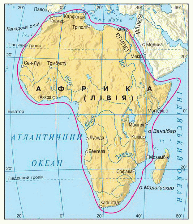
Fig. Swimming Phoenicians around Africa in Article VI. BC. e.
 Interesting
geography
Interesting
geographyAbout swimming Phoenicians
Probably, it was 595 years BC, when near southern tip of Africa appeared strange ship. They were once shiny covering potriskalasya, huge sails burned. Paint that it had covered with horsy head wood on the nose and kept up fish-tails at the stern, was awash. Deadly terror seafarers covered when the coast Somalia nalitav furious wind, when the coastal waters near the equator hang coral reefs in the Mozambique Strait when the ship caught strong current. However, mariners have captured the joy and confidence when they found that the shoreline turned southwest ...
By this time we just do not know when there was no This courageous voyage, nor the number and appearance of the ships, which sailed Ancient mariners, no name at least one of them. However, as could be.
German traveler Paul WernerLange, The twentieth century.
Title says
Interestingly, the names of parts of the world that we use to date, derived from Phoenician words:EuropeofErebus- Event AsiaofCAM- East.
The idea of shape of the Earth. Form our planet's diverse peoples of the world imagined in different ways. Plainsman Earth appeared flat and hill - as the mountains. In ancient India, imagined her flat disc, which was laid on the backs of elephants. In Asia, where towering mountains Himalayas, the world believed axis mount Meru, which is located around seven Oceans. In ancient Japan, attributed the Earth cubic form. The Egyptians saw our planet as ovoid sphere. In ancient Greece one imagined the Earth disk resembling a shield warrior, others - in the form of columns, on one end of which people live. This holistic array of land omyvavsya Ocean Rico.
At the other end of the world people of America - Aztecs - imagined Earth in the form of 5 squares, which are located in a checkerboard pattern. In center - the expanse of earth gods, surrounded by water. Below - the division of the world into four sectors, each with their signs, their colors, their plants and animals. Other people of America - Incas - see Earth as an empty cube.
Thus, the most common was the idea that the Earth flat. It flowed from the knowledge of ancient people of the world. Knowledge then came to relationship with the nearest surroundings. In each spot surface seemed flat. Therefore, the sum of flat surfaces also should be flat. Hence the impression of a flat Earth. Of course, such views were far from modern.
 Question
and objectives
Question
and objectives
1. As initial people piznavaly world?
2. What geographical data transfer simple cartographic sketches of people Ancient of days?
3. Why invented the boat was crucial to know the world?
4. What is significant geographical discoveries made Phoenicians?
5. Why swimming Phoenicians around Africa was so long?
6. How people in ancient times imagined shape of the Earth?
 English