§ 6. Continuation great discoveries of the Earth
The first circumnavigation. When found that H. Columbus discovered the land had nothing to do with India Spain prepared the next expedition. She again led the foreigner - PortugueseFernandMagellan. The ultimate goal of swimming was very practical - get to spice Islands (Molucca), Near the coast South-East Asia. Magellan, like Columbus would reach their new - Western - Way.
Expedition traveled to Europe in 1519. Rounded South America, was to find passage from the Atlantic ocean to another. Magellan cost a lot of effort find the problem. Later the name of his name -Magellanic. Almost four months on ships sailing infinite water on the Earth's largest ocean. He was calm, there were no any storm. Therefore Magellan named itPacific. Instead, swimming without food and water was very debilitating.
The long-awaited land -Philippine Islands -off the coast of Asia does not become seamen happy respite. There, Magellan and many of his comrades killed in battle the natives. Completed Magellan expedition colleagueJuanElkano. He passed the Indian Ocean, rounded the south of Africa and returned to Spain in 1522 losses were great: of 5 caravel remained only one telling name "Victoria" ("Victory"), with 265 people returning home only 18. So almost 3 years (1080 days) were the first circumnavigation. It was a landmark XVAnd art. The expedition, which traveled to the west, returned east. Europeans first crossed the Pacific Ocean. It was found that all the oceans combined with each other forming the oceans. Changed understanding of the distribution of water and land on Earth's surface: it turned out that most of the water takes. Round- travel practically proved that the Earth - the ball, similar to the one zmaystruvav MartinBehaym.
 Interesting
geography
Interesting
geography
Strangers serve Spain
У ХV-Hui Art. Spain took myself to the service of many prominent foreigners. List names is impressive:Christopher Columbus(Italian)Amerigo Vespucci(Italian)Fernand Magellan (Portuguese)SebastianCabot(Englishman, an Italian by birth). Having offered them refuge, Spain advantage of their abilities. Strangers lifted high fame and prestige Spain, making it a great sea power.
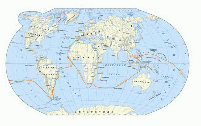
Fig. Route swimmingFernandMagellan(1519 - 1522 years)
Pirates-discoverers. AfterSpain discovery of America became a great sea power. In America Spanish ships sailed to Europe -galleon- With great goods. But the way the Spaniards tried to rob the robbers of the sea - pirates (as the Greeks called them), Sea Dogs (as the Italians call them), filibuster (Known as Dutch). Interceptgalleonjourneyed English, French, Dutch.
Often robbers were looking undercover parking, where you can hide looted. They sailed away from the known area and searched for those that are not marked on the maps. So pirates were examined coast of North America and openlynumerousBay, the mouth of rivers, islands.
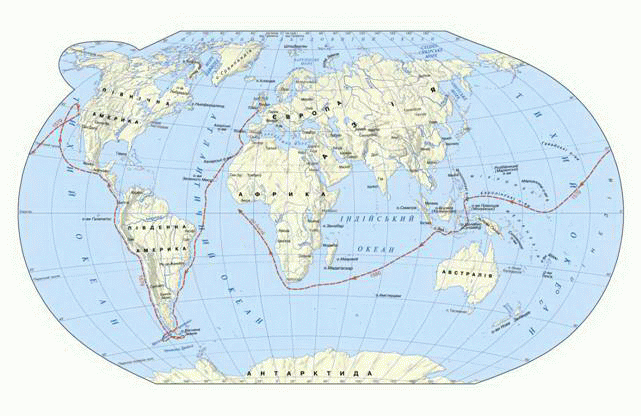
Under black pirate flag and sailed famous English navigatorFrancis Drake. ? Iron pirate, "as it was called, believed himself fearless traveler. He is second after Magellan in 1577-1580 he made a circumnavigation. F.Drakespecified shape the coast of South America, opened Islands in the Pacific. He proved thatFire Land- Not performance? Unknown southern land "and a set of islands for which extends the sea. Later widest strait peace between Earth and Fire Antarctica will be calledStrait Drake. So pirates to swell the ranks of the discoverers of the Earth.
Hiking zemleprohidtsiv.Study of some land in North Asia fell short of the marine discoveries. Even the word "Siberia" Europeans were unknown. In XVAnd art. Russian Tsar Ivan the Terrible ordered: "Russian land measure and drawing the state do." Since zemleprohidtsi campaigns are sent to the north and east "to find a new zemlytsi. Not years, ever passed before the Russians reachedUralsAnd thenSiberia Far Eastand went to the Pacific. Their journeys and discoveries were of finding places, rich fur-bearing animals, and later - with the search minerals.
The first Europeans, in which XVAnd art. came in Asia and began to develop Siberia, wasErmakTymofiyevych. In XVII art. zemleprohidtsiJohnMoskvitin, BasilPoyarkov і Yerofey Khabarovreached the Far East.Vladimir Atlasovfirst was a distant land of Kamchatka and examined its volcanoes.SemenDezhnovumanaged to reach the farthest edge of the Siberian land - eastern cape Asia named after his name. He discovered that Asia and North America separated Strait.
To XVIII. Russians zemleprohidtsi examined and joined to Russia's vast territory of North and Northeast Asia.
Open Australia. To XVII Art. marked on maps of land long known and newly discovered ... imaginary. Imaginary land, located somewhere in the southern hemisphere, involved in LatinTerra Avstralis Incognita- Unknown South Land. That's probable land is called in the second century. ClaudiusPtolemy.
У ХVII art. success finished swimming in her quest organized Dutch. In 1605 ship headedWillem Yanszonomreached the north-western coast of the unknown land. Behind him in 1642 DutchmanAbell Tasmanapproached it from the south and discovered large Islands (nowTasmania і New Zealand). During the second expeditionsTasmancame to this land from the north. Since his voyages, it was found that unknown land - a separate continent. Research the coast of Australia was completed in two years after its opening.
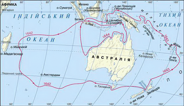
Fig. Route voyagesAbell Tasman (1603–1659)
The days of the new cartography. In the distant swimming Europeans gathered many new geographical information. It is time display them on maps. Cartography has evolved like never before. Enough One look at maps of the time to notice the dramatic changes that occurred in depicts the Earth's surface. Maps began to the increasingly stringent rules. Ever put more lines, inherited fromPtolemy. On the cards is already possible to shape the modern continents. Having first atlases. Their createdGerard Mercator і Abraham Orteliy.
So from naive notions that prevailed in the Middle Ages, people gradually came to knowledge of the Earth through the discovery and mapping studies of the Great Age geographical discoveries. However, geography continues to perform mainly background role.
Interesting
geography
Leonardo geographer даVinci
Genius Italian artist LeonardoдаVinci - the one that Hui century. creatednayuslavlenishuworld picture "Gioconda" ("MonaLisa ") - was also a sculptor, musician, singer, inventor of the amazing machines, architect, biologist, and also ... cartographer and geographer. He studied the flow of rivers, designed channels and the ideal city with the ground and underground streets that potopalo in green. In 1515, he created a map where it shows a probable Southern mainland.
 Question
and objectives
Question
and objectives
1. Using modern physical map of the world, find out which ships crossed oceans Magellan. Where is the strait, named His name?
2. What is the value of the first round the world?
3. Why are pirates called the pioneers?
4. What discovery was made by the Russians-zemleprohidtsyamy? For what purpose sporyadzhalysya their campaigns?
5. Who and when discovered Australia?
6. Locate on the map Sea Island and the Strait, named after one of discoverers of Australia.
7. How has the face of the world "after days of Age of Discovery?
 English