§ 13. Globe
Globe - About’concept of unit model of the Earth. For further study of geography, it is important to remember that the globe-Earth revolves around the rod-axis. In fact, our planet is such a visible, as in globe, the axis has not. Axis can be mathematically calculated and only imagined. Core Globe shows where and which is imaginary tilt axis earth. Those points where Earth's axis in and out of the globe, called poles. Top center - North Pole, Bottom - South pole. It is known that the North Pole Polar star is seen directly above head. Middle of the globe surrounds a dark blue line - equator. The word "equator" in Latin means "rivnodilnyk, Ie one that is shared in equal parts. Equator really divides Earth into two hemispheres: North (On the map - above), where we will live and South (Bottom). At the Earth's surface or poles or equator line is not marked. As terrestrial axis, they exist only imaginary and may affect only a globe and maps. Globus makes it possible to imagine shape our planet, and so he called its volume model.
Features images of the Earth globe. On surface of the globe shows the continents, islands, peninsulas, seas and oceans. That - The surface of our planet, only reduced by several million times. Globes, as plans, are out. It shows how many times in the Globe smaller than the real Earth. In contrast, plans to reduce terrestrial globe surface is very large. For example, on the map of scale 1: 30 000 000 one centimeter uklalysya 30 million inches (Or 300 km) surface. Thus, all objects of this earthly globe in reduced 30 million times.
Globus most precisely to the shape of the Earth. So it only outlines of oceans, continents, islands and other geographical objects correspond to their true form. This means that not on the map distorted the distance between individual points. This is why Earth scientists to discover long used the globe. It is very necessary for educational and scientific purposes.
Distances on the map or define a flexible ruler using strips of paper or thread.
Form and the size of Earth. Is the Earth is round? It appears in modern era of geography and other sciences will be the affirmative not quite correct. Rather, it is not accurate. So Similarly one can say that apple and round, round in reality it never happens.
Modern Researchers believe the planet is not perfectly round. Distance from the center to the poles is 6356 km, and from the center Equator - 6378 km. That pole radius of 22 km less than the equatorial. These calculations indicate that the Earth is flattened near the poles. Its form is not globular, but rather oval. In addition, the surface has significant performances of mountains and ocean basin. Therefore the form of our planet can not be compared which geometric figures. Truth shape of Earth scientists named geoidWhich in Greek means "zemlepodibnyy”.
Now using space satellites, researchers can draw the contours of the Earth to the smallest details. However, and this will be only temporary "portrait" of our planet, because its surface is continuously changing.
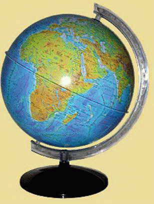
Fig. Globe
 Questions and Tasks
1. What are the features of the image of the earth surface on the globe?
2. What are the imaginary points and lines marked on the map?
3. Determine, using a globe scale, why is the length of the ground equator.
4. Think closer to the center of the Earth at the equator is a person or
man the South Pole.
5. Satellite oblitaye Earth at an altitude of 300 km. Show this scale height in the globe.
 English