INTRODUCTION
§ 1. Object matter and methods
1. Remember, studying geography.
2. What methods of geographical research you know?
Object matter Physical Geography of Ukraine. As you already know from geography courses that have been studied in 6 and Grade 7, Geography very "broad" science. It covers a variety of industries. First of all, geography is divided into physical (natural) and socio-economic (Social). Physical and Geographical Sciences geographical study shell whole and its individual components - the relief, climate, land and water oceans, soils, the vegetation and wildlife. Social and geographical Science explore the territorial organization of society and its individual parts - population, economic, social and political spheres. In his all these sciences branch out "narrower" scientific field, each object has its research.
Natural and social objects and phenomena studied geography within different sizes areas - from the surface of the planet to small areas and individual points. For example, in 7 class you learned the geography of continents and oceans. There are physical geography of Eurasia, Europe, Ukraine or another country. Thus, geography can and divided by a regional basis.
Geography Ukraine exploring the environment and territorial organization of society within our state. It provides general information about the territory of our country, natural conditions and resources, population and economy. The subject of study Physical Geography of Ukraine regularities in the distribution of relief, utility resources, climate, inland waters, soil, vegetation and wildlife, natural areas and other natural-territorial complexes of the country. In addition, Geography of Ukraine is studying the problems of today: the relationship of society and nature, occurrence and worsening environmental problems in our country and others.
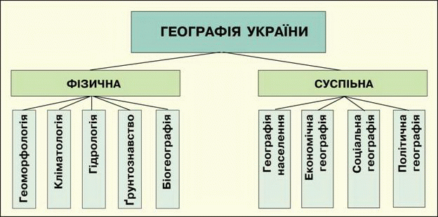
Fig. Division of Geography at the field
Research methods. Geography uses various research methods - methods and ways of understanding the objects and phenomena. Oldest is descriptive method, which now remains one of the main. Describe the geographical object means to find out: what is the object that it structure, where it is located, that its historical development over time, which condition is now that his influence on other objects. Via Geographic comparison (When comparing geographic objects by comparing them and installing them in similar and distinctive characteristics) run natural geographic and economic-geographical zoning, and typology classification of objects and others.
Since ancient times also known expeditionary method research, which has called the field. "Paul", which geographers gather the necessary material is mountains and plains, towns and commercial facilities and others. Field material collected in the expeditions - a "bread" of geography, its foundation, exploring and that science can develop.
Widely used in geography literary technique research. This method enjoying each researcher, as obliged to examine the literature on this topic, use the experience of other researchers and not repeating them, make contribute to the research problem.
Great value in physical geography has palaeogeographical method. His application lets you know about the nature of ancient epochs based on the study rocks, forms of relief, fossil plants, animals and soils. This method enables not only look to the past, but also to predict the future. Thus, predictions about climate change or the latest movements of the earth's crust based on knowledge about the course of these processes in the past.
Traditionally, Geography є Mapping Method research. A good read maps, the researcher can obtain information about objects and phenomenon. Mapping method involves the creation of new maps, using you can draw conclusions about the studied object, to give some recommendations generate forecasts and more.
У XXArt. in geography began to actively use methods such as aerospace, mathematics, modeling. Their implementation was made possible through the use of computer equipment.
Forming area Ukraine. Modern Ukraine as an independent state appeared on the political map of Europe late 1991 Formation of its territory was long and difficult. Oldest governmental entities which arose in the lands of Ukraine were Scythian state (VII – IIIArt. BC. AD) and Bosporus (VAnd BC. BC - IVc.).. The first is Slavic state on our territory has been breeding association Ants (IV–VIcent.) who lived in the lands of Polesie to the Black Sea. Ukrainian historian Hrushevsky considered his preUkrainian state.
In ancient chronicles mention the East Slavic tribes - the clearing, Northerners, Drevlyane, Buzhans, Volhynians, Ukichi, Tyvertsi, White Croats who lived in VII – VIIIArt. large territory. They became the basis of the Ukrainian people. In IX–XArt. lands were united around Kyiv as political and economic core. Prince state Kievan Rus stretched from the Baltic to the Black Sea, from the Eastern Carpathians to the upper course of the Volga. It existed until XIIArt. and then broken up into separate principalities, most of which were defeated by the Tatars in XIII Art. And only two of them - Galician and Volyn, united at the end XII Art. in Galicia-Volyn State managed to preserve its independence and survived to 1340 р.
From the middle XIVArt. and to beginning XXArt. of our country took place in other States: first, Lithuania and Poland, and later - in Russia. З XVIArt. in the steppe formed part of the lower Dnieper Ukrainian Zaporozhye Cossacks, which formed kind of Christian democratic republic - Zaporizhzhya Army. As Hetman state it spread over larger areas in the national liberation War of the Ukrainian people against the Polish gentry in the middle XVIIArt. However, in 1686 Ukraine had been divided along the Dnieper between Russia and Poland. End XVIIIArt. all the Right-Bank Ukraine and Volhynia passed to Russia, Galicia and Bucovina - to Austria.
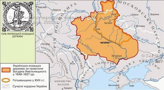
Fig. Ukrainian Cossack state in XVII – XVIII Art.
In XIXArt. area Ukrainian settlement, has nearly one third and reached the shores of the Black and Sea of Azov and the Kuban River. In this area in 1917-1918 biennium have three states - Ukrainian People's Republic (UNRWith capital Kiev), Ukrainian Soviet Socialist Republic (SSR, of capital Kharkiv) And West-UkrainianThe People's Republic (ZUNR, Centered at Lviv). Early 1919 UPR and WUFR announced the unification (union) of their lands, but in tumult of war and hard times of the independent Ukrainian united state was never establish itself.
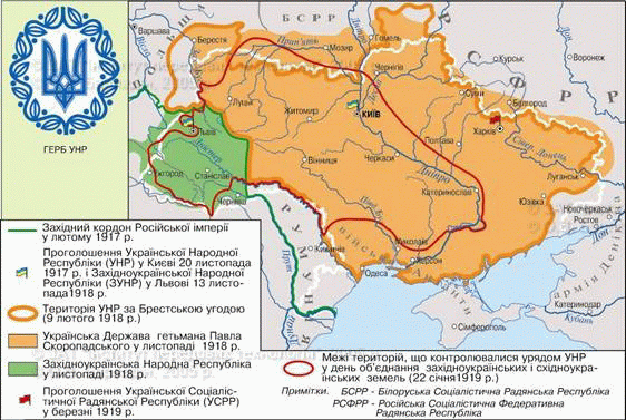
Fig. Restoration Ukrainian statehood in 1917 - 1920 рр.
After the fall of the UPR Ukrainian territory was divided between four countries: the USSR (central and eastern part), Poland (western part), Romania (Bukovina) Czechoslovakia (Transcarpathia). From 1922 to 1991 SSR part of the USSR and had only the formal attributes of statehood. Because of of its borders with the republics of the Soviet Union went to them Ukrainian territory - north Chernihiv, East Slobozhanshchina and Kubanschyna - To Russia, Beresteyschina and Pinschyna- To Belarus. In 1934 SSR capital was moved to Kyiv.
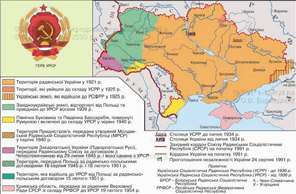
Fig. Formation territory of Ukraine in the Soviet Union
(1921 - 1991's)
State territory of Ukraine finally emerged after the Second World War. In 1939 of the USSR entered western land border with Poland was finally established in 1945 (Part of this land ended outside Ukraine). In 1940 were annexed by the USSR Northern Bukovinaand part BessarabiaAnd in 1945 - Transcarpathia. In 1954 to Ukraine from the Russian were transferred Crimea. Then state territory of Ukraine did not change. August 24, 1991 Supreme Council of USSR declared independence Ukraine. Since our country is sovereign and independent.
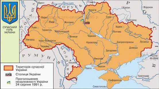
Fig. The territory of modern Ukraine
 Amazing
Ukraine
Amazing
Ukraine
Scythia
Scythia included the current Ukrainian lands - Odessa, Zaporozhye, Dnepropetrovsk, Poltava region of Chernihiv, Podolia, Kiev and Kursk and Voronezh regions of Russia and Moldova. Two and a half thousand years ago Scythia visited Herodotus. Most impressed by his size the country. After careful clarifications he wrote: "Scythia- A square, each side of which is twenty days the way ... "It's really was a huge country, which for millennia had no equal in ancient world.
Administrative System. The territory of Ukraine within its present border is indivisible and inviolable. For public authorities throughout the country and consideration of interests of a portion of the population by administrative-territorial divisionThat is allocated different in size and subordination of territorial units that have their own local power and control. Administrative-territorial units is the highest level Offline Republic of Crimea24 area, and Kyiv city and Sevastopol, that have special status. Units have lower levels of districts, cities, districts cities, towns, village councils, villages (Annex 1).
Records Ukraine
The largest area is Odessa Ukraine (33,3 thousand km2), The smallest - Chernivtsi (8,1 thousand km2).
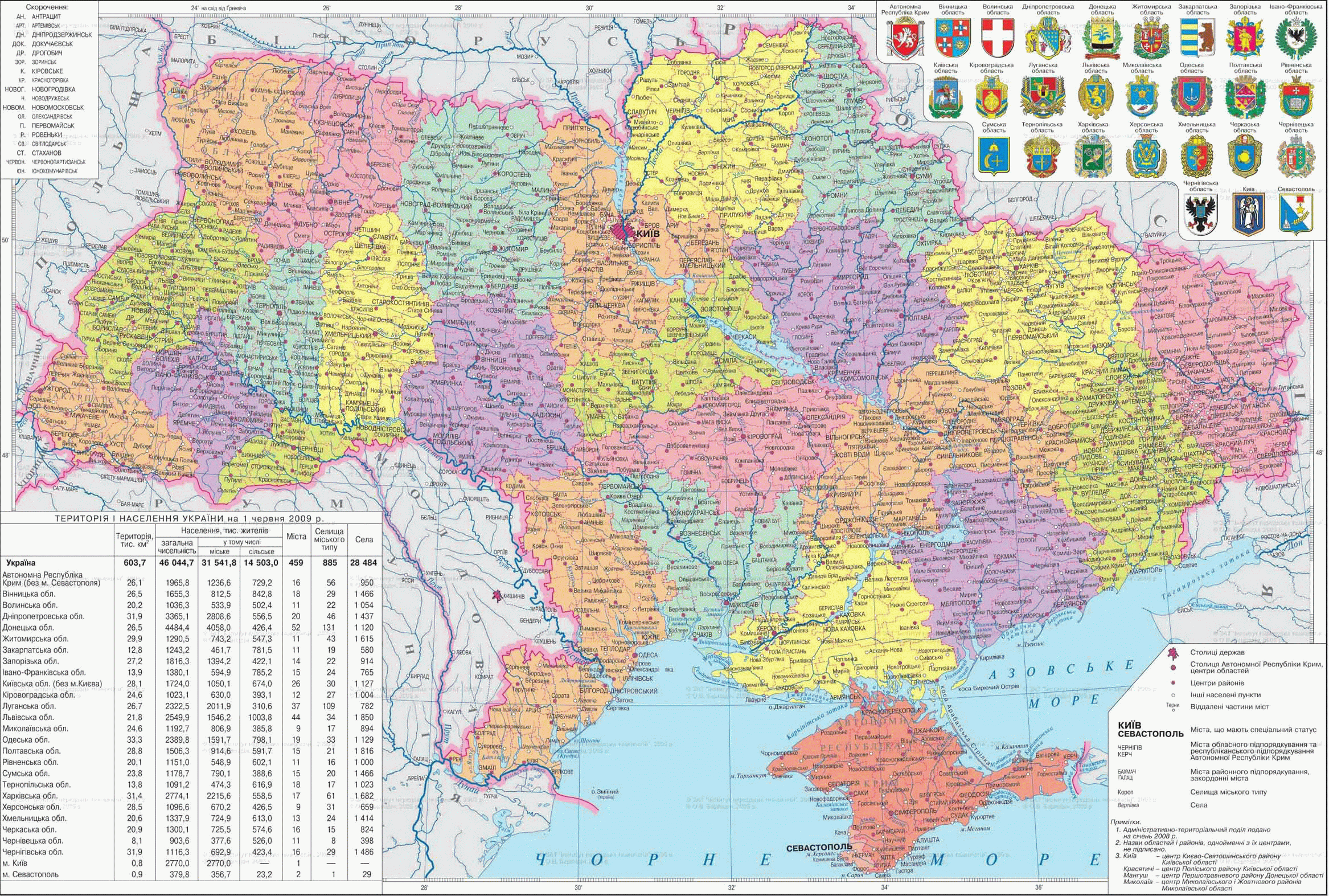
Fig. Subdivisions
Working with map
1. Name the region of Ukraine, located in the west.
2. What areas can be considered central?
3. What areas have the seaside location?
4. Which area is the border?
5. Name the region of Ukraine, having the largest number neighboring regions.
6. What areas are named not for the names of their regional centers?
Remember
The subject of study of physical geography Ukraine regularities in the distribution of relief, minerals, climate, inland waters, soil, vegetation and wildlife, natural areas and other natural-territorial complexes in our country.
Basic methods of geographical research - A descriptive, comparative, expeditionary, literary, paleogeographic, mapping, Aerospace, Mathematics, modeling.
Administrative-territorial system Ukraine provided the division of its territory in the Autonomous Republic of Crimea, 24 regions, Kyiv and Sevastopol (which have special status); units of lower levels are the districts, towns, districts in cities, towns, village councils, village.
 Questions and Tasks
1. Studying physical geography of Ukraine?
2. What are you known methods of geographical research. Describe a method.
3. Tell us about the formation in Ukraine until the twentieth century.
4. In periods of history that existed Ukraine as an independent state?
5. How has the national territory of Ukraine after World War II?
6 *. What is the problem of establishing Modern border Ukraine?
 English