SECTION I. Ukraine and its geographical research
SUBJECT 1. Geographical location of Ukraine
§ 2. Geographical position
1. Remember how determine the geographic location of the object.
2. Which countries are our neighbors?
Dimensions territory. Area Ukraine is 603, 7 thousand km2. За European "Measure" it belongs to the great powers in the world-to medium-sized. By size of its territory - Ukraine largest country in Europe (Takes about 6% of its area), without taking into account Russia which is a Eurasian country, and 44 and - in the world. Maximum length of the country from west to east (1316 km) much larger than the north (893 km). Ukraine was a simple configuration, but the form it is close to correct some geometric shapes.
State territory – a certain part of the earth's surface that is country, limited by national borders. State territory includes: dry land; inland waters, territorial sea, land and mineral wealth shelf under the sea waters, belonging to Ukraine, the airspace over land and waters; conditional territory.
Dry land Mainland can be and island. Ukraine - continental country. It is only very few small islands by area - Byryuchyy, Dzharylgach, Tendrivskaspit and others which are near the coast, and even connected with it sand spits. Only Serpents Island remote from the coast to 37 km.
Вinner water – a river, lake, reservoirs, canals within the land. These include some sea water, namely ports, coves, bays and estuaries, coasts are wholly owned Ukraine (eg water Dnieper estuary, Odessa Bay).
Territorial waters called strip waters in the seas, bays, straits width of 12 nautical miles (about 22.2 km) from shore line of the mainland and islands. Ukraine has territorial water Black Sea, widest part Karkinit Bay. In the territorial waters is the so-called open sea, which is neutral for shipping. But in internal and territorial waters of Ukraine shipping and any other activities (fishing, mining resources) it is governed by the laws of our country. Kerch Straitdivided into territorial waters of Russia and Ukraine line equidistant from shores. Azov Sea not yet divided between Ukraine and Russia on that negotiations between them.
Conventional areas is the Embassy of Ukraine in other states, as well as naval ships and aircraft under Ukrainian flag outside Ukraine.
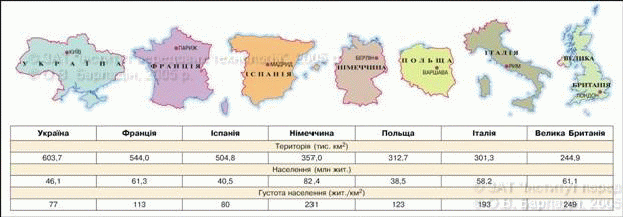
Fig. Ukraine and the major European powers
< --> 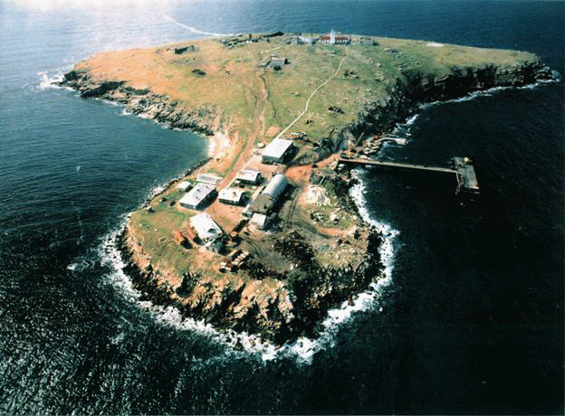
Fig. Serpents Island in the Black Sea
Extreme points and centers of the territory. The end points in Ukraine are: west - Village of Solomon (Near the city of Uzhgorod District Chop Transcarpathian region), in the east - Red Star Village (Milovs'kyi District of Lugansk region), in the north - tract "Petrivs'ke» (Near village Hremiacha Novgorod-Seversky district, Chernihiv region), in the south - cape Sarich (Crimea).
Except extreme, geographers have identified the location of points that represent the center country. Thus, the geometric center of Ukraine (the intersection point average for her parallels and meridian) is located on the outskirts village Dobrovelichkivka Kirovohrad region. In western states near Village Business (Rakhiv district, Transcarpathian region) is geographical center of Europe. There still XIXArt. established symbolic sign. Political same center, the capital of its – Kyiv city. He is approximately the same distance from the western and eastern outskirts of the state, however shifted far to the north of its central points.
 Amazing Ukraine
How many centers Ukraine?
Depending methods of calculation, the centers might be several. Recently geographical center of Ukraine and consider a point on the outskirts of the village Marianivka Shpola near the city of Cherkasy region.
< --> 
Amazing Ukraine
Center of Europe
Symbolic Business sign near the settlement preserved the text in Latin: "Permanent, exact, eternal place. Very accurate, with a special device, made in Austria-Hungary, with scale of meridians and parallels, set the center of Europe. 1887.
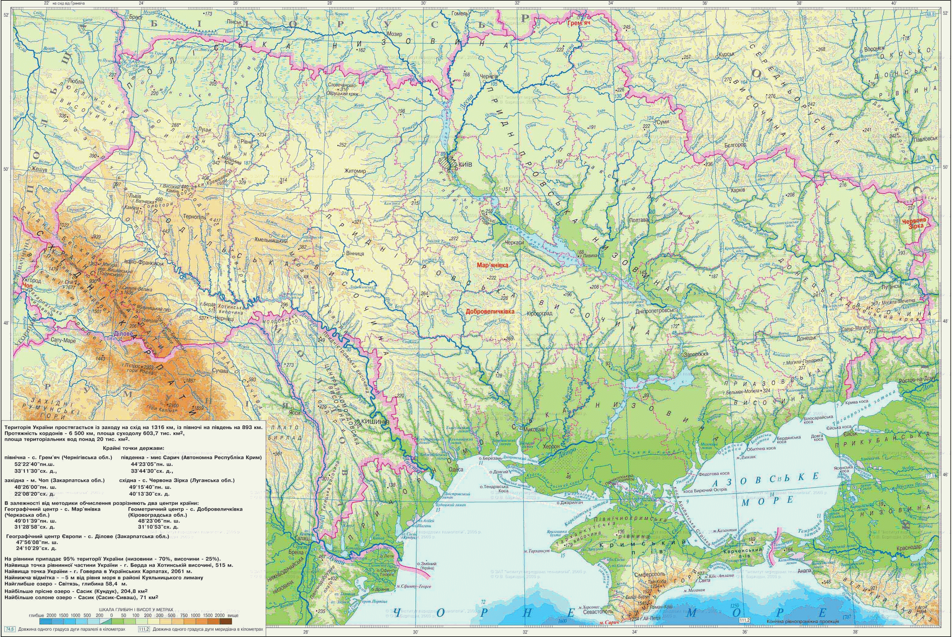
Fig. Extreme points and centers of Ukraine
Geographical position. You already know that the geographical provisions of the territory - the location on its equator, Greenwich meridian, different geographic objects have influenced him. Physical Feature-geographical situation of the country is location of large natural-territorial complexes - and continents oceans, climate zones, natural areas, most forms of relief, and others.
Ukraine located in central-eastern Europe. Its territory lies in the temperate latitudes of the Northern Hemisphere roughly between 44 ° and 52 ° Mon. Rd., east of Greenwich meridian - between 22 ° and 40 ° east. d. The large size and large territory length in the latitudinal and meridional directions cause a variety of natural conditions and rich resources.
Ukraine located at the junction of two major tectonic structures - the old platform and young orogen that represent major forms of relief: plain and mountains. Mountains in Ukraine are an insignificant part of the territory and is the medium and easily accessible. The country is located within the temperate climatic zone in the natural mixed zones and wide-forest-steppe and steppe, where formed favorable climate and fertile soils common. All this creates a comfortable environment for living people facilitates the economic (especially agricultural) mastering territory.
Extremely importance for Ukraine has a wide output in the south to Black and Azov Seas. Through Bosporus and Dardanelles and Marble і Mediterranean Sea Ukraine has a sea connections with all countries continents. The coastline within Ukraine is quite divided. There are many convenient bays, inlets, estuaries. Little islands, including none at large. However, far the sea can Crimean peninsula, Which stretches west TarhankutAnd east Kerch peninsulas. Far south of the Crimea comes in latitude, which was formed climate, similar to subtropical. It promotes the development of resort and spa economy.
State boundaries. State border separates the territory of one state from other areas States or the open sea. On the land boundary line mostly fixed special characters (ie it is demarcation), at sea and it is conditional is the outer limit of territorial waters.
Ukraine has borders with seven countries: the east and north-east - Russia, in the north - BelarusTo the west - Poland, Slovakia and Hungary, In the southwest - Romania (Two piece) and Moldova. Up to 500 miles seas in the south separates our country from the other three Black Sea states - Bulgaria, Turkey, Georgia. The area on the borders is essentially a flat piece and only 440 km - mountain (part borders with Romania, Slovakia and Poland). Almost a third of state borders Ukraine takes place on rivers and canals. Longest border river is Western Bug, Dniester, Dnieper, Tisa, Danube.
Total length of Ukraine's borders have not yet definitively established, because their demarcation carried out only with Western neighbors. But the countries - former Soviet republics (Belarus, Moldova and Russia) border has not agreed. Currently, the total length of land borders of Ukraine is over 5.6 km.
Records Ukraine
Longest State Ukraine has borders with Russia - almost 2 000 km.
Amazing Ukraine
How to conduct maritime borders?
Ukraine seeks to equip its maritime borders. To do this, negotiations with Romania to resolve the border in the area of the Danube. Serpents and Russia on delimitation of Kerch Strait and Sea of Azov. Length maritime border areas of Ukraine in the Black Sea is now 1053 km, in the Azov sea - can be 250 km or (If the sea is recognized as internal to Ukraine and Russia, and along the border will equidistance from the coast line), or about 400 km (if be recognized as open sea and along the border will be territorial waters).
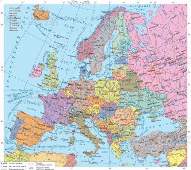
Fig. Ukraine on the map Europe
Working with map
1. Name the country that is Western neighboring Ukraine.
2. Which country has the longest Ukraine border?
3. Determine which countries and Ukraine borders on land and at sea, and with whom - only on land.
4. Which countries Ukraine has a connection across the Black Sea?
Remember
Area Ukraine is 603.7 thousand km2.
The end points Ukraine are: the West - a village of Solomon (Transcarpathian region) in the east - Red Star Village (Luhansk region), in the north - the tract "Petrivs'ke"(Chernihiv oblast), in the south - Cape Sarich (Crimea).
Geographic Center Ukraine is situated on the outskirts of the village Marianivka(Cherkasy region), and geometric - on the outskirts of the village Dobrovelichkivka (Turkey).
 Questions and Tasks
1. What is the size of the Ukraine? Compare its size with the size of the territory of Europe.
2. Name and show the extreme points on the map of Ukraine.
3. Tell us what you know about the geographic center and where they are located.
4. Describe physical and geographical position of Ukraine.
5*. In Europe, which has a surface area about 10 millionkm2, Are 45 countries. Calculate the average area of conventional European state and compare it with an area of Ukraine.
Practical work
1. On the outline map apply state border of Ukraine.
2. Check the extreme points, geographical and geometric centers of Ukraine and sign their names.
3. Using an atlas, determine the coordinates of the endpoints.
 English