TOPIC 2. GEOGRAPHICAL SOURCES INFORMATION
§ 4. Accumulation and storage of geographic Information
1. Remember, from what is found in geographical information.
2. Give examples of expeditions that were carried by travelers in the distant land.
3. How to distinguish between maps in scale, content and coverage area?
For development physical geography requires a huge amount of data on natural objects, phenomena and processes. Only skillfully Upon learning through various methods information scientist geographer can come to a conclusion summarizing the composition, development, and changing patterns of distribution of the object investigated. For example, only to set the average temperature at some point, you must use at least 240th digital data, that have information about the temperature, measured every 3h every day. A monthly average temperature in January or July, submitted on climatic maps - the result of data processing long-term observations.
Cruise research. The main mode collection of information, facts about the territory were still expedition. Expeditions in the form of long and dangerous journeys and travel, made call the heart of several researchers have long known (recall Travel the ancient Greek scholar Herodotus to countries Mediterranean and Black Sea in ancient times or Italian Marco Poloin China in XIII c.).. You already know that a day of great geographical discoveries many expeditions were directed at searches and explore new lands. They organized a grandiose measures large number of participants. Expeditions have a variety of tasks - military-political, commercial, scientific, educational (swimming Christopher Columbus Fernand Magellan, James Louse et al.). And when there were Academy of Sciences and Geographical Society expedition was purely scientific, such as journey of our fellow countryman Nicholas Miklukho-Maklayin Oceania and Australia. Cruise investigations were long and manifold: studied natural conditions and resources of the territories of their populations, features of economic use. The results of the expeditions have been reports diaries of participants, descriptions of observations, sketches, tables, maps, collections Minerals, herbaria, etc.. Often they were ten volumes and boxes, and their processing lasted for years. Over time, the expedition became more specialized: separately studied soils or rivers, relief or climate, unfavorable natural processes and others.
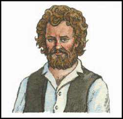
Fig. Nikolai Miklukho-Maklai
Modern geographic forwarding research, conducted in Ukraine, is a field study made during a pedestrian or road trips. Geographer study topography, soils, rivers, lakes, swamps, flora and fauna of Ukraine, as a whole natural complexes (landscapes). working on the ground, they use the information about it obtained in the aerospace observations.

Amazing Ukraine
Geography constantly changes
Geographers should study carefully objects because they are constantly changing. Even changing their geographical names - Toponymy. For towns, they also are "changing". Thus, city Odesa for its more than 2500-year history changed name at least 8 times, and Luhansk only a life expectancy Rights - 5 times.
Records Ukraine
Over 20 years of long walking journey Balkans and the Middle East, made in XVIIIArt. kievlyanin Basil Grigorovich-Barsky!
Stationary Geographical Research. Landline survey - A research Work carried out in specially equipped facilities - Geographic hospitals. They made long long surveillance and change certain natural processes and phenomena in different territories. There are mountain and plain, Polesskiye steppe and hospitals that specialize in the study of meteorological phenomena, water runoff, soil denudation and destruction, relief processes, snow avalanches and others. From XIXArt. conducted in Ukraine as complete (landscape science), fixed research that began in Velykoanadol's'ka hospital in the steppe Azov. Now geographical field research (forwarding and stationary) made Institute of NAS of Ukraine, Universities and other institutions in the country.
Field geographers research expeditions and are not limited to hospitals. In some cases to collect the desired material are carried out scientific Excursions - a sort of mini-expeditions. Most often organize them in the lore searches, gathering of local material. To gather the necessary geographical information can be made and when tourist trips. This researcher combines recreational activities with their academic enrichment.
Collected during the research information is "raw" material, which requires scientific processing and comprehension. It is stored mainly in the funds and archives scientific institutions and can be used by scientists concerned with this or that scientific problems.
Sources geographic information. The sources of geographic information, which while need can benefit all those interested in geography, is a geographical Encyclopedia (eg, "Geographic Encyclopedia of Ukraine in 3 volumes, "Encyclopedia of Ukrainian), Reference, Dictionaries ("Toponymic dictionary ") and others. A large number of processed geographic information contained in textbooks and manuals of geography and scientific papers issued a book or on the pages of periodicals – newspapers, magazines, magazines.
Challenging and variety of geographic information can be obtained from natural, geological, historical, ethnographic, regional museum. Their exposure containing materials resulting from the painstaking research of many scientists different generations.
Various geographic news we receive daily from the media - radio and television. Very often the message is about natural intelligence phenomena occurring in our country and abroad. Broad access to diverse geographic information came from development of computer telecommunication system online.
 Amazing Ukraine
New technologies - Geography
A widespread among pupils gained ProgramGoogl Earth, Reflecting the virtual globe. Thanks to her Internet is available from aerial photography our world, including Ukraine.
Geographic maps and atlases. Important vehicle of information and sources of knowledge about different There is a maps. Geographic map - it generalized thumbnail image of the earth's surface plane, made in a certain scale, using symbols. Maps are model of reality .. They show the location, properties and relationships various natural and social objects and phenomena. Maps made by field survey of the results, according to other sources of mapping, aero- and remote sensing, statistics and literature data. Any geographical research begins with a review of already existing maps for the territory and end the creation of new for her maps. As you know, maps are of various kinds.
Appointment geographical maps is diverse, and as various areas of human activity. They are used for example in research, different sectors of economic activities, military affairs, used as teaching aids in schools as guides for tourist trips. By with maps now solve many practical problems: predict the weather, lay routes of ships and aircraft design and construction of development of agricultural land, carry out environmental protection measures and make the exploration of mineral dug more.
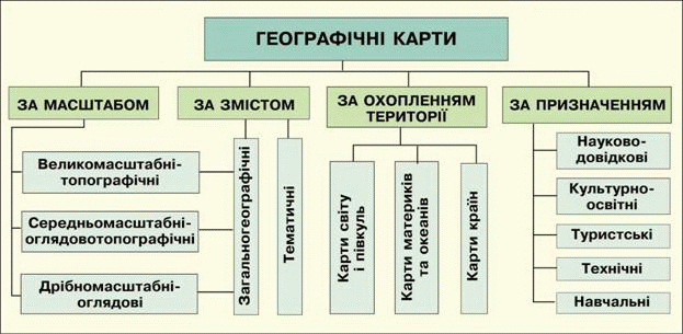
Fig. Classification of geographical maps
Often maps together in geographical atlases. Atlas - A systematic, complete collection of maps created by a particular program. These are, in particular, scientific inquiry atlases (eg, "Atlas of the natural environment and natural resources of Ukraine) educational atlases in geography or history of Ukraine, educational and local history atlases some areas, tourist atlases and others.
Now maps and atlases are not only on paper and in electronic media and information (CDs). These atlases, maps except their own, often filled with large of additional information - text, charts, tables, graphs, charts, photographs, and audio and videos (melodies of hymns and folk songs individual regions, video of interesting places, etc.). For an electronic atlas of Ukraine, which containing dozens of maps of different content.
Modern computer technologies, which allow combining electronic maps, charts, aerospace image the Earth's surface with various information in the tables, called Geoinformation system (GIS). It gives to use, analyze, store, edit, display geographic data. GIS is widely used in the study of problems pollution.
Remember
The main methods of collecting geographic information and factual material is stationary studies expedition tours.
The sources of geographic serve geographic information encyclopedias, dictionaries, reference books, museum exposure, newspapers and magazines, radio and television, Internet, maps atlases.
Geographic map - is reduced, the generalized conditional Vechersky image of the earth's surface plane, made in a particular scale and projection.

Questions and Tasks
1. Name the main ways to collect geographic information.
2. What sources of geographic information you had to use it?
3. In fig. 5 describe the classification of geographical maps.
4. What types of maps in scale, scope and content area contains your school atlas for grade 8?
 English