Topic 5. Relief. Geomorphologic structure
General plan of structure of the surface define the territory of Ukraine plains and mountains. Ukraine has a generally flat surface character: 70 % Of occupied lowlands and 25 % - Upland. Only 5 % area of the country occupied by mountains that rise in the far south and west. The flat part of the country in general slashes from north to south and from west and east of the Dnieper. This is reflected in the direction of flow of rivers and their major tributaries. The absolute height of territory ranging from -5 m (water level Kuialnyk Lehmann) To 2 061 м (г. Hoverla). Such relief is due long history of geological development of the territory, the influence of internal and external forces of the Earth. Top (East-Ukrainian Carpathians Crimean mountains) And large (some lowlands, hills, ridges and arrays) landforms were formed, mainly because of internal processes therefore have a relationship with the main tectonic structures.
Large surface relief forms is complicated smaller forms, created mostly by external processes - the work of ancient glaciers and glacial melt water, temporary and permanent watercourses ground water, wind, human activity. These landforms are in particular Hills, ridges, ridges, mountains, outliers, spurs of ridges, river valleys, ravines, gullies, karst caves, landslides, quarries and piles in mining areas.
General plan of structure of the surface of Ukraine reach the basic forms of relief, their true altitude displayed on the physical map.
§ 13. Plains
1. Remember, as distinguished by high plains.
2. What is the surface of the plains?
Most of the territory of Ukraine is to Southwest large East-, based which lies an ancient Eastern European platform. The average height of the plain part of Ukraine is 175 m above sea level. The highest its points are located on the west - G. Byrd (515 m) and г. Kamula (471 м).
 Records Ukraine
Byrd Mountain is the highest point of the whole East Plain, covering an area of over 4 million km2 and stretches from Precarpathians and the Baltic Sea to the Ural Mountains and from the Black Sea and Caspian Sea to the Arctic Ocean.
Highlands. Highlands wide strip stretching across the Right-Bank Ukraine. To the west the hilly dissected ridge with heights to 370 m - Bore. It is based on Galicia-Volyn tectonic depression. She and Volyn-Podolskywavy plate is the basis Volyn Upland with average heights 230 c. Maximum Height reaches 342 m Mizotskomuridges.
Dnieper Upland stretched between the river valleys Southern Bug and Dnieper. In tectonic against it meets Ukrainian board. The height of a small height (320 m) flat or sometimes pohorbovanu surface. The height divided quite deep, sometimes canyon valleys rivers. Common ravines and beams. The height dropped steeply to the valley of the Dnieper.
Podolsky height formed within Volyn-Podolsk plates (West) and Ukrainian shield (eastern). It clearly appears in relief Hills-Hirnestrand, which form Kremenets logs, Monastery і Holohory. These peaks rise to 470 m above sea level. Intersecting Rise Tovtry (Medobory) - Linearly elongated ridges with flat peaks and sloping hills with rocky cliffs in places. Tovtry folded limestone formed along shoreline of the ancient seas that existed here in past geological periods. Podolsky GRADE overall height is to the south, where it breaks quite high ledge to the Dniester valley and the southeast. For the typical surface deep (sometimes up to 250 м) canyonValley rivers - tributaries of the Dniester left-bank. On the face of widespread ravines, gullies, karst caves.
Southeast of Ukraine is Donetsk heightAssociated with long Donetsk fold structure. East, higher forms of Upland Donets Ridge. Its undulating terrain, complicated locks, combs, outliers, one of whom - г. Tomb Mechetnia (367 m) - the highest mark Upland. The height of the densely divided by deep river valleys, ravines, beams. There's widespread anthropogenic landforms - piles, quarries, embankments, that is connected with a long mining.
Azov Upland devoted to the southeast Ukrainian shyta speech. On its undulating surface are deep ravines, valleys rivers and some increase - inselbergs-graves and taking on the Earth's surface crystalline rocks, and man-made grave-mounds, built by man in ancient times. Highest mark hill - г. Belmak-Grave (324 м).
By the plain part of Ukraine are also Carpathian heightWhich in tectonic relation with Psrsdkarpatskomudeflection - the structure of the Carpathian fold system. The height of the narrow stretches strip between the Dniester valley and the north-eastern slopes of the Ukrainian Carpathians gradually rising from 200 to 850 m. It surface divided by river valleys that flow down from the Carpathians, in particular elongated Upland.
Amazing Ukraine
Steep escarpment Prydniprovska hill on the right riverbank in some areas dissected by deep valleys and beams, resulting in having beautiful horbohirniarea. These are, in particular, Kanev mountains with glorious monastic mountain on which The grave of Taras Shevchenko.
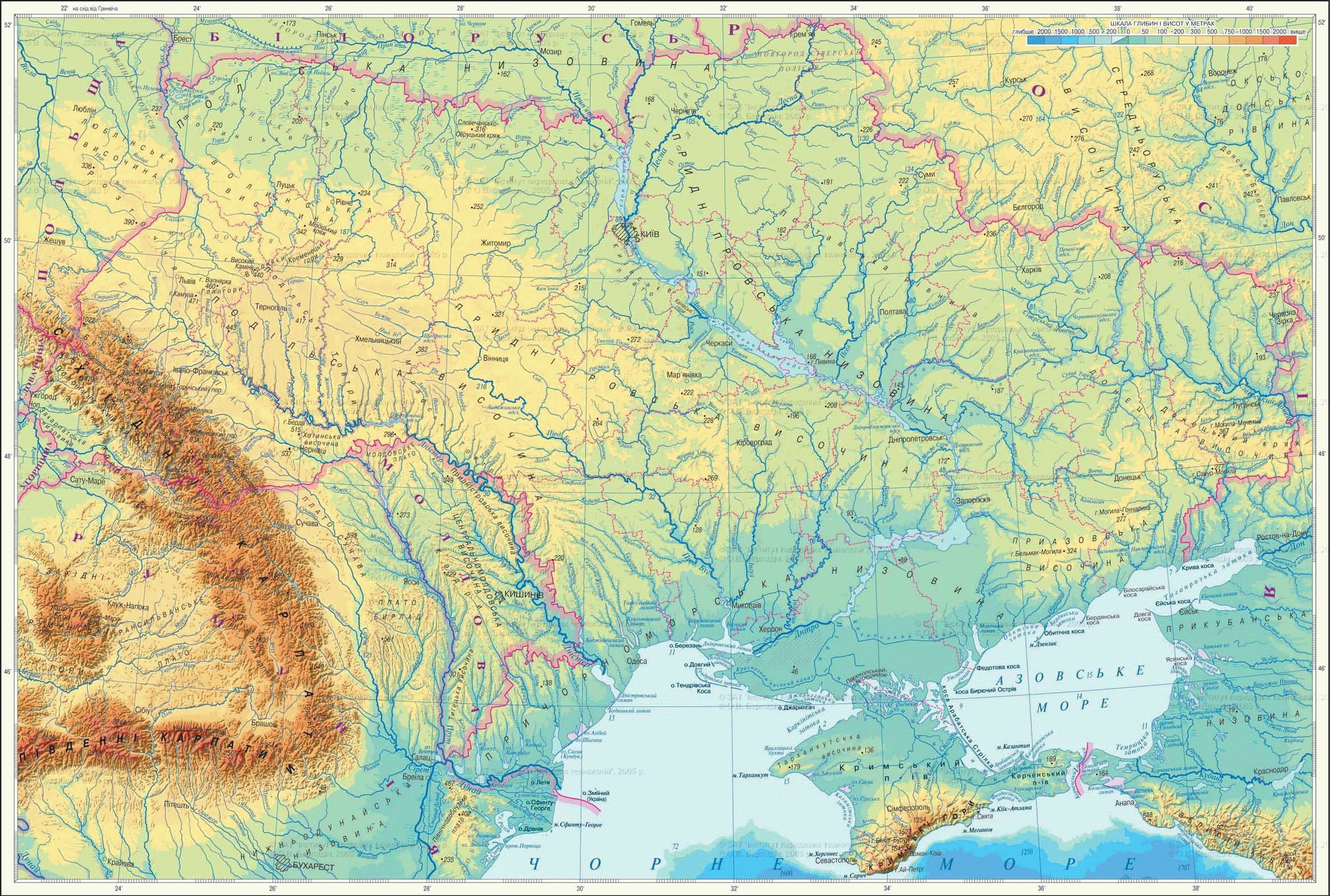
Fig. Physical surface
Working with map
1. What was high, which stretch within Ukraine.
2. Where are the great lowland?
3. For maximum card set absolute height of the main forms of relief Ukraine.
4. Compare physical and tectonic card and the links between tectonic and plains of Ukraine.
Lowlands. Ukraine occupies the northern part Woodland lowland. Its western part lies within Volyn-Podolskplate, average - Ukrainian Shield, and east (on the left bank) - Dnieper-Donets basin. Its average altitude is 150 - 200 c. Maximum mark 316 m has Slovechansko-Ovruchskyi ridge. Lowland densely pomerezhena shallow river valleys. Many forms of relief (low mounds and walls) there sediments associated with glaciers.
Stretches of the Left Dnieper lowlandThat meets the Dnieper-Donets basin. Lowland's height to 170 m. On the surface formed broad river valleys. There are beams and a small increase - the hills and salt domes. Higher part lowlands - Poltava plain - moves to the northeast in SerednoruskuRiseThat comes in from Ukraine some spurs.
In southern Ukraine, located Black Sea lowland. In tectonic against it meets Black Sea depression, and her part North Crimean plain - Scythian plate. Surface Lowland has little GRADE from west to east and from north to south. In the Black and Azov Seas lowland high ledge ends 1940 c. Relief mostly undulating lowlands in the central part - is flat. Violate the plainness of the surface river valleys, gullies and ravines. There are also steppe Pody and saucer - reductions gentle rounded shape.
To the plains of Ukraine is also Transcarpathian lowlandThat in relation with the tectonic Zakarpattya Basin - Carpathian fold structure of the system. Lowland lies in the extreme western Ukraine, and is part SerednodunayskoyiPlain. Its surface is flat, melted, slightly tilted to the southwest by downstream of the river Tisza. Altitude is 110 m. In low-lying areas rises to 366 м Berehovo horbohir'ya – massif ploskoverhyh hills formed volcanic activity. Specific elements of lowland terrain, there are numerous dams were constructed along the river for flood management and flood.
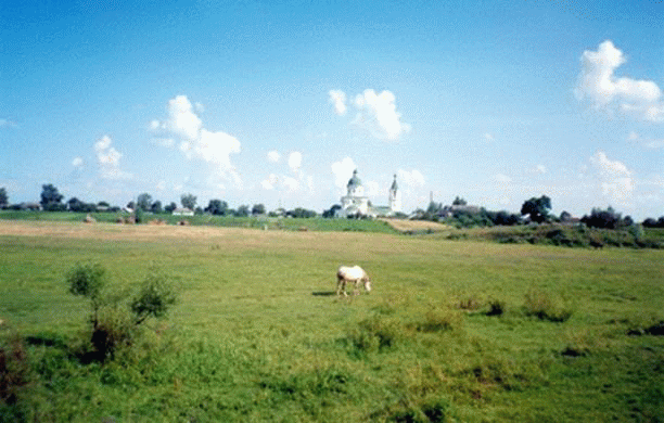
Fig. Dnieper Lowland (Chernihiv oblast)
Remember
General plan of structure of the surface of Ukraine caused by tectonic structures, it determine most forms of relief - the East and the Ukrainian Carpathians Crimean mountains.
The vast majority in Ukraine has flat surface: 70% of it are lowlands, 25% - Upland, only 5% of the country busy corner.
Within Of the East are: height - Dnieper, Podolsky, Volyn, Priazovskaya, Donetsk, Lowland - Woodland, Dnieper, Black Sea, Transcarpathian
 Questions and Tasks
1. Why in Ukraine dominated flat terrain?
2. Name the major landforms of Ukraine.
3. What less complicated forms large surface relief forms?
4. Where are the absolute lowest altitude mark in Ukraine?
5. How tectonic structures and meet the Dnieper Donetsk high, Dnieper and the Black Sea lowlands?
6 *. Find out within a large-scale relief is your area. Describe its surface.
 English