§ 26. Geographical location and study
1. Remember that you already know about the discovery of America.
2. What washed Oceans South America?
Area - 18,3 million км2
Population - 378.5 million people
Average height - 580 m
The highest point on RM - G. Aconcagua (6960 m)
GEOGRAPHICAL PROVISIONS. A looming South America like a triangle that stretches from the north, zvuzhuyuchys, south of hot tropical Caribbean to the snowy and stormy island of Tierra del Earth. Continent crossed the equator in the northern part of the general, so its considerable territory falls much rain. Relative to the zero meridian it lies entirely in the Western Hemisphere. East mainland washed Atlantic, west - Pacific, North - Inland waters warm and deep Caribbean Sea. South America is distant from other continents. And only with North America, it connects to the north a narrow strip of land - Panamanian isthmus. In the narrowest of the isthmus in 1914 was They made Panamanian channel length of 81 km. South America and North America - two continents, which form one of the world - America.
The end points mainland to the north is cape HallinasIn the south - capeFrouerdTo the west - cape Parinyas, in the east - capeKabu Branco. Cape Horn an extreme point of the island South America. The coastline is flat and mostly low cut - mainland almost no large bays, peninsulas and islands. An exception is only south-west coast, where lies archipelago Tierra del Fuego, Separated from South America Magellanic Strait, and from Antarctica - Strait Drake. In 1520, during while sailing the Strait, which would later be named after him, Ferdinand Magellan saw on the bank of lights. Great navigator named this land Thierry del Fuego - Land of Fire. Were it lights fires Tuzemtsy or anything else, will forever remain a mystery. So name appeared on maps Tierra del Fuego.
The largest bay is La Plata (Hui in centuries. Italian Sebastian Cabot chose to vehicles parked in a beautiful bay on its banks it Tuzemtsy exchanged clothes in many silver ornaments, so named bay La Plata – silver). Near the south-eastern coast of the mainland are Falkland Islands (Malvinas) Islands.
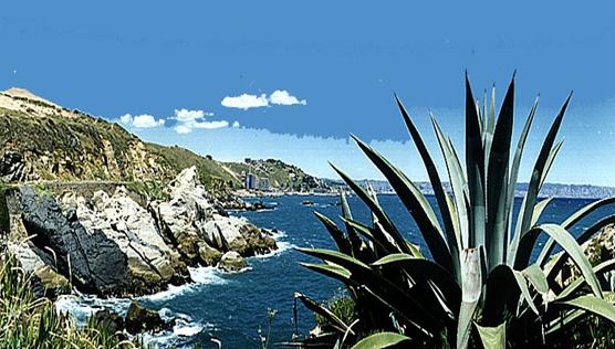
Fig. Pacific coast of South America (Chile)
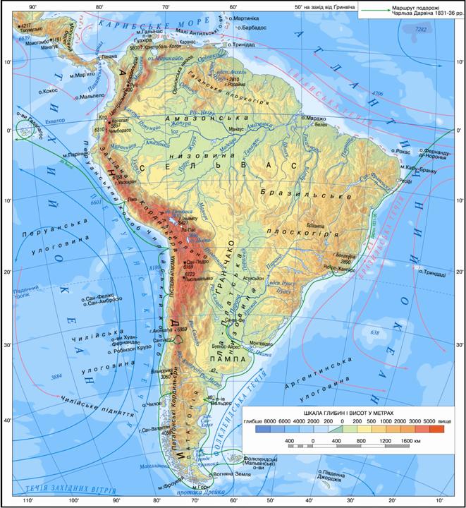
Fig. Physical map of South America
Working with map
1. Find and fix errors in the description of geographical provisions of the continent: South America located west of Africa, south - from Antarctica to the north - from North America. Its western coast washed by the Atlantic Ocean and east - the Pacific Ocean.
2. Define coordinates of extreme points of the mainland.
3. Define length of the continent from north to south (10 = 111.3 km) from west to east at its widest part.
4. Name the warm and cold currents passing along the coast of South America.
5. What features of climate South America will be determined by its geography?
 Interesting geography
Literary Islands
Near the western coast of South America located Alexander Selkirk Island and Robinson Crusoe-. Alexander Selkirk - this is the sailor whose adventures on a desert island Daniel Defoe described the writer in his famous novel "Robinson Crusoe".
Discovery of America. As you know, the discovery of America is concerned with swimming Christopher Columbus in search of sea route to India. In 1492 three caravels, the Santa Maria "," Nino "and" Pint "launched forth from the coast of Spain and took a course to the west. During the month, sailors crossed the Atlantic Ocean and finally first saw ground. She were Big Antilles і Bahamas. J. Columbus sure to hit Asia and called them West Indian (West Indies). After first expedition were three more, and until his last days he was convinced that reached the western route to India. During the first and second voyage Columbus only visited the islands of the Caribbean, and only during the third, in 1498, landed on the opposite coast of South America island of Trinidad.
In the early sixteenth century. sail to the shores of America participated in Italian Amerigo Vespucci. He described public land that appeared abruptly Europe other than their nature, peoples and cultures, and concluded that Columbus was not reached India, and the great unknown of a new land - the New World. On maps, this became known as the dry Land Amerigo - America. Designate new continents America in honor of Amerigo Vespucci proposed German scholar Martin Valdzemyuller. In published in his 1507 book "Introduction to cosmography. New World and new countries, opened with Amerigo Vespucci Florence and four of his voyage, he wrote: "? I do not see why, who and for which would deny the right to call this part of the world Amerigo or America. Originally designated as South America and later the name extended to North. Instead, Columbus's name in the title uvikovichyly only one country South America and then only in the nineteenth century.
Interesting geography
"My goal - as much to see and open ... "
It was written in Columbus 1492 Now that our world is already anxious study of other planets, we have difficult to realize all the great weight of historical events made by those who gave world new worlds, after five centuries ago went to the ocean other continents and other peoples and other civilizations. For Europe, this discovery was needed to look beyond its borders to look for imaginary countries that Columbian made their trip a reality. Later, the discovery of America was considered greatest historical event since the creation of the world.
Jose Augusto Seabara, Portuguese writer
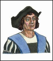
Christopher Columbus (1451-1506)
HISTORY STUDY. Opening America became great geographical discovery. But it was tarnished colonization that followed him. Followed by Columbus in search of new lands and wealth of European conquistadors moved (translated from the Spanish word means conquerors).
. Their trips were accompanied by extermination and enslavement peoples of South America, and desolate land robbery. During colonization of the continent was to explore new geographic and land - were discovered and mapped the coast, the implementation of the first conversion on dry land.
At the turn of XVIII-XIX. made an expedition to South America, German scientist Alexander Humboldt. The objective trips was to study the nature and population of the mainland. He described nature, created the first geological map mainland, collected herbarium of 12 thousand plants. But the main merit was to that A. Humboldt attempted to explain the phenomenon, understand the differences between them ties. About At 20, he work out his material trips. The result of his research a 30-volume work entitled The Journey of New World tropical regions committed 1799-1804 biennium. The scientific value of this work was so significant that Humboldt was called 'second Columbus, and his research -' second discovery of America.
Russian botanist Nikolai Vavilov in 1932-1933 under During his expeditions established the origin of some plants, which was the birthplace of South America.
Interesting geography
Opening conquistadors
In Hui century. conquistadors made several discoveries in South America. Yes Spaniard Francisco Pizarro discovered and explored the Pacific coast of the mainland, the Spaniard Alonso de Ojeda - North coast, including Venezuela - "Little Venice "and a number of islands. A Portuguese Alonso Garcia opened a large river first infiltrator in the hinterland of the continent.
 Questions and Tasks
1. Tell us about the geographical position of South America.
2. Compare coastline Africa, Australia and South America. What are the differences?
3. Why H. newfound land was called the Columbus Americasа?
4. Why Alexander Humboldt called "second Columbus?
5. Consider which of the oceans exercise greater influence on the nature of South America.
1. On the contour map of tick and sign title extreme points of South America.
2. SUBSCRIBE Caribbean Sea, Gulf of La Plata; Strait - Magellan, Drake; Islands - Tierra del Fuego, the Falkland Islands.
 English